Article translated by an automatic translation system. Press here for further information.
Stage of Salamanca to The Cube of the Earth of Wine
Long day separating the cities of Salamanca and Zamora
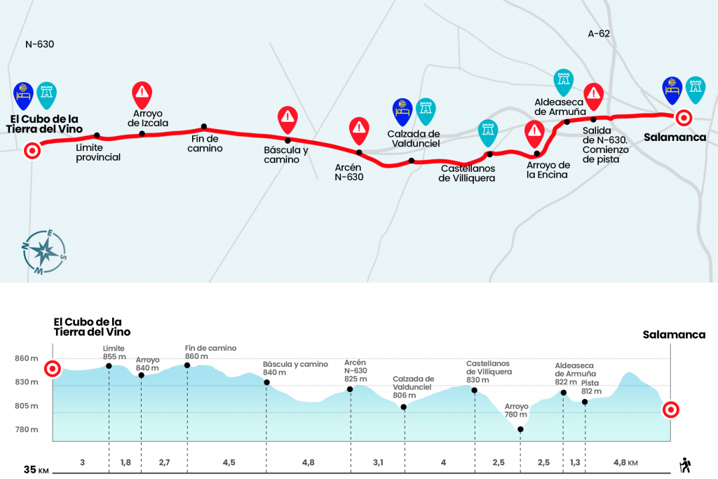
Information about the stage 19: Stage of Salamanca to The Cube of the Earth of Wine
Enlarge map
Points of interest in the stage 19: Stage of Salamanca to The Cube of the Earth of Wine
The route
The municipal hostel of El Cube de la Tierra del Vino is CLOSED until new notice
.
- Km 0. Salamanca(All services)
The first box of this long stage is located on a cobblestone of Plaza Mayor charra. A bronze vieira guides our steps down Zamora Street and the Paseo del Doctor Torres Villarroel, where we will see a cairn that points to the number of remaining kilometers to Santiago: 444. Cheer! We arrived at the glorious Santiago Martín “El Viti”, presided over by the majestic sculpture of a bravo bull, and then we went next to Santa Teresa Jesús College and a shopping center.
Always in the direction of Zamora we leave behind the kilometric points 338 and 337 of the SA-11, which is none other than the N-630, and after a roundabout the football stadium Helmántico rises to our right. We drew below the A-62 and continued through the arches of the N-630. A few meters before the kilometric point 335, we finally leave the asphalt (km 4.8). We made progress to the nearby Aldeaseca de Armuña. We enter Ruta de la Plata Street, then Fronton Street and turn left onto Campillo Street to the parish church.
- Km 6.1. Aldeaseca de Armuña(Bar. Store)
You have to surround this 16th-century temple, turn left and go forward. We see a way to the right. Be careful because it is the old road, now cut off by the highway, that we should not follow. We continue to
rotate, surrounding the town on the paved street, until the next corner,
with an electric post. At this point there are several arrows that encourage us to continue along the right path. This one heads towards some ships, which we pass. A hundred meters away we see the highway and the passage below it. Two hundred meters later there's another crossing. Several arrows tell us to take the runway on the right, that we're still on a slight rise. Then we go down to cross the creek of the Encina (Km 8.6). We then head up the long runway to a football field. We bordered the play grounds and arrived at Castellanos de Villiquera.
- Km 11.1. Castellanos de Villiquera(Bar. Store. Pharmacy)
We cross the village down Calle Vía de la Plata and at the other end, after passing a small park, we continue on a road with taped on both sides. Concentrated on the horizon, in which the tower of the church of St. Helena stands out, we advance without loss to Calzada de Valdunciel. A good alternative for anyone who wants to leave the stage.
- Km 15.1. Valdunciel Road(All services)
On Carrascal Street we reached the Plaza de la Constitución and continued along Calle Ruta de la Plata. At the end of this street we will meet with a row of large cylindrical stones, today as a sculpture and identified as probable remains of miliaries of the XXIV Route of Antonino.
We leave Calzada de Valdunciel crossing over the creek of la Vega, after which comes a trail that passes by a merendero and a small lagoon. Later, according to a metallic signal with the inscription Camino de Santiago, we turn right and continue along a line of more than kilometer and a half that leads us next to the N-630. Shortly, upon arriving at the San Cristobal regate, we passed under the A-66 and next to a booth and landed at the N-630. We go through a river through the N-630 and we go back under the highway to take a thin gravel road. It was created specifically for pilgrims and advances parallel to the highway.No loss, so forget about the N-630. We will cross the SA-CV-115 heading to Valdelosa and follow the front road, always with the reference of A-66 (Km 21.2). Through this road, enabled in 2009 after the opening of the highway, some short section of the N-630 and the old road to access the Cube of the Tierra del Vino, we will reach after almost 14 kilometers to the first Zamorana population of the Vía de la Plata. We enter through Calle Mayor, where we will see the directions to the Torre de Sabre hostel and, at the height of the café bar Hernández, turn left by Calle García de la Serna, continuing along Calle Toro to Eras de Arriba, where is the municipal hostel, which is currently CLOSED.
- Km 35. The Earth of Wine Cube(Hostels. Bar. Store. Pharmacy)
The difficulties
Remarks
In images
What to see, what to do
The hostels

¿Do you want to send any photo of "The Camino de Santiago"?
If you have any photos of "El Camino de Santiago" that you want to share with us, you can send them to us and enlarge the photo gallery
Forum: What pilgrims think about the Camino de Santiago
See all