Article translated by an automatic translation system. Press here for further information.
Stage of the Cube of the Land of Wine to Zamora
The pilgrim crosses the Land of Wine and reaches the city of Duero
Information about the stage 20: Stage of the Cube of the Land of Wine to Zamora
Enlarge map
Points of interest in the stage 20: Stage of the Cube of the Land of Wine to Zamora
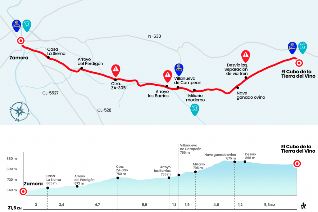
The route
- Km 0. The Earth of Wine Cube(Hostels. Bar. Store. Pharmacy)
From the hostel, undoing what was done the day before, we went down the streets Toro and García de la Serna to Calle Mayor. We turn left, leaving to our right the Conde Retamoso square and, after passing the church of Santo Domingo de Guzmán, we cross the bridge over the San Cristobal creek. Notice, because just fifty meters away you have to get off the road and turn left onto a runway that is born next to a chopera.
They are presented more than five kilometers per piste, always flanked by the route of the train that advances on our right. Thus, with the company of the rails and the oxidized signals of “Eye to Train, Step Without Guard”, we heated motors. Two kilometers from the start of the runway you will receive a panel from the City Hall of Corrales del Vino with the legend Siste Viator, a brief review of the history of these lands that we now tread. Three kilometers later, after the five we announced, yellow signs tell us to turn left at a junction, definitively moving away from the train path (Km 5,8).
In fifty meters we will again divert, this time on the right track. We continue without interruption by this line, which emerged as so many others as a result of the parcels concentration. A kilometer from the last diversion we will see a solitary farm (Km 7) and a kilometer later some masses of pine trees will be present. The path begins to descend gently, exploring a terrain where the vineyards become more evident, and passes along with a modern miliary with the inscription “Vía de la Plata – Villanueva de Campeán” (Km 11,6). The right road leads to the ruins of the Franciscan convent of the Soto. We continue from the front we will reach another similar miliary and after crossing a road we will enter Villanueva de Campeán.
- Km 13.5. Villanueva del Campeán(Hostels. Posada Rural. Bar)
Villanueva runs from south to north through Calzada Street and, after crossing another carreterita, continues again on the runway. A last miliary dismissed our march and in nine hundred meters we passed the stream of the Barrios (Km 14,6). In the next half hour we will not have to worry about the crossings, as we will continue in front. In the background we will see the people of San Marcial (if we want we can deviate to San Marcial which has a bar and then go back to the road route through the ZA-313 in the direction of Entrala), but look, we will not get to it. We have to turn right at a junction. We'll walk in a stream shortly and then turn again, this time to the left. Moving along this new track, with the view of San Marcial on the left hand, we will cross another track and continue in front of a path that ascends a hill. In the echo you can see on the right the village of El Perdigón. We will reach the road ZA-313 or 305, from which we will be able to distinguish the city of Zamora, still far 11 kilometers (km 20,5).
We will advance along the road for a kilometer, leaving it on the left before reaching the Tardobispo crossing. Thus arises a path sunk between the labor grounds that passes along with a farm and several redeemers, where we receive the barrels and balids of its inhabitants. Four hundred meters later you have to turn left and in a few hundred meters to the right. After a line of almost a kilometer cross the Perdigon stream and continue along the right track (Km 25,2).
You can already see the route of the railway and again the signals in a precautionary hurry. The runway leads us to cross a road that leads to the industrial estate located on the left, although we continue in front of this crossing and continue along a blurred stretch that leads to some agricultural vessels.We pass by a few houses, one of which is named La Sierna, and in front we have Zamora almost at our feet (Km 28,6).
We set aside a concrete factory, cross the road and descend the street of Fermoselle, advancing already in parallel to the shore of the Douro River. Some remains of the old bridge are still being kept, flipped and fighting the current. We saved its course through the medieval bridge and entered Zamora, the Roman Ocelo Duri, along the Bridge Street. We continue to St. Lucia Square, where the church of the same name and the provincial museum are located, and we go up the hill of San Cipriano. On this side we will see a large, tan-coloured three-story facade. It is the hostel, which is accessed by the door to the other side.
- Km 31.6. Zamora(All services)
The difficulties
Remarks
In images
What to see, what to do
The hostels

¿Do you want to send any photo of "The Camino de Santiago"?
If you have any photos of "El Camino de Santiago" that you want to share with us, you can send them to us and enlarge the photo gallery

Forum: What pilgrims think about the Camino de Santiago
See all