Article translated by an automatic translation system. Press here for further information.
Sanabrés way
13
367,7
The History of the Sanabrés Way
Between 812 and 814, at the dawn of the Reconquista, in a castro near the episcopal city of Iria Flavia, a hermit named Pelayo saw during the night some burning lights and communicated it to Bishop Teodomiro. He verified the facts and discovered in that spot the mortal remains of the Apostle James the Elder, who had apparently been moved there after his martyrdom, back in the year 44 of our era. This finding was the spark that generated the phenomenon of Jacobean pilgrimages. Now, given that the terrestrial communication routes of those centuries had nothing to do with the current ones and that each pilgrim had no choice but to start the journey on foot from his own home, what are the reasons for the rise of some itineraries and the detriment or non-appearance of many others?
The origin of this Way, let us call it Sanabrés or Mozarabic, as a viable route to the tomb of the Apostle goes hand in hand with the Silver Way, which ascended from the south of Spain, and from a whole series of small pilgrimages or pilgrimages to a dense network of monasteries that emerged on the basis of the Mozarabic repopulation and situated in the province of Zamora, specifically in the beginning of Juan Carlos de la Mata Guerra, in his part corresponding to the book Los Caminos de Santiago in the North of Zamora, expresses this theory as follows: "everything indicates that the consideration of a pilgrim in medieval times was not reduced to the devotee of the Jacobean or the rosemary, but in the broad sense of the term was very open. It was considered a pilgrim to anyone who, to honor the saints, wandered through the roads drawn by local sanctuaries and the cult of the relics of the saints who venerated in them".
Just four kilometers from the Roman road at the height of Granja de Moreruela is the Cistercian monastery of Santa María de Moreruela. It is the oldest in Spain and was known until 1163 as Santiago de Moreruela. In its remains you can still admire the pilgrim's door and fountain. In Tábara, 25 kilometers from Moreruela, before 1137 existed the Mozarab monastery of San Salvador. The same occurs in Santa Marta de Tera, a population that emerged from the abbey of Santa Marta de Riba de Tera. Also in Rionegro del Puente, where at the foot of the shrine of the Virgen de la Carballeda was founded the Brotherhood of the Falifos, which is still in force, owner of the current hostel of pilgrims of the town and dedicated to "the composure of the bad roads, for the comfort of the poor pilgrims who go to Compostela to visit the temple of the Apostle Santiago". The Brotherhood was approved by Clemente VI (1342-1352), and confirmed by Eugenio IV (1431-1447) and Paulo III (1534 and 1549). In San Martín de Castañeda, a town located on the lake of Sanabria, although far from the current itinerary, the monastery of Santa Maria was built in the 10th century. Already in Galicia, together with the Collegiate of Santa María la Real de Xunqueria de Ambía there was a hospital of pilgrims, known thanks to documents of 1520. There is also a record of pilgrim hospitals in Verín, Monterrei, Allariz and Orense. There is no doubt that there was a route drawn between all these religious centers and that, thanks to the countless hospitality samples found by the devotees, this same road that used natural routes of communication became another route towards Santiago.
El Santiago peregrino de Santa Marta de Tera, symbol of the Sanabrés way
The oldest known figure of Santiago with pilgrim clothing, from the 12th century, and located on a front page of the church of Santa Marta, is an overweight carving for its beauty, sobriety and mystery. On its own merits, it has become the symbol of the Camino de Santiago Sanabrés or Mozarabic and still remains its best claim. He wears a zurrón decorated with a shell and a cayenne on the right hand but his main force resides in his left hand, which displays the palm as a greeting. In 1993, on the occasion of the commemoration of the Jubilee Year, coins of five pesetas were coined with the image of this apostle on the obverse.
Documentary references
The Sanabrés Road as an itinerary, no longer Jacobean, but simply of communication between kingdoms and provinces was followed by Alfonso IX in the spring of 1225.He left on May 3 from Santiago, arriving on May 15 to Orense and on May 24 to Puebla de Sanabria. Centuries later, in 1506, Felipe El Hermoso met with Fernando El Catlico in Remesal, after traveling from Santiago and down to Orense and Puebla de Sanabria. Although something fenced in time, considering that the tomb of the apostle was discovered in the 9th century, the first important document concerning a pilgrim who used the Sanabrés way or Mozarabic dates back to 1612. In that year Bernardo de Aldrete, humanist and linguist, began the pilgrimage in Cordoba and, after arriving in Zamora, went to Puebla de Sanabria through the counties of Alba and Aliste. In one of his texts, translated into Spanish today, he says:
"When we arrived at the place of Requejo, first from Galicia, having not snowed before it began to snoop, we rushed to Lubián, going up to the port of Padornelo and went with great haste and work for the ventisca and snow that covered the road. We were helped by the guide and also by the reels and loggers that were passing the port, and with this storm we passed it and arrived to the Padornelo, which is a good place, and we climbed the other port of the Canda of the same fate, with great snow and no less wind"
This manuscript is found in the Archive of the Cathedral of Granada. There are also documentary references to the journey of the Sevillian canon Diego Alejando de Gálvez in the mid-18th century. It went from Santiago to Pontevedra, then to Orense and went down to Castile by Guamil, Laza, Alberguería, Soutoverde, Pereiro and A Canda.
Canadas Reales and Postas itineraries
The Honored Council of the Pastors Mesta, commonly called La Mesta, was created in 1273 by Alfonso X the Sage. One of its tasks was to try to resolve the conflicts between farmers and livestock farmers and to that end, specific itineraries were set up which were called guns. They led livestock between summer and winter pastures and, in addition to being safe, prevented the animals from wiping out growing areas. The longest and most important roads were called Cañadas Reales and their width was 75 meters. These trunk roads were joined by a multitude of chords of 37 meters wide and paths of 21 meters. Like the Cañada Real de la Vizana, which took advantage of much of the Silver Way, the Tera cordel used an existing path that followed, among others, the pilgrims heading to Santiago. The cordel went from Benavente to Rionegro del Puente, Mombuey, Venta de Cernadilla, Venta de la Escoba, Asturianos, Palacios de Sanabria, Remesal, reaching the mountains beyond Puebla de Sanabria. There was also a road known as the Brea, which from Puebla went to Orense by Allariz.
The routes of posts were the routes used by the post for news transmission and were an excellent means of travel. They create the Houses of Postas, something like the mansios on the Roman roads that, located at a regular distance, served to rest from the emissaries. By the maps of that time it is known that by 1789 there was already a direct route between La Puebla de Sanabria, A Gudiña, Orense and Santiago.
Camino de Castilla o Vereda de los gallegos
By this name is known the way used by the Galician reapers at the beginning of the summer to go to work in Castile and that also served them back to return to their homes at the end of the summer. There is no doubt that many others went along the same path, including pilgrims. They went down to the Castilian fields through Alberguería, Cercedelo, Campobecerros, A Gudiña, O Cañizo, A Canda, Lubián, Padornelo and Puebla de Sanabria. On the return they offered their hoces at the Shrine of the Tuiza, just before facing the climb to the portilla of A Canda and entering Galicia.
The itinerary:
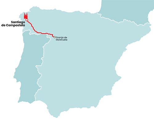
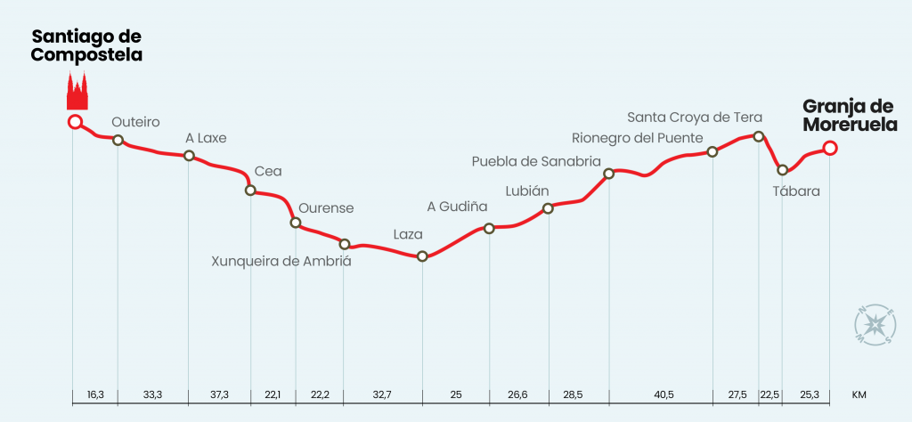
The Sanabrés Way can in itself be an alternative to other Ways of Santiago. Between Granja de Moreruela and Santiago de Compostela there are 367 kilometers by Laza, the shortest alternative after A Gudiña and the one currently following the Guide of Consumer Eroski. In reality, the Sanabrés Way or Mozarabic is a continuation of the Silver Way. Upon reaching the Zamorana town of Granja de Moreruela, the pilgrims who come from Seville or Mérida following the itinerary of the ancient Roman way have two alternatives to continue to Santiago. The first is to continue along the Silver Way to Astorga and link to the French Way towards Santiago. The second option, followed by almost all of the walkers, is to leave the Silver Way and move through the Sanabrés Road to the province of Ourense, through the localities of Tábara, Santa Marta de Tera, Rionegro del Puente and Puebla de Sanabria. Once in Galicia, the provinces of Ourense, Pontevedra and A Coruña continue. At first sight this alternative seems to be the shortest option, but it is not. From Sevilla to Santiago, through the Silver Way and the Sanabrés Road, there are 980 kilometers. By contrast, the Silver Way and the French Way are 963 kilometers.
Signalling:
It's good and there's hardly any black dots. In Zamora it is marked with yellow arrows, work carried out by the Friends of the Camino de Santiago of this province, and with different tablets and stones placed primarily by the municipalities. In Galicia, besides arrows, there is the classic Jacobean cairn with distance indicator. The journey through the province of Orense is also decorated by the original sculptures of Nicanor Carballo, which are of great help to the pilgrim.
Hostels:
More than twenty hostels in 367 kilometers. An average of one hostel leaves every 16 kilometers. The people of Galicia are better but are located at a greater distance. For example, between A Gudiña and Laza you have to travel more than 34 kilometers between the hostel and the hostel and in many other Galician stages the average figure of 16 kilometers is exceeded.
Bibliography:
Rionegro del Puente en el Camino de Santiago, written and edited by Eusebio Rodríguez Carrión in June 1994.
The communication routes in the Iberian Northwest, Benavente, at the crossroads of Caminos, written by several authors and published in 2004 by the Centro de Estudios
Benaventanos Ledo del Pozo.
Chroniclers and travelers north of Zamora, by José Ignacio Martín Benito and edited in 2004 by the Centro de Estudios Benaventanes Ledo
del Pozo.
The Camino de Santiago in the north of Zamora, written by several authors and edited in 2006 by the Centro de Estudios Benaventanes Ledo
del Pozo.