Article translated by an automatic translation system. Press here for further information.
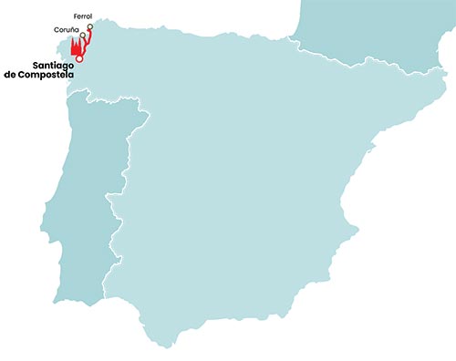
English way
7
155,2
The journey through the fearsome ocean
"You don't think about laughing when you embark for Santiago. For many it is pain. Since you board at Sandwich, Winchelsea, Bristol, or wherever you can, your heart starts shaking. Take the canoe, a sailor, fast for our pilgrims to have a bit of fun, as some will have moaning before it's midnight." This is how this disturbing fragment of the poem Pilgrims Sea-Voyage and Sera-Sicknes prays. If the land pilgrimage was a survival challenge, the sea, at times, still more tested the aptitudes and faith of the pilgrim. In the early centuries of the pilgrimage to Santiago, aboard medieval merchant ships of the Kogge and Hulk type, overcrowded as one more commodity and after having paid the expensive round trip, the pilgrims from beyond the seas headed to the Country of Santiago.
The sea odyssey to the shores of Galicia and the Cantabrian Mountains enjoyed a great boom between the 12th and 15th centuries. While a walking pilgrim used, at best, a station of the year or several to go and return from Santiago, by sea he could consume from ten days to three weeks, at most, always depending on the storms, the direction of the winds and a thousand and an unexpected. As the pilgrimages became more frequent, the shipowners had to request for each trip some of the permits of the Crown, which authorized them to board a certain number of pilgrims. During the voyage, the dangers could arise both from the outside and from the inside of the ship. Passengers with fewer resources traveled in deplorable conditions, exposed to infections or to illness from eating food in poor condition.
According to the historian and specialist in Jacobean topics, Francisco Singul, in the foreword of the work Los Caminos de la mar a Santiago de Compostela "Scandinavians, flamingos and British were the people who, due to their situation on the Atlantic facade, used the maritime routes with greater effort to reach A Coruña, Ferrol, Ribadeo, Muros and Noia" . Norwegians like King Sirgud Jorsalafar in 1108 or San Reginaldo III in 1151 traveled to Galicia, as pointed out by Professor Vicente Almazán in Denmark Jacobea, History, Art and Literature. Almazán also cites the magna expedition of 1217, where Danes, Norwegians, Renans and Frisones participated, and gathers the words of the chronicler: "With the wind in our favor we arrived on the Friday following La Coruña, having anchored our ships we left the following day to Compostela and after having gone to worship God and the Holy Apostle we returned to La Coruña where we had to wait nine days for the winds that were against us to calm."
The British mainly used the ports of Dartmouth, Plymouth, Bristol, Southampton, London and Newcastle to board for Galicia. The Irish did likewise from Galway, Kinsale and Dublin, according to Feliciano Novoa and Pilar Ramos in Las caminos de la mar to Santiago de Compostela. La Rochelle, Bordeaux and Bayona also saw pilgrims landing on foot on the French Way. In the Cantábrico, ports of the Camino de la Costa such as those of San Sebastián, Castro Urdiales, Laredo, Gijón and Ribadeo were also recurrent. "A Coruña was considered the port of Santiago," added Vázquez de Parga in the first volume of Las Peregrinaciones a Santiago de Compostela. Several authors referred to the Year of Forgiveness of 1434, when 2,310 pilgrims were allowed to board, because the price of anchor rights in the Port of A Coruña increased from 2,000 to 14,000 Maravedi. In the words of Braulio Valdivieso in Adventure and Death on the Camino de Santiago: "The eagerness of the Jacobs was to reach the Apostolic Tomb or to err to the death it carried to eternal life" .
From mixed itinerary only to land:
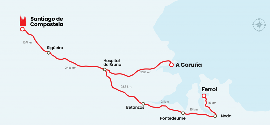
Times mean that neither the merchant bound by pilgrims lift their anchors in the south of England, nor the ports of the Arctic Gulf receive ruthless and wobbling pilgrims. Currently, the English Way is a very different reality, a terrestrial route that departs from Ferrol, almost exclusively, and from A Coruña. The Dársenas ferrolanas have eclipsed the prominence of the Herculean port, coming to less in Jacobean terms because the 75 kilometers that separate it from Santiago are not enough to obtain the Compostela. Both pathways were transited assiduously. This is borne out by the chronicles of the walkers and the reference to the different hospitals of medieval pilgrims, such as those of A Coruña, Ferrol, Neda, Pontedeume, Miño, Paderne, Betanzos, Sigrás, Bruma and Poulo, from which there are modern samples or successors.
One of the modern parents of this route, recovered in 1991, is Nedense Manolo Grueiro, who has provided us with innumerable information for the preparation of the guide and who has even walked with us for several stages. The establishment of the route and its recovery was possible thanks to the joint task of people and municipalities. Using documentary sources - chronicles of Sarmiento, Vales Villamarín, Vázquez Rey - they developed hard fieldwork, disseminating it later. In a couple of decades the hundreds of pilgrims who passed it in the first few years have become thousands. In the Holy Year of 2004, reviewing the statistics produced by the Pilgrim's Office of Santiago, it was visited by 3092 people. In 2010, also Holy Year, it was 6442, more than double. And in 2013, without being a retirement year, only until September had more than 4,000 pilgrims gone.
Between Ferrol and Santiago de Compostela, the route followed is 122 kilometers. We recommend, if the days allow, also to travel the 34 kilometers of the A Coruña section. Both roads are made only at the gates of Bruma Hospital. From Ferrol are the concellos of Ferrol himself and those of Narón, Neda, Fene, Cabanas, Pontedeume, Miño, Paderne, Betanzos, Abegondo, Mesía, Ordes, Oroso and Santiago. The one from A Coruña passes through the capital and through the ones from Culleredo, Cambre, Carral, Abegondo and Mesía, where he joins the itinerary of Ferrol.
The Camino runs during the first days through the natural region of As Mariñas Coruñesas, where the Rías de Ferrol, Ares, Betanzos and A Coruña form the Arctic Gulf, the magnus sinus artabrorum cited by the Romans. The journey of the pilgrims crosses the mouth of the rivers Xubia, Eume, Lambre and Mandeo, already in Betanzos, surrounded by a landscape that exhibits at the same time samples of the Galician coast with the lush interior. Then, as pointed out by María Pilar de Torres Luna in Los Caminos de Santiago and the Geography of Galicia, in a few kilometers you pass from the sea level to 400-500 meters, which you have to go out of the Mariñas and enter the Terra de Ordes, crossing the homonymous municipality and that of Oroso. Thanks to the proximity of the sea temperatures are smooth throughout the year, as María Pilar de Torres pointed out. There are no rough and long winters and frost are unknown, and summers are not characterized by scorching fire either.
Signalling:
The English Way and the other Jacobean routes in Galicia are the English Way. Of the two sections, the one that floats the most is the one that comes from A Coruña, the least traveled but not the least important. Without being bad, the signs have some conflicting points, especially in the capital itself and in El Portazgo (Concello de Culleredo). In addition, arrows already bleach at some points. In the case of the jones, some will need a replacement or rehabilitation. Of course, there is a shortage of the tablets that point to the distance, as they continue to be the suvenir most appreciated by pseudopilgrims. The Ferrol–Santiago section is much better marked and the exit of Ferrol is the only one that can pose problems, especially the beginning. As in the other, it doesn't add up to a review of the jones, some of them split, and a repainted arrows.
Hostels:
Seven public and six private hostels, pull this northern route to serve this route still unknown by many, but with great attractions for the pilgrim. We had to wait almost two decades, until 2010 and 2013, for the opening of hostels in Pontedeume and Betanzos to be set aside, which would have to have opened them years before. Every time a new hostel opens, the number of pilgrims automatically increases. It is a simple mathematical operation in which a large part wins and in which it continues to be suspended. Still, Sigüeiro, the last service population before Santiago, remains the most needed point on the English Way.No municipal hostel for pilgrims, although with three private hostels and sufficient hotel offer to answer the lack of such municipal hostel.
Bibliography:
Itinerary da Ruta Xacobea Camiño Inglés, work by Manuel P. Grueiro. The texts and plans, which include extensive fieldwork, were edited by Concello de Neda.
The paths of the sea to Santiago de Compostela, a work signed by Feliciano Novoa Portela and Pilar Ramos Vicent, with preface by Francisco Singul. Published in 2010 by Lunwerg S.L. and Ministry of Defence.
English Way, edited by the Xunta de Galicia on the occasion of the Xacobeo 2010, with texts by Francisco Singul.
The English Way by Alicia Carrera Gómez, edited by A Nosa Terra.
Denmark Jacobea, Vicente Almazán. Edited by the Xunta de Galicia on the occasion of the Xacobeo Year of 1999.
The pilgrimages to Santiago de Compostela, written in three volumes by Luis Vázquez de Parga, José María Lacarra and Juan Uría Ríu. A facsimile edited by the Department of Education and Culture of the Government of Navarra was consulted in collaboration with Iberdrola of the edition published in 1948 by the Superior Council of Scientific Research.
The Jacobean Pilgrimages, written in three volumes by Luciano Huidobro and Serna and several collaborators, first published in 1950 and 1951. The edition made by the Provincial Council of Burgos and Iberdrola on the occasion of the Holy Year of 1999 was consulted. In volume III, in the Secondary Roads section, he dedicates several pages to the Camino from A Coruña and Neda to Santiago.
The Camino de Santiago and the Geography of Galicia. Routes, Landscapes, Comarcas, by María Pilar de Torres Luna. Edited by the Xunta de Galicia on the occasion of the Xacobeo Year of 1999.