Article translated by an automatic translation system. Press here for further information.
Stage from Valdesalor to Casar De Cáceres
The ascent to the port of Camellas allows you to discover and reach Cáceres
Information about the stage 11: Stage from Valdesalor to Casar De Cáceres

Enlarge map
Points of interest in the stage 11: Stage from Valdesalor to Casar De Cáceres
The route
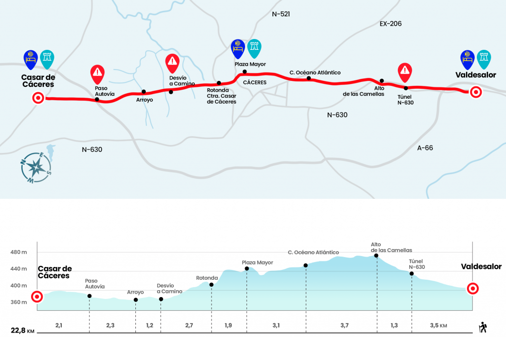
- Km 0. Valdesalor(Hostel. Bar. Store. Office. medicine chest)
Taking as a reference the N-630, we walked left until we reached the height of the restaurant and the gas station. At this point we cross the road and continue along the path to the right of the National. So we got to a section of asphalt to save the highway by a bridge. We follow the path – the N-630 on our left – and two kilometers later we pass through a tunnel under the National Highway (Km 3.5). Now, with the National on the right, we are progressing in comfortable ascent through a loose stone road that leads us to crown the Puerto de las Camellas. Here, at an altitude of 482 meters, a war fence near the grounds of the Santa Ana military camp (Km 4.8).
We crossed the N-630 for the last time and after a slight echo we spotted the city. In three kilometers we enter Cáceres through the Atlantic Ocean Street, where dozens of small workshops are located (Km 8.5). Later we crossed the EX-206 and followed the endless San Francisco Round (as a reference we will go with an Institute, the Provincial Court and the San Pedro de Alcántara Hospital). We reached the roundabout of the Plaza de San Francisco and at the gates of the historic center, declared a World Heritage Site in 1986. An alternative to reach the center is to climb the streets San Ildefonso, Plaza Santa Clara and Puerta de Mérida. After going down the Adarve of Padre Rosalío and the Adarve Santa Ana we went under the Arc de la Estrella and finally accessed the Plaza Mayor.
- Km 11.6. Caceres(All Services)
Although there are still more than 11 kilometers left for the Casar de Cáceres there is enough time to visit its historical complex and replenish forces in one of the terraces of the Plaza Mayor. Like Merida, Cáceres deserves a quiet visit that is worth a overnight stay. He leaves the city through the streets Gabriel and Galán and the Plaza del Duque, where he turns left by General Margallo to reach the Plaza de Toros leaving this to our right. The monument to the Laundries is left behind and then a pedestrian crossing by the road. We thus reached a roundabout to continue through the CC-38. (km 13.5)
A repecho will open before us a long line of unwooded asphalt for which we will advance two and a half kilometres. Thus, between kilometric point 3 and 4 of this track, a yellow arrow on the tar diverts us to the left to link to a road (Km 16.2). An hour later – we can find some areas with water or mud – we pass under the bridges of the highway (Km 20,7) and the link of the round to outline another line that will take us to the entrance of the Casar. There is only one pedestrian walk between palm trees and the Calle Larga Alta of the town to reach the City Hall and the hostel.
- Km 22.8. Casar de Cáceres(All Services)
The difficulties
Remarks
In images
What to see, what to do
The hostels

¿Do you want to send any photo of "The Camino de Santiago"?
If you have any photos of "El Camino de Santiago" that you want to share with us, you can send them to us and enlarge the photo gallery


Forum: What pilgrims think about the Camino de Santiago
See all