Article translated by an automatic translation system. Press here for further information.
Step from Casar De Cáceres to Cañaveral
It advances through the Cacereña plateau to the beautiful Alcántara reservoir
Information about the stage 12: Step from Casar De Cáceres to Cañaveral
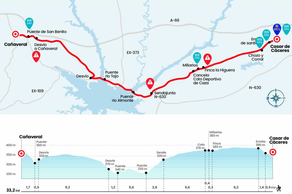
Enlarge map
Points of interest in the stage 12: Step from Casar De Cáceres to Cañaveral
The route
Km 0. Casar de Cáceres (All Services)
Along the streets Larga Alta and Larga Baja we pass by the chapel of Santiago to leave the population. By piste we arrived by a path that was born and deviated to the left. There is a yard and a stone hump with brick tile used as a resting by pastors and transhumance cattle (km 1.9).
We will continue on the same track we bring, well signposted by a granite block. Between this point and the first cancel of the stage mediate seven kilometers of flat and rectilinear outline that will allow us to enjoy the landscape. Among stone muretes, with the presence of numerous cattle farms and granite batolites, we will enjoy a beautiful landscape, only private in the frequent days of winter fog. So, after about an hour and a half, we will go next to the finca La Higuera and then we will see several miliaries on our right - next to the fence - to open the cancel of the sporting hunting ground (Km 8,8).
Six hundred meters later, we will open another path and advance along a more blurry path that progresses between retamales. In the next two kilometres there will still be another cancelling with one livestock vessel and then two more. The day continues between walls and matas of retama throughout the places of Las Condesas and Los Baldida and passes by a house. In nine hundred meters we will reach a couple of cement posts and continue in front, descending to a Canadian step, already next to the N-630. We do not go down the road but turn right on a path that winds up and down above the National (Km 14,4).
Finally it ends down to the same road, almost to the height of the kilometric point 525. On the arcén we will save the course of the Almonte River - one of many that receives the Tagus and that form the extensive reservoir of Alcántara (Km 16,7). Three quarters of an hour later we will do the same on the river Tagus (km 20,5). In a moderate ascent we left the entrance to the Nautical Club and reached the diversion to the hostel of the Reservse of Alcántara, located in a privileged natural environment.
Km 21.7. Alcántara Dam Hostel
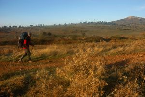
Those who continue the stage will leave the road through the right shoulder. At this point is born an ascending road that surrounds the Garrote Hill, 374 meters high, and that allows to see an excellent panorama of the reservoir and its surroundings. In the vicinity of this watchtower, in Iter ab Emerita Asturicam, El Camino de la Plata - excellent doctoral thesis by Roldán Hervás -, the well-known historian shuts down the situation of the mansio Turmulos. Arriving at a Canadian step, the profile becomes flatter and places us on a plateau from which the peak of Silleta is already seen. On the hillside of the mountains sits Cañaveral, still seven kilometers away.
Crossing the large plateau is easy except for the loose stone that floods our way. After a Canadian step we will surely see one of the first black bovine herds and sharp, albeit harmless, horns. Two and a half kilometers later a wooden sign announces the diversion to Cañaveral (Km 30.5). The road, for those who wish to continue towards Grimaldo without visiting Cañaveral, goes ahead and reaches the Cañaveral station. Here he takes a road to the N-630 and continues along the way by the chapel of San Cristobal. To reach Cañaveral we bet on the diversion and we go down to the medieval bridge of San Benito (Km 31). It only remains to climb the N-630 to access Cañaveral. Yellow arrows, on the left of the road, direct the pilgrim through the streets Monrobel, Church Square, Downtown and Real.
Km 33.2. Cañaveral (Hostel. Hostels. Bars. Store. Cashier. Pharmacy. Office)
The difficulties
Remarks
In images
What to see, what to do
The hostels

¿Do you want to send any photo of "The Camino de Santiago"?
If you have any photos of "El Camino de Santiago" that you want to share with us, you can send them to us and enlarge the photo gallery
Forum: What pilgrims think about the Camino de Santiago
See all