Article translated by an automatic translation system. Press here for further information.
Stage from Montemayor Baths to Fuenteroak de Salvatierra
We say goodbye to Extremadura and salute Castilla for Béjar
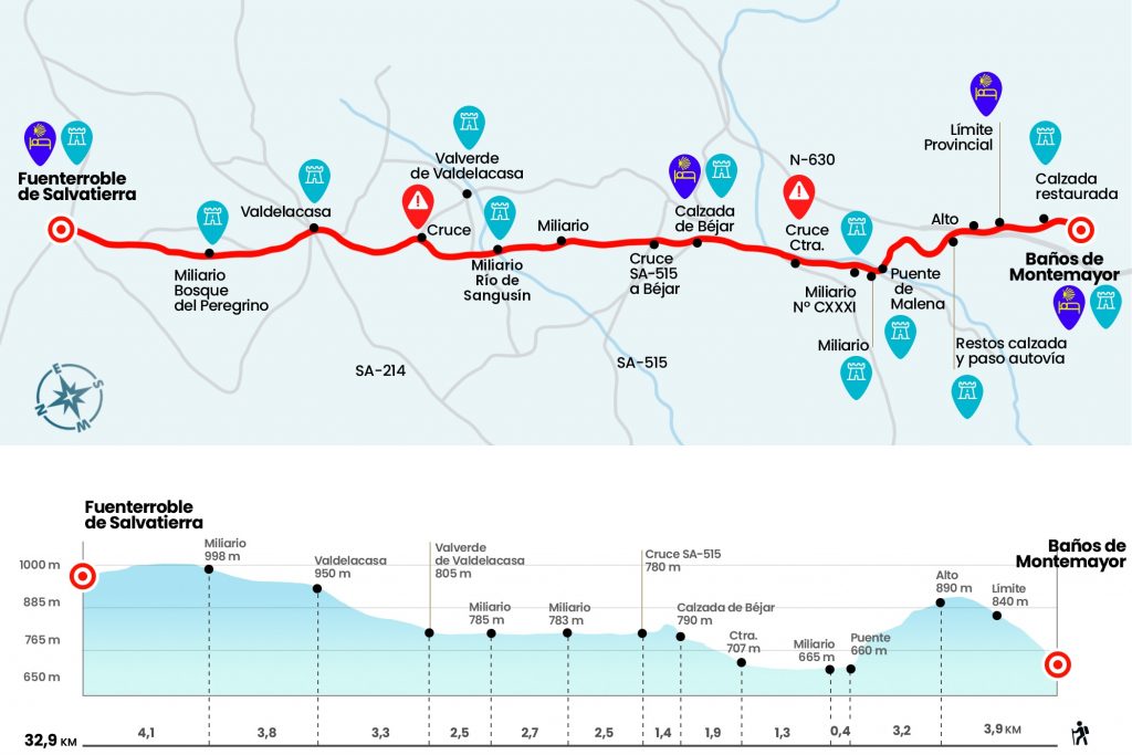
Information about the stage 16: Stage from Montemayor Baths to Fuenteroak de Salvatierra
Enlarge map
Points of interest in the stage 16: Stage from Montemayor Baths to Fuenteroak de Salvatierra
The route
- Km 0. Baths of Montemayor (All Services)
There is no better start than to face the climb to Port of Béjar through the section of the Roman road that flows to the exit of Baños de Montemayor (km 0,6). It was restored in the 1970s and, according to some author, with little success. Hold or not your essence the climb is nice, avoiding the asphalt and the turns and revolts of the N-630. In full ascension there is a stone fountain with the inscription Cañada Real Aliste Zamorana or de la Plata, a fact that also claims the passage of this pecuary path.
We pass the fountain and the road is over, forcing us to cross the national and continue on a road that moves on the left.
- Km. 2. Port of Béjar (Salamanca)
It is at this point that we say goodbye to Extremadura and enter Castile through the province of Salamanca. The path returns us back to the road and through it we reach the high. A gas station, the veteran Casa Adriano and the Station neighborhood, with an included hostel. The change of landscape is spectacular and apothetical, because before the eyes of the pilgrim arises now, upon arriving in Puerto de Béjar, a panorama of authentic privilege, being its natural heritage distinguished as Natural Park of Candelario (1992), Reserva de la Biofera (2006), Jardín Botanico BIC (2006), Red Natura 2000 (2015) Camino Natural or Via Verde (2018)
We left the N-630 on the left and passed under the highway bridge, where the works discovered another section of road that some have labeled as non-Roman (Km 3,9). Later there is a recreational area and the reproduction of the miliary CXXXII. It was supposedly in this place, 132 miles from Mérida, where the mansio Caecilio Vico was settled, although there is also disparity of opinions and some authors place it in Baños de Montemayor. We go down the road to the bridge of Magdalena or Malena, which we cross to save the river Men's Body (Km 7.1).
A few meters a miliary rises and then we will see a corral on the right hand, keep one of the best preserved miliaries of the whole Vía. This is number CXXXIV (Km 7.5). After the visit we enjoyed a stretch of three kilometers by the river, until we reach the road (Km 10,7) and link again to the old road, through which we climb to Calzada de Béjar.
- Km 12.7. Béjar Road(Hostel. Bar) •
The hermitage of the Humiliadero welcomes us to this small town, of right name and that we go through to the plaza, where is the church of the Asuncion and where we can admire a sample of the most typical Serbian architecture. We left the village to plains for six kilometers through the Sangusin Valley. On the left, in the distance, the Batuecas and the Sierra de France. On the right, the saws of Béjar and Candelario. The tour is marked by several miliaries. Among them is the number CXLII, which is once again located on the banks of the Sangusin River after its journey as a decoration in the Ministry of Public Works (Km 19.2). We went out to the asphalt for a short distance and took a road that will take us to Valverde de Valdelacasa, in which term the mansio ad Lippos should be located.
- Km 21.7. Valverde de Valdelacasa(Hostels. Bar)
Here are some cruises and the church of Santiago. Let us not delay crossing Valverde de Valdelacasa, which looks at some Jacobean sculptures, to take the road that leads us, ascending, to the following population:Valdelacase, where we reach 950 meters of altitude.
- Km 25. Valdelacasa(Bars. Shops. Posada del Peregrino)
We left the village and then left the asphalt on the left. Let's complete the last six kilometers of the day between Robledales. There will still be time for more surprises, such as the one given to us by the miliary CXLVIII, replacement in the baptized as Peregrine Forest (Km 28,8). We have yet again returned to the road to finally reach Fuenteroak de Salvatierra.
- Km 32.9. Fuenteroak de Salvatierra(Hostel. Casa Rural. Bars. Shops)
The difficulties
Remarks
In images
What to see, what to do
The hostels

¿Do you want to send any photo of "The Camino de Santiago"?
If you have any photos of "El Camino de Santiago" that you want to share with us, you can send them to us and enlarge the photo gallery
Forum: What pilgrims think about the Camino de Santiago
See all