Article translated by an automatic translation system. Press here for further information.
Stage from Parra to Montemayor Baths
Last day in Extremadura through the Ambroz valley. To rest
Information about the stage 15: Stage from Parra to Montemayor Baths
Enlarge map
Points of interest in the stage 15: Stage from Parra to Montemayor Baths
The route
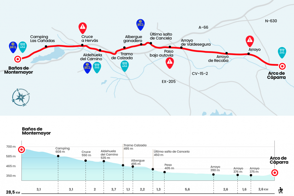
- Km 0. Parra (Interpretation Centre)
We left the Roman city of Cáparra trying to retain in memory the last vision of the arch. In a few hundred meters we crossed the road heading to Guijo de Granadilla and entered a path. Thus, with greater comfort, we advance through the dehesa Casablanca , surrounded by a natural environment worthy of the best postcard. In the long run, Castile awaits. As yesterday, several streams of unpredictable flow will cross our way. They are responsible for testing our balance, as they have to be drawn by jumping between the granite blocks arranged as a bridge. At five and a half kilometers, irremediably, we will reach a paved runway. It's the Ambroz service road. If we want to step on soft ground we can walk in the countryside, parallel to the road (Km 5.5).
There is no other song possible in the next 7 kilometers remaining until you reach under the highway and national bridge. The service road vadea the stream of Valdesegura (Km 6,8) and converges for a short stretch with the road of Casas del Monte (Km 9,7). It finally reaches the step under A-66 and N-630, next to the Grande Throat, which is sometimes necessary to wade (Km 12,4).
At this point we may lose any indication. If you look across the N-630, you'll see a large meadow and, in the middle, a yellow arrow painted on a pole of the electric line. We take this road right hand to in less than 2 kilometers turn left on a dirt track between cattle, is the Cañada Real de la Vizana , which follows the trace of the Vía de la Plata. Two kilometers later we passed by to a breeding hostel (Km 15,9). A short stretch of climb through the remains of the old road (Km 17) takes us to a house, where we turn left following the signs of a handmade poster. We walked under the highway and lined the line to Aldeanueva del Camino.
At the entrance of this town we receive a great ceramic decorated with the names of all mansions of the Vía de la Plata.Aldeanueva is the most central locality in the Ambroz region and, in addition to conserving large samples of popular architecture, has two parish churches.Our Lady of Olmo in the north and San Servando in the south remember past times, when the population was divided by the kingdoms of León and Castilla and by the dioceses of Coria and Plasencia.
- Km 19.2. Aldeanueva del Camino(All Services)
In the middle of Aldeanueva crosses the throat of the Buitrera, whose course we saved by a bridge to access the Plaza del Ayuntamiento. We left the village and went to N-630 at the height of kilometric point 437. After a roundabout, we went over the highway to return to the national and continue on its strength. We will leave to the right the crossing to the town of Hervás, which retains one of the best juderías in Spain. From this point there are more than 4 kilometers to the center, although the visit is recommended (Km 21.2).
It will be eight finals and boring kilometers in slight ascent to Baños de Montemayor. Half an hour from the crossing to Hervás we pass by the Camping Las Cañadas (Km 24,3). From this point we will only leave the N-630 once and it will be a little before arriving at Baños to tread a few hundred meters of road.
- Km 28.5. Baths of Montemayor(All Services)
The difficulties
Remarks
In images
What to see, what to do
The hostels

¿Do you want to send any photo of "The Camino de Santiago"?
If you have any photos of "El Camino de Santiago" that you want to share with us, you can send them to us and enlarge the photo gallery
Forum: What pilgrims think about the Camino de Santiago
See all