Article translated by an automatic translation system. Press here for further information.
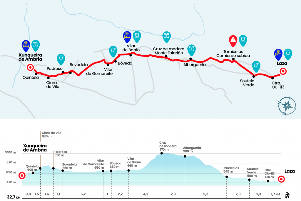
Stage from Laza to Xunqueira de Ambía
Ascension of Monte Requeixada to Alberguería with strong slopes
Information about the stage 8: Stage from Laza to Xunqueira de Ambía
Enlarge map
Points of interest in the stage 8: Stage from Laza to Xunqueira de Ambía
The route
- Km 0. Laza(Hostel. Pension. Bars. Shops. Pharmacy)
From the hostel we descend to a alley located next to the church of San Xoan. We arrived at Praza da Picota and lined the street that leads us to pass by a cruise and that reaches the foot of the OU-113 (km 1.7). We took it and at 800 meters, in the diversion to Vilamea, we left it momentarily to cross the Támega River. The asphalt is taken back to the first population:Soutelo Verde. To date, he called attention to a sign with the inscription “Granada 888”.
- Km 4. Soutelo Verde
We cross the population to go back to the road, which we then left followed by a trail that leads between growing plots to Tamicelas.
- Km 6.9. Tamicelles
Next to the 18th chapel we turn left and climb a paved path that soon becomes a carpeted path of pine needles. After the first crossing begins the hardest section and at each step we are gaining altitude by the steep slope of Mount Requeixada. The gap is constant during the first mile and a half, but then it attends a little. The ascension is quite long in the final part, where we see clearly, at the bottom left, the road we have left in Soutelo. We retake it in the upper (Km 11) to enter Alberguería. Here, under the name of El Rincón del Peregrino, Luis Sande runs a hostel with 24 seats and also a bar decorated in all its corners by the vieiras signed by the pilgrims.
- Km 12.2. Swimming pool(Hostel. Bar)
He leaves the village on a comfortable herbose path, which is usually watered with ease, and after a kilometer long we cross a road to return to the road and then to the OU-113. We cross it to take another path that leads us to a wooden cross located on Mount Talariño. It is located at 970 meters altitude, the highest level of this day (Km 15.1). We continue to descend until we reach the OU-113 road which we follow shortly after leaving it on the left and so we decisively start the first descent by paved runway for later by land until we reach the OU-1104 road which we follow until Vilar de Barrio.
- Km 19.3. Vilar de Barrio(Hostel. Bars. Shops. Pharmacy)
We cross this municipality passing by the church of San Pedro Fiz and continue by road towards Vault, parish to which we arrived after a kilometer and a half. It is evident here that the change of landscape and the relative proximity of capital completely affect the way of life of the population. Forgotten the mountain villages, we find more inhabited towns, less stubborn architecture and dedicated to agricultural tasks. This is also shown by the early Hórdia.
- Km 21,5. Vault
We crossed Vault and then arrived to Vilar de Gomareite (Km 22.5). We go off the paved runway and half a kilometer we turn left to catch another runway. It transits through a natural wetland already dried in the 1950s. The line has a length of three and a half kilometers. We will finally turn right to reach Bobadela.
- Km 27.7. Bobadela
More horrors and the incombustible Galician berzas cultivated next to the houses. We leave Bobadela on a path that goes up to the right hand and moves between a mass of oaks. He then moves left and crosses a road to enter Padroso (Km 28,8). It leaves by the Cairn marking 133,077 to Santiago and immediately after a water pylon you have to turn left hand. We go up, we cross a somewhat wider road and we come a step between a few corners. We pay attention to the descent and continue along a path along a small row of eucalyptus that give way to Cima de Vila.
- Km 30.4. Cima de Vila
We turn right without just contacting the core and we go out on a path that leads to cross a track and to continue forward. We cross a road, we pass by a ship and we continue to descend to the following population:Quintela (Km 31.9). Already by road we take the diversion from the right to the pilgrim hostel, to which we arrived in 600 meters.
- Km 32.7. Xunqueira de Ambía(Hostel. Bars. Shops. Pharmacy)
The difficulties
Remarks
In images
What to see, what to do
The hostels

¿Do you want to send any photo of "The Camino de Santiago"?
If you have any photos of "El Camino de Santiago" that you want to share with us, you can send them to us and enlarge the photo gallery
Forum: What pilgrims think about the Camino de Santiago
See all