Article translated by an automatic translation system. Press here for further information.
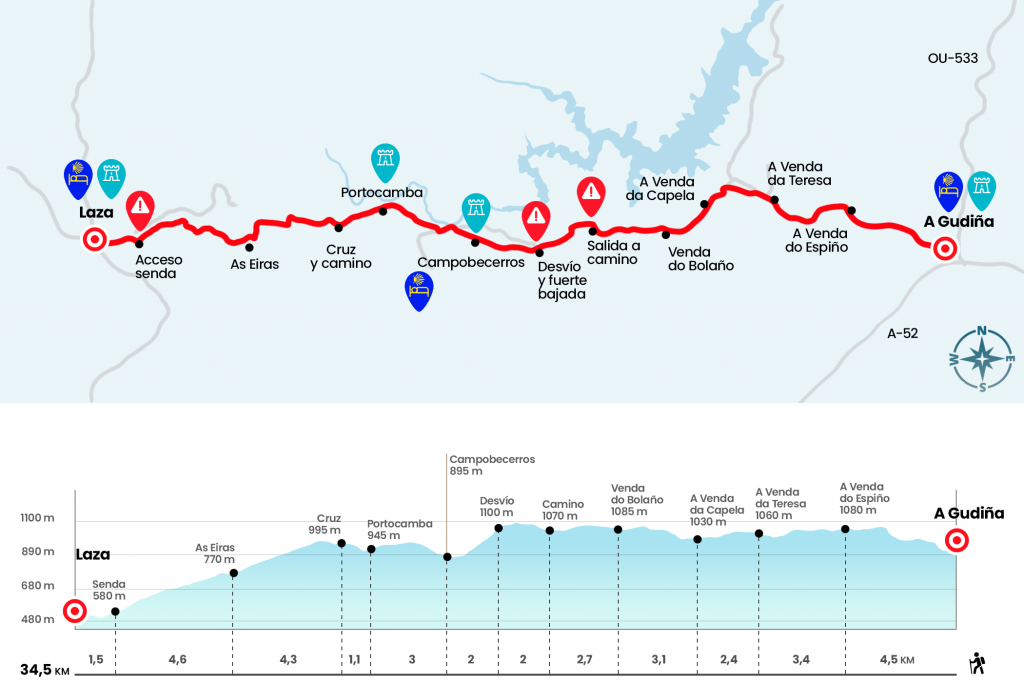
Stage from A Gudiña to Laza
Please bring food because there are only services in Campobecerros
Information about the stage 7: Stage from A Gudiña to Laza
Enlarge map
Points of interest in the stage 7: Stage from A Gudiña to Laza
The route
- Km 0. A Gudiña(All services)
We passed, as yesterday, under the train tracks. Instead of going out to the N-525 we turn right by the Major Rua and follow it to the Major Praza, where there is a cruise and a Jacobean mojón with two vieiras. The one on the left, longer alternative, proposes to continue towards Verín. The shortest right wing towards Laza. In our guide we will choose to continue the pilgrimage for the latter. In this way we follow to the right by the rustic Cima de aldea, a street that ends on the road of the old Verea Vella and for which we will stay in the Serra Seca. We continue through the arcén the next 3
kilometers to the first town of the day, A Venda do Espiño.
- Km 4,5. A Venda de Espiño
Another 3 kilometers of monotonous arcén take us to A Venda da Teresa, where the rural depopulation becomes more evident, even more so in this environment located over a thousand meters altitude.
- Km 7.8. A Venda da Teresa (Source)
We leave behind the last slate roofs and go down a road that in a few hundred meters goes to find a slightly wider track. Here we have the first view of the As Portas Reservoir, built in 1974 in the gorge formed by the Camba River. The runway flows into the road, which leads us to pass over the train tracks. In this way we enter the Concello de Vilariño de Conso, specifically the Venda da Capela.
- Km 10.2. To Venda da Capela
After passing the core we take a rising path to the left hand that dies again in the asphalt. In the same spirit, after a kilometer and a half, we reached the population of Venda do Bolaño, another nucleus abandoned to his fate.
- Km 13.3. A Venda do Bolaño (Source)
We continue along the road for another two and a half kilometers and we go down a road that ascends next to the left shoulder, (see here and ignore an arrow that tells us to follow the road, although this also goes to Campobecerros). Later it becomes a runway through which we advance until a Jacobean milestone encourages us to “pull us” down, (currently the arrows indicate to continue on the road, in any case, downhill slope or road, we have to descend with caution), by a path covered with slate that descends rapidly to Campobecerros, the village of Concello de Castrelo do Val and Seca de la Fin.
- Km 20. Campobecerros (Private hostel. Bar-Shop. Bar-Restaurant. Tavern. Pension and Rural Accommodation)
We go through this locality, the only one that seems like this world, and where we can supply ourselves, to get off the road, which we continue on the left. A total of 3 kilometres between upward and downward leave us at the gates of Portocamba, another almost forgotten village where a few neighbours still cling to more sincere ways of life remain.
- Km 23. Portocamba
We abandon this stronghold of the past and reach a wooden cross, where a sculpture of Carballo invaded by stones encourages us to take the slope of the left (Km 24,1).
A first tranche of false plain happens the descent decided by the rope of the mountain, with the cut to our right. For more than 3 kilometers does not change the script and we can enjoy the spectacular views of the valley. We arrived at the village of As Eiras, of the Concello de Laza.
- Km 28.4. As Eiras (Pilgrim Support Point of the Ultreia Association – As Eiras)
We cross the population and rise to the level of a grassland equipped with a fountain, tables and wooden benches. At this point we cling to the only possible option, a mountain road for which we go down for 4.5 kilometres. Once we tour we will see a Jacobean Mojón (brand 163,139 to Santiago) that leads us to cross the Cereixo River. We reached the OU-112 road to enter Laza. The route to the hostel, which is located in the rua do Toural, is well marked and once in the population we still have to walk another kilometer.
- Km 34,5. Laza(Hostel. Pilgrim Support Point. Pension. Bars. Shops. Pharmacy)
The difficulties
Remarks
In images
What to see, what to do
The hostels

¿Do you want to send any photo of "The Camino de Santiago"?
If you have any photos of "El Camino de Santiago" that you want to share with us, you can send them to us and enlarge the photo gallery
Forum: What pilgrims think about the Camino de Santiago
See all