Article translated by an automatic translation system. Press here for further information.
Step from Lugo to San Romao da Retorta
Melide is a point of convergence with the French Way. Enjoy it!
Information about the stage 10: Step from Lugo to San Romao da Retorta
Enlarge map
The route
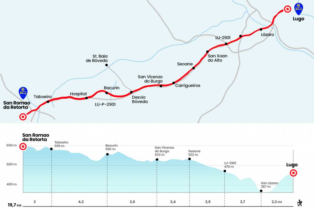
- Km 0. Lugo (All services)
We leave the rustic das Noreas and turn right to tour the rustic San Pedro. Just before we reach the Plaza Mayor we pass by the parish of Santiago, the former conventual of Santa Maria. We cross the Plaza Mayor (under the stands there are several cafes that open early), where the City Hall stands, beautiful baroque construction of 1738. At the bottom of the Plaza we lower the staircase of the Poet Luis Pimentel and access the Plaza de Santa María. The Episcopal Palace and the Cathedral of Santa Maria are raised here. Its construction began in 1129 but many later additions from the 14th, 16th and 18th centuries gave the primitive Romanesque temple its baroque and neoclassical figure. We continue from front glued to the cathedral, choosing to leave the enclosure walled by the door of Santiago or the door of the Poststigo, with which the Roman work already counted. It should be noted that from the cathedral the vieiras also lead the itinerary to the Miñá gate, which was the original, as near it was the hospital of San Miguel (km 0.6).
Past the door of Santiago we descend through the rustic Santiago and a little further down the stairs of the Ponte Road. We passed under the Ronda del Carmen and then under the N-VI to quickly reach the 1st century Roman bridge over the Miño. Crossing the 19th Roman Road of the Antonino Itinerary, which joined Lucus Augusti with Bracara Augusta, was very successfully rehabilitated in 2013. The hostel Roots & Boots (Km 1.5) is located next to the bridge. At the exit of the bridge we turn right through the Vella da Ponte and the Fermín Rivera, enjoying the views of the river, whose margins are packed with elbows. Thus we arrived next to the fountain and chapel of San Lázaro and where the leper hospital was located, also called lazaretos or malaterías.
- Km 2.3. San Lázaro (Bars)
At the top of the 100.96 kilometers, we turn left and start with an urbanization the rise to the top of Louzaneta. The descent continues along the local track to the N-540, which we saved by a tunnel (Km 3.9). We crossed the Louzaneta urbanization to later cross the LU-232. As we leave the crossing we take the LU-P-2901 in the direction of Burg, San Román and Palas de Rei. Route that will be our guide in these two stages that follow (Km 5).
To avoid the asphalt we take advantage of the path that advances in the right arch. We leave to the right Santo Matías, of the parish of O Veral (just over half a kilometer, also on the right hand, is the Castro de Rebordaos) and we continue through the dominions of the parish of San Xoán do Alto to Seoane, which houses its parish church, visible a few meters from the road.
- Km 7.5. Seoane
We continue the journey through the lands of the Mera, accessing the parish of O Burg by Carrigueiros, with its pazo known as Casa Grande de Carrigueiros (Km 9). A short distance from this is the chapel of St. Bartholomew do Burg. Half a kilometer later we passed the Ribicás Fonte and climbed to San Vicenzo do Burg. Bar As Searas (have some triptych about visits to Santa Baia de Boveda) is on the right hand, 100 mt from the Camino. Also the church, baroque of the 18th century, which deserves a visit.
- Km 9.9. San Vicenzo do Burg (Bar)
The LU-P-2901 remains a faithful companion. Without a parallel path, it's just paved. We entered the parish of Poutomillos and left the diversion to Santa Baia (Sta. Eulalia) de Boveda (Km 11,8). It is a shame that it is not closer to the Camino. It is a temple or place of late Roman baths with mural paintings of the time that was discovered in 1926 under the parish church of Vault. Probably a place of worship for the goddess Cibeles.
Look! Because 900 meters after the diversion to Santa Baia (it's easy to pass it when you're on the left shoulder) you have to leave the road on the right. Blessed is the shadow of these congolese, the first from Lugo. We saved Mendo’s regate and entered Bacurin, located at the foot of a castro.
- Km 13.5. Bacurine
Half a kilometer later we can deviate from the Camino 100 meters to the right to see the Romanesque church of San Miguel. Already mentioned in 1160 is located next to the pazo of the same name. Under the cover of the shadowy sliding, we will end a bit later on the road. The itinerary now travels next to the house of O Paso and Hospital, places of the Lucense parish of San Pedro de Mera. In 87,161 km to Santiago we left the road right returning to it right away to pass San Pedro de Abaixo and reach Taboeiro.
- Km 17.7. Taboeiro (Mesón traditional Galician food 250 mt in the diversion to Growing)
We passed the detour to Growing and continued without loss on the road to the church of San Romao da Retorta. We are already at the Guntin Concello. To go to the hostels in San Romao, there are both the Xunta and a private one, you have to turn right. Surrounding the church we will reach the center, with bar and sale of some groceries.
- Km 18.8. San Romao da Retorta (Taberna)
After the reply of the miliarian, we crossed a road and stood in a few minutes by the hostels, located in the place of Castrelo.
- Km 19.7. Castrelo (Hostels)
The difficulties
Remarks
In images
The hostels

¿Do you want to send any photo of "The Camino de Santiago"?
If you have any photos of "El Camino de Santiago" that you want to share with us, you can send them to us and enlarge the photo gallery
Forum: What pilgrims think about the Camino de Santiago
See all