Article translated by an automatic translation system. Press here for further information.
Balearic Islands to Lugo
The traveler can almost see Lugo. Roads without any difficulty
Information about the stage 9: Balearic Islands to Lugo
Enlarge map
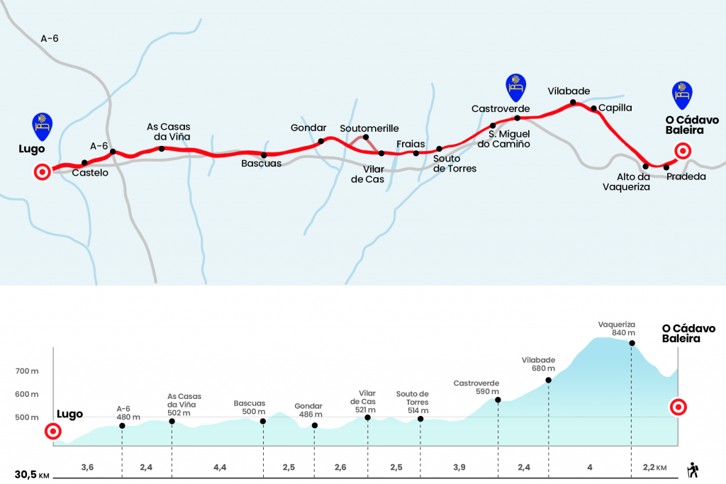
The route
- Km 0. O Cádavo Baleira(All services)
The last steps through O Cádavo lead us to the square behind the Casa del Concello, which we access by stairs. Leaving to the right the diversion to Perrelos and Touzón, we took the neighborhood track on the left that goes up to Pradeda, the place of the parish of San Pedro da Esperela (Km 1,1). From Pradeda we have a good image of O Cádavo, located under the Campo da Matanza. The runway turns on a dirt road that, after a good hill, plants us at the foot of the LU-530, where we crowned the high da Vaqueriza (Km 2.2).
- Km 2.2. Alto da Vaqueriza
We do not enter the road, but we continue on the right of it by a forest track. About 400 meters from the road we have a bifurcation between the old road we described below, now called "complementary road" and the official road that goes from this point to Castroverde passing through Vilalle. This now official road by Vilalle is 500 meters shorter than by Vilabade but it prevents us from observing a jewel of the road like the Gothic church of Santa Maria de Vilabade, so below we recommend and describe this option. Here the Xunta mojón brand 131,636 kilometers to Santiago. Just over a kilometer later, next to the Cairn of 130,496 kilometers, you get a magnificent view of the Chaira, the plain or plateau lucense where its capital unfolds. This smooth and gentle tour of the Cornedo, Fonteseca and Vilabade mountains leads to the Carme Chapel. Its fresh water source and the merendero are an excellent claim to stop the march (Km 5.3). We descend by paved runway to Vilabade, parish already belonging to the Concello de Castroverde. Its Gothic church dedicated to Santa Maria is known as the Cathedral of Castroverde and was declared a National Monument in 1979.
- Km 6.2. Vilabade
A local road brings us closer to the LU-530, right at the entrance of Castroverde. On the right side of the road is the hostel of pilgrims of the Xunta, which was opened in 2012. We cross the capital of Concello – in which the tower of the tribute of an old castle of the 14th century stands out – by the same LU-530 and turn left hand to visit the church of Santiago. At his feet is the fonte dos nenos and the City Hall.
- Km 8.6. Castroverde(All services)
Castroverde was the only population with services of the stage although later we will find several places with vending machines. After the Casa do Concello we took a path between chestnut trees and, after a bifurcation, we went down to the LU-530. We cross the road and turn left hand to pass a tunnel. By paved runway we descend to San Miguel do Camiño, leaving the church to our right (Km 9,9).
- Km 9.9. San Miguel do Camiño
Let us advance through the chaira lucense by meadows and roads of chariots, called in Galicia congostras, which are located between sebes or comaros covered by ferns and hihedrias. About 550 meters after crossing the Chamoso River, flowing from the Miño, we went off to a road and followed it a few meters in front. We then left it next to the left arches and immersed ourselves in another congolese. Two more streams give way to the church of São Tomé, prologue of the parish of Souto de Torres, to which we enter.
- Km 12.5. Souto de Torres
We traverse Souto in a south direction and back on the Camino we cross the Angueiro rego. Then we went to a paved runway and passed by Mesón de Fraias (Km 13.5). The most immediate parish is Santa Maria de Moreira, whose church is on the right hand. It is followed by several places in this parish, such as Nadela, after which we will see a photogenic cruceiro, and Vilar de Cas, something later.
- Km 15. Vilar de Cas(hostel)
At the exit there is the possibility of visiting Soutomerille and his church of San Salvador, a jewel of the restored prerogative during the baroque that still has a window of the primitive work in the apse. The rodeo is an additional 800 metres and you do not need to go back to this point but rather links a little later with the official route. It continues forward to a quarry in low hours and crosses the river Romeán, also tributary of the Miño, after passing the houses of A Pallota, the last entity of the parish of Moreira and the Concello de Castroverde (Km 16,5). We arrived at the LU-P-2917 and climbed through it to Gondar, the first parish of Concello de Lugo.
- Km 17.6. Gondar(Soft drink machine, coffee, snacks and sandwiches)
We continue to climb the road, by the place known as Cuesta Francés, to a quarry located on the upper. We started the descent, and about 200 meters we left the road on the right. Through the Camiño da Caciza we reached a runway, leaving Bascuas on the right hand. Next, look at the diversion!, turn right and follow a neighborhood track parallel to the LU-530, which advances about 80 meters to our left. After turning further to the left we took a forest track at the foot of the LU-530 and ended up plunging into it (Km 21.4). Progress must be made on the road 1.4 km, passing the Carballido estate and the river of the same name. Shortly after passing p.k 7 we take to the right the road heading to Manzoi and O Pondelo (Km 22,8). We left her on the left 250 meters later to get into a congolese. Through it flows the rego do Muiño, which we will cross to continue to As Casas da Viña, place of the parish lucense of Carballido.
- Km 24.5. As Casas da Viña(Bar a few kilometers)
The forces start to flap and the last part of the stage becomes eternal. At the exit of As Casas da Viña takes the witness a wide path. We will pass the indication to a bar located 300 mt and right next to the substation of San Cibrao. Almost glued is the North-West Highway A-6 (Madrid-A Coruña), which we saved above (km 26,9). The dirt track leads us to cross the east round in the vicinity of O Carqueixo. No later will we arrive at Castelo
- Km 28.4. Castelo
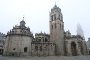
We go down to Chanca district, with its 29-meter high viaduct, where we cross the Rato River. We go up the Chanca Rua, where we see the 104,241 km to Santiago, and we pass under the train tracks. A little later we passed the stairs of Fontiñas and then we followed the ascent by the Carril das Flores, which we took next to the praza do Camiño Primitivo. We enter the Round of the Wall and enter it through the Gate of St. Peter, where we read: “Here came King Alfonso II the Casto in the ninth century, inaugurating the first road of Santiago.” The first street on the right hand is Rúa das Noreas, where the pilgrim hostel of the Xunta is located. Next to the Camino, at the exit of Lugo at the foot of the Roman bridge over the Miño, is the private hostel.
- Km 30.5. Lugo(All services)
The difficulties
Remarks
In images
What to see, what to do
The hostels

¿Do you want to send any photo of "The Camino de Santiago"?
If you have any photos of "El Camino de Santiago" that you want to share with us, you can send them to us and enlarge the photo gallery
Forum: What pilgrims think about the Camino de Santiago
See all