Article translated by an automatic translation system. Press here for further information.
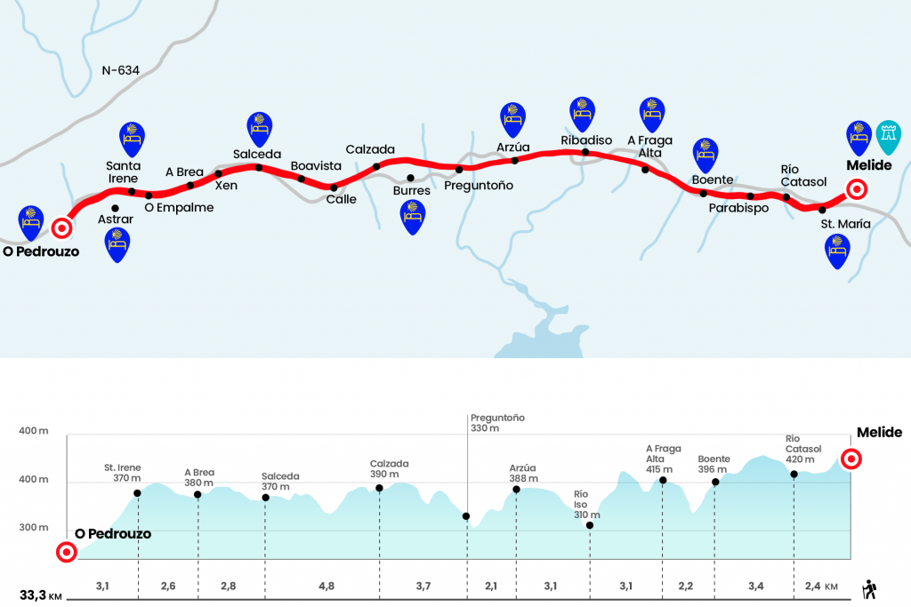
Melide to O Pedrouzo Stage
Compulsory visit to the old pilgrim hospital in Melide
Information about the stage 12: Melide to O Pedrouzo Stage
Enlarge map
The route
- Km 0. Melide (All services)
In the Plaza do Convento there is a quote from the old pilgrims' hospital, which today houses the Museo da Terra de Melide; the Convento del Sancti Spiritus and its church; the 18th century City Hall building and the Chapel of San Antonio, along with which we left the plaza to take the rustic San Antonio. After embroidering the public hostel we left Melide for the rustic Principal. Overlooking the valley we go down to the N-547, which we cross to take the CP-4603 in the direction of San Martiño. At the height of a restaurant - parrillada we turn right to visit the church of Santa Maria de Melide, parish of the same name. The temple is Romanesque at the end of the XII , has a single nave and semicircular apse and houses the only Romanesque fence in Galicia.
- Km 1. Santa Maria de Melide (Bar-Restaurant)
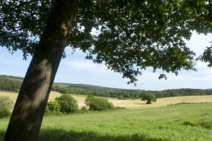
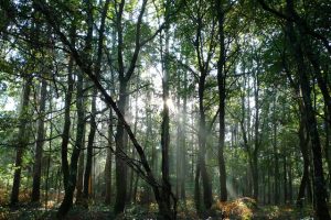
After leaving behind the houses of O Carballal (Km 1,5) we are surrounded by eucalyptus, species of deciduous leaves and meadows until the rough passage over the river Catasol, affluent of Furelos (Km 2,4). Postcard scenario that once again gives us the Camino. For a beautiful setting we head to Raido (Km 3.3), at the foot of the N-547. We leave your company quickly to continue to Parabispo (Km 3.9), and Concello de Arzúa (Km 18.7). Under a eucalyptus forest we saved the stream of Valverde, passed To Peroxa- where the Mojón 45.5 is located - and entered Boente, split in two by the N-547.
- Km 5.8. Boente (Hostels. Bars)
After the church of Santiago we turn right hand and go down a track to the Boente River and the place of Punta Brea, saving the N-547 by a tunnel. After surrounding a few meadows, we face a hard hill that rises to the foot of the N-547, and together with the national one, we reach several places of the parishes of Figueiroa and Castañeda, such as Fonte Plata and A Fraga Alta . In this area were the lime kilns where pilgrims deposited the stone they carried from Triacastela.
- Km 8. A Fraga Alta (Hostel. Bar)
We descend by paved runway to the Ribeiral Stream, located between Pedrido and Rio (Km 8.7). Now it is up to go back and go ahead, leaving to the left the detour to Doroña. Then, almost always by neighborhood slopes, we descend for two kilometers to the Iso River, which gives access to Ribadiso da Baixo, the parish of Rendal.
- Km 11.1. Ribadiso da Baixo (Hostels - Bar)
On the other side of the medieval bridge is the pilgrimage hospital of San Antón, currently restored as a public hostel. Right after that is the inn and the private hostel. We will find another later, in Ribadiso, just before reaching N-547 (Km 12,4). By the endless avenue of Lugo we arrived the first houses of Arzúa. In the same post there are several private hostels located one after the other. After another step we left the avenue to take the rustic Cima do Lugar, where the public hostel is located.
- Km 14.2. Arzúa (All services)
We start from the front towards the rustic cobblestone of Carmen. Its wooden roofs and facades make our way through Arzúa. In a rural setting we go down to the French fountain, cross the river Vello and then reach As Barrosas and his chapel of San Lázaro (Mojón 36 and Km 15). We went down to the river Brandeso, which in turn flows from the Iso (Km 16), and we went up to Curitiba, village of the parish of Burres with its chapel of San Paio of the 18th century.
- Km 16.3. Ask
At the exit we avoided the N-547 by a tunnel and faced a repeat, between meadows, maize crops and overlooking Arzúa, to the site of A Peroxa, also of the parish of Burres. Eucalyptus increasingly populates the Galician landscape and grasslands, necessary for the survival of livestock and the rural world. They follow each other with their familiar bedspreads drying in the sun. We travelled along canopy lined slopes and went down to the Ladron Rego (Km 18.1). Six hundred meters later, just before the 32.5 km to Santiago, there is the diversion to the hostel Camiño Ocas, which is 800 mt. We later reached Taberna Vella (Km 19.2). Then we enter Calzada, of the parish of Burres and the last inhabited nucleus of the Concello de Arzúa.
- Km 20. Road (Bar)
We left the population crossing a road and continued to enter the Concello de O Pino, the last one before Santiago. The first population is Calle, from the parish of San Breixo de Ferreiros.
- Km 21.8. Street (Bar. Bazaar)
We left the nucleus after crossing the Langüello stream and continued through a network of tracks and roads to Boavista (Km 23.2) and Salceda, at the foot of the N-547. On the left, on the other side of the N-547, 400 mt from the Camino, is the tourist hostel Salceda
.
- Km 24.8. Salceda (Hostels. Bars. 600 meters)
Already at the foot of the itinerary the bar La Casa Verde and the hostel of Boni. We demarcated a few meters from the national on the right, passing by the memory of the pilgrim Guillermo Watt, who died at this point. We returned to the foot of the road and crossed it by a concessionaire of agricultural machinery to reach O Xén, a place in the parish of San Miguel de Cerceda (Km 26,5). The road, to the left of the National, now leads to the immediate Ras of the same parish (Km 27,2). We saved the N-547 below. At this point, pilgrims from the Camino del Norte who have taken the O Pino variant can also link. On the other side is already A Brea
- Km 27.6. Mojón 23.5. A Brea (Cafe-Bar)
Immediately To Rabiña (Mojón 23 y Km 28). Parallel to the national we easily overcome the rise to O Empalme of the parish of San Lourenzo de Pastor. In the middle of the journey there is a meadow with a source and a windmill reminiscent of that of American farms. On the top we cross the road, with bar on both sides, to enter the population.
- Km 29.4. O Empalme (Bars)
Then we took a runway down under the eucalyptus. Below, through a tunnel under the N-547, we visited the chapel of Santa Irene and its baroque fountain.
- Km 30.2. Santa Irene (Hostels. Cafe Bar)
We pass by the private hostel, next to which lies the diversion to the rural hostel Astrar. After the hostel of the Xunta we enter a dense front of eucalyptus that momentarily isolates us from the road. We passed by the Mojón 20 and avoided the road again through a tunnel. A couple of houses and a sawmill drive to A Rúa of the parish of Arca.
- Km 32. A Rúa (Bars. Pensions. Rural Houses)
By paved track we reached the edge of the N-547 and climbed by it to O Pedrouzo.
- Km 33.3. O Pedrouzo (All Services)
The difficulties
Remarks
In images
What to see, what to do
The hostels

¿Do you want to send any photo of "The Camino de Santiago"?
If you have any photos of "El Camino de Santiago" that you want to share with us, you can send them to us and enlarge the photo gallery
Forum: What pilgrims think about the Camino de Santiago
See all