Article translated by an automatic translation system. Press here for further information.
Stage from O Pedrouzo to Santiago de Compostela
There is nothing left! You've traveled 755.3 kilometers and only 20 left
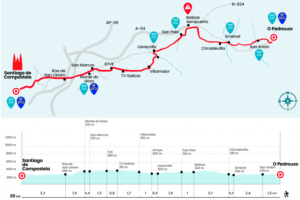
Information about the stage 13: Stage from O Pedrouzo to Santiago de Compostela

Enlarge map
The route
- Km 0. O Pedrouzo (All Services)
Twenty kilometres just in front of the 755.3 already travelled from our first day across the Pyrenees. Far, far away, even if only several weeks have passed, the Navarros forests, the Riojanas strains, the vast Castilian plateau remain. Even the mountains of León and the mythical O Cebreiro, which we ran seven days ago. Santiago, the Plaza del Obradoiro and the cathedral, to which we will be thrilled, surely, are here next door.
Taking as a reference the public hostel we walk the town by the national side and turn to the right by the rustic do Concello, where the Town Hall is located. We move forward for half a kilometer and when we arrive next to the school and the sports courts we turn 90 degrees to the left. On a dirt track covered by littering, we enter a forest of eucalyptus, which we leave to enter San Antón, village of the parish of Arca. The place takes the name of a chapel ravaged by a fire (Km 1.3).
Another forest awaits us at the exit of San Antón. Autochthonous carballos and reforested eucalyptus, in bulk, now accompany us to the center of Amenal, of the parish of San Miguel de Pereira. We access by paved runway and passing the river Brandelos cross the N-547 for a low pass (Km 3,7), followed by a strong echo that rises to Cimadevila, the last nucleus of the Concello de O Pino.
- Km 4. Cimadevilla
The climb continues for over a mile and a half but becomes much more affordable. At the top we head to the foot of A-54 and N-634. We no longer miss seeing the clearance fence filled with small crosses. It is part of the idiosyncrasy of pilgrimage. A monolith sculpted with the bourbon, the pumpkin and the vieira announces the entrance to the municipality of Santiago (Km 6,3). We surround the perimeter of the airport, leaving behind several rows of beacons (Km 6,7), and after crossing a secondary road we enter San Paio, village of the parish of Sabugueira.
- Km 7.7. San Paio (Bar)
We surround Casa Quian, we face a brief echo by paved runway and we take the runway on the right, which descends. After saving the variant below we continue to descend through several nuclei of the parish of Sabugueira: A Esquipa and Lavacolla.
- Km 9.5. Lavacolla (Bar. Store. Pharmacy)
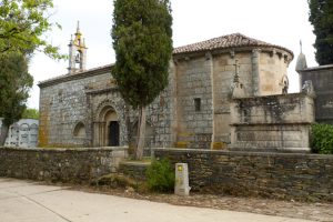
After a closed curve we pass by the parish of San Pelayo, which looks inscribed the year of its construction: 1840. Then we crossed the N-634a and took the detour to Villamaior. In just a hundred meters we crossed the river Sionlla, covered with ovas and known as the stream of Lavacolla, where the pilgrims took away their dirty clothes and washed in view of their next arrival in Santiago (Km 10).
By paved runway we start a comfortable climb that will end on the expected Monte do Gozo. We first traverse Villamaior (Km 11), pass by the center of the TVG (Km 12.7) and turn 90 degrees to the left to do the same together with the territorial center of RTVE (Km 13.5). We turn ninety degrees to the right and continue to the urbanization San Marcos, ahead of Monte do Gozo.
- Km 14.8. San Marcos (Bar. Store)
Instead of going forward, we turn left to climb the monument erected in the Jacobean year of 1993, the same year that the nearby pilgrim hostel was opened, the largest of the entire Camino that is able to accommodate up to 300 people a normal year and up to 800 a Xacobeo. From this point we get the first panorama of Santiago and its cathedral.
- Km 15.2. Monte do Gozo (Hostel. Bar. Store. ATM)
We retake the Camino, setting aside access to the cafeteria and dining rooms, and we go down to a stretch of stairs. Then we saved the highway and the roads by a bridge and made headway through the prolonged San Lázaro (Km 16,7), where there are the Palacio de Congresses and Exhibitions of Galicia and the pilgrim hostel San Lázaro, which allows you to sleep more than one night. We link to the rua do Valiño (Km 17,7) and continue forward by the rua das Fontiñas and rua dos Concheiros, where we cross the avenue of Lugo. Then the San Pedro rua (Km 19), which ends at the junction with traffic lights from the Aller Ulloa rua.
Through the place where the Porta do Camiño was, we entered the historic center by the rustic Casas Reais, which climbs to Cervantes’ field. The rustic da Acibechería takes us to the praza da Immaculada, where the monastery of San Martín Pinario is located. Finally we enter the Arch of the Palace by a passageway, where they meet to play street musicians, to access the Plaza del Obradoiro, where the adventure ends. As we take off the backpack, we discover every detail of the western facade and head to the center of the plaza itself. It's hard not to get excited. Reaching Santiago de Compostela as a pilgrim is an unparalleled experience and I believe that for many trips we have made around the world few are comparable to this one.
- Km 20. Santiago de Compostela (All Services)
The difficulties
Remarks
In images
What to see, what to do
The hostels

¿Do you want to send any photo of "The Camino de Santiago"?
If you have any photos of "El Camino de Santiago" that you want to share with us, you can send them to us and enlarge the photo gallery

Forum: What pilgrims think about the Camino de Santiago
See all