Article translated by an automatic translation system. Press here for further information.
Pontedeume to Betanzos stage
Typically Galician stage, with endless climbs and short falls
Information about the stage 3: Pontedeume to Betanzos stage
Enlarge map
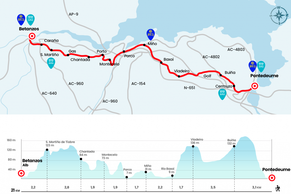
The route
- Km 0. Pontedeume(All services)
We return on our steps towards the bridge over the Eume River to access the historic center of this medieval village. From the Immaculate Conception we begin the ascent by the porticadarúa Real. On the left hand is the pazo of Don Bartolomé de Rajoy and Losada, archbishop of Santiago de Compostela in the eighteenth century and natural of Pontedeume. Above he departs from the Real farmhouse on the left towards the Plaza de las Angustias, where we link to the Calle del Empedrado, then Souto da Vila, which leaves us without oxygen anything else. The ramp compensates us with an excellent overview of Pontedeume, the Ría de Ares y Cabanas, with its Magdalena beach. We reached the height of the N-651 but we turned right into O Barro next to the number 60. We continue to gain altitude and, after two detours to right and left, we pass through the place of Cermuzo, of the parish of San Miguel de Breamo (Km 1,9) .
A rural reel, supposedly the old road, surrounded by fronda and overlooking the sawmill of Campolongo, fires the Concello de Pontedeume to access that of Miño. After the house of A Xesta we went to a Stop and went down to Buiña (Km 3.1). At the exit we cross the AC-4802 and between sinks and green area we draw the golf course of Martinsa-Fadesa, inaugurated in 2007 and designed next to the urbanization Costa Miño. Right after we entered the forest, a section prone to embark shortly after it rained, and we left it to bypass the AP-9 (Km 5.3). After following it in parallel, we turn left to face a demanding ramp under eucalyptus. The following places that visit the Camino Inglés are Viadeiro and Outeiro, from the parish of Santa Maria de Castro (Km 6.6) .
Paying close attention to the crossings that emerge in the villages, we ended up descending to the bridge over the Baxoi River, apparently also built in the 14th century at the request of Pérez de Andrade. As soon as we cross it, we are surprised by a beautiful riverside road between souths and ferns that passes by the houses of A Prata and under the viaduct of AP-9, which crosses the marshes of the Baxoi. The antithesis is the toll of the highway, which we surround to enter Miño. By the rúas da Fonte and Pardiñeira we reach the intersection with the rua de la Praia (AC-154), where the diversion to the pilgrims hostel of Miño, distant about 800 meters.
- Km 10.5. Miño(All services)
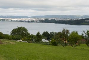
However, the Camino crosses the front to access the Real. We end up in the large A Barrosa country and say goodbye to the main core of Miño to cross the tracks, where we have a panorama of the Betanzos estuary and the mouth of the Lambre river, which we will cross later. After the bridge over the railway we turn to return to the course (conflictive point, nothing else to lower the railway bridge turn 180 degrees through the rustic alameda that in the descent passes by the beach) and glued to a wall we pass through the place of A Ponte do Porco. On the right is the beach of the Alameda, qualified as Place of Community Importance (LIC). Those who have not stopped at Miño can stop at the bar or at the inn.
- A Ponte do Porco / Playa de la Alameda(Bars)
- We continue through the rustic alameda until we pass under the N-651 and continue straight through the DP-4804 for this passing under the railway line and shortly below the highway, after a kilometer we reach the medieval bridge.
We cross the river Lambre by the Ponte do Porco, which divides the Concellos of Miño and Paderne. It was also raised by order of the good of Pérez de Andrade and the name of porch or wild boar refers to one of the emblems of its lineage. We will see the tomb of Andrade in the church of San Francisco de Betanzos, held by the figures of a wild boar and a bear (Km 12,2).
Behind the bridge, already in the Concello de Paderne, we turned left by a few houses. We get another brutal ramp of asphalt going up to Montecelo's playground. Ojo, next to the park we turn left hand and descend on a shaded track. A very nice section that, after a turn to the right, ascends to Montecelo, where we pass between the church of San Pantaleón das Viñas, which retains the Romanesque cover, and the pazo (Km 14,1) .
At 80 meters we reach the place of Trasmil and turn left to advance to the next Os Barreiros. Beware! Because at this point, the itinerary rotates 90º right, and it's very easy to wake up and follow in front of you. We descend to the place of Porto de Abaixo, opposite the café Navedo at the foot of the N-651.
- Km 15. Porto de Abaixo(Bar-Restaurant)
We walk 120 meters through the arcén and leave the N-651 on the left, thus facing a ramp that passes through A Penoubiña, first place in the parish of Santa María de Souto, and later through Chantada (Km 16) . We turn left side by side with a marquesina of the bus and continue on a herbose path, first, and asphalted runway, then, to the places of Vila de Meus y Gas, with a source of 1884.
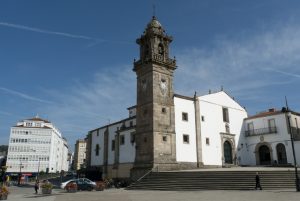
We enter the Concello de Betanzos, visiting through A Rúa and San Paio neighborhood slopes, overlooking the estuary and the mouth of the river Mandeo to reach the Romanesque church of San Martiño de Tiobre. This jewel, already mentioned in the ninth century, deserves a visit. It is located in the highest part of the Castro de Tiobre, where apparently the primitive nucleus of Betanzos was consecrated in the 12th century by the first Archbishop of Santiago, Don Diego Gelmírez. We found an excellent study and description of the temple in the Brigantino Yearbook by María del Pilar Carrillo (km 18.8).
Leaving behind the church and passing by the playground, we go down O Barral to the first junction, where we turn left. At the next crossing, turn right and continue the descent between vineyards until passing the Caraña regate. The path goes up the road leading to DP-0906. Crossing it, the route takes the road DP-0902 leading to the cemetery of Betanzos. We arrived at the Shrine of Nosa Mrs. do Camiño or the Remedies by the northern facade of the temple, which has its main facade facing the street of the same name. Continuing along this cobbled street, the path descends between examples of traditional architecture with wood corridors. Crossing the old bridge over the River Mandeo we enter Betanzos through the Porta da Ponte Vella, one of the five of the old wall. After her we turn left hand and climb up the Prateiros rude. Above, instead of entering the Plaza de los hermanos García Naveira, we turn right by the rua do Castro and after passing the City Hall we arrive at the hostel of pilgrims, located in the street of the Pescadería (Km 21) .
- Km 21. Betanzos(All services)
The difficulties
Remarks
In images
The hostels

¿Do you want to send any photo of "The Camino de Santiago"?
If you have any photos of "El Camino de Santiago" that you want to share with us, you can send them to us and enlarge the photo gallery
Forum: What pilgrims think about the Camino de Santiago
See all