Article translated by an automatic translation system. Press here for further information.
Neda to Pontedeume stage
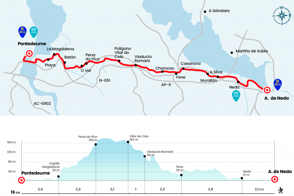
Simple stage, like the previous one, with only 140 meters of slope
Information about the stage 2: Neda to Pontedeume stage
Enlarge map
The route
- Km 0. Neda(All services)
Placid and beautiful walk we started next to the pilgrim hostel of Neda. An interpretive tour of wooden slabs and walkways that save the Marshes of the Belelle River, one of the few wetlands inhabiting the Ferrol estuary. After crossing a stream of the Belelle we turn 90º to the left to, after going to the road that divides the locality, visit the Baroque church of Santa Maria. It is 1721 and custody the Christ of the Chain, a Gothic Tudor style carving that came to Neda in 1550 aboard a British boat fleeing Anglican persecutions.
Crossing the catwalk over the Belelle River, which commemorates the passage through an old bridge, we access El Paraíso Street, which links to the Real Rua. With a clear medieval outline, it is flanked by porticated dwellings of the seventeenth and eighteenth centuries. The Clock Tower of 1786 awaits us at the top. Attached to it and to the Casa Consistorial are the remains of the Hospital de Peregrinos del Sancti Spiritus, founded in 1500 by Margarita Fernández do Vilar and her husband. On the other side of the staircase grows a tile planted by the Confraternity of Saint James (Km 2.1).
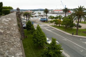
We descend through the same Real farmhouse and when we reach the Rectoral square we fold 90° to the left by the rustic General Morgado. If we continue a few meters ahead we can visit the church of St. Nicholas, which looks in the same atrium one of the oldest cruises in Galicia along with that of Melide. In both the obverse and the reverse, the figure of Christ is represented in a crude and disproportionate manner. The rustic General Morgado leads us to pass under the AP-9, after which we turn left to climb to the AC-115. We follow it on the right side of the Bar Gil to take shortly the road to Murallón, which begins next to the marquesina located in the left arche (Km 3,3).
Let us break into the skirt of the Marraxon, where we get the best views of the Ferrol estuary along with the concelles of Narón and Neda. From the top we descend to the right by the places of A Silva and O Puntal de Arriba. After the latter, instead of going down to the road, he turns left hand over the place of Conces. As soon as we pass a laundry room we visit A Fonte do Campo, the first place of the Concello de Fene on the English Way. The next arena will be A Casanova, after which we will cross the N-651 to pass by the Casa del Concello de Fene (Km 5,9).
- Km 5.9. Fene(All services)
Beware! Because a few meters later you have to take left Fraga street and then turn right onto Mayor Gerardo Díaz street. We are in the place of As Foxas, who passes the witness to those of Chamoso and Mundin, both of the Fenese parish of San Esteban de Perlío. Next to Mundin’s laundry we turn left and finally climb up a dirt road approached by a Helechal tupid and under the mixed deciduous and eucalyptus forest. It ascends to the N-651 but the Camino does not cross it, but it does pass under the Romariz viaduct of the AP-9 (Km 8.2) .
De Rego da Moa we follow the Immediate Romariz, places of the parish of Santiago de Barallobre. A narrow road between orchards and another more open road leads us to the polygon of Vilar do Colo, between the Concelles of Fene and Cabanas. At the entrance we can pause in the Service Area, which has a cafeteria and restaurant.
- Km 9.2. Poligono de Vilar do Colo(Bar-Restaurante)
- When you reach the roundabout where the restaurant Vilar do Colo is located, you have to turn left to then overcome another roundabout and go under the road N-651 to then go up some stairs to our right, from here carefully we walk a hundred meters to the arcén of the road to turn left and continue parallel to the road behind the houses, after half a kilometer we return to the road We continue along the arcén of the highway to the kilometric point 26 where we turn right on a downhill dirt road that soon becomes a local road that passes under the highway, after half kilometers of passing underneath the highway there is an information sign indicating an alternative path that 1.5 kilometers more than the official, we continue through the official until shortly after crossing the N-651, we come to the cross because it is very dangerous to cross
- Km 13.2. Cabanas. (all services)
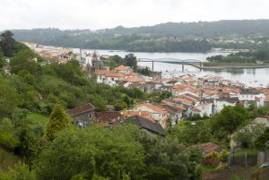
- Once in Cabanas we will only have to follow the arrows that take us down the road sidewalk to a roundabout that gives us access to cross the stone bridge over the Eume river and just cross into Pontedeume.
- Km 15. Pontedeume(All services)
The difficulties
Remarks
In images
The hostels

¿Do you want to send any photo of "The Camino de Santiago"?
If you have any photos of "El Camino de Santiago" that you want to share with us, you can send them to us and enlarge the photo gallery
Forum: What pilgrims think about the Camino de Santiago
See all