Article translated by an automatic translation system. Press here for further information.
Sarsamarcollar to Ena stage
The mountain has come to stay. They wait two hard days. Cheer!
Information about the stage 13: Sarsamarcollar to Ena stage
Enlarge map
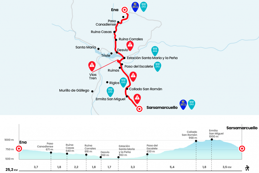
Points of interest in the stage 13: Sarsamarcollar to Ena stage
The route
You never want to wake up with a sudden ascent, more in a Road that is poorly accustomed to us because you rationalize the great efforts, which can be counted with the fingers of one hand. The mountainous part of the Catalan Way through San Juan de la Peña is here to stay and the itinerary will give us the best possible way to the Aragonese section of the French Way. The entire climb is concentrated in the first 3.5 kilometers. From the hostel, on the right, we go up the streets of Coso and the Middle, next to Casa Marina, and we continue down Herrería Street. Then on the right by Calle Mayor to the recreational area of the Fuente Alta, with a fountain rebuilt in 1856, a laundry room and a trough. The GR-95 says to follow the Item trace to Caesarea Augusta Beneharno, the Roman road linking Zaragoza with the French Béarn. The passage of this road here has been disassembled with reliable tests on the ground by the Public Works Engineer, Isaac Moreno Gallo, in his work Item a Caesarea Augusta Beneharno. The Roman Highway from Zaragoza to the Bearn.
A path between juniors, boj and skirmishes, with notable views of Sarsamarcollar and the landscape towards Ayerbe, soon reaches a runway, where the one that comes together comes from the western part of Sarsamarcollar, whose twists and turns we have saved ourselves from the laundry. It comes without loss, always overlooking the tower of Marcollar, until the chapel of San Miguel, at the end of the 12th century and that only conserves the apse and part of the nave (Km 3.5).
It deserves to be diverted 350 meters to approach the tower of the castle of Marcollar which, built under the command of Sancho El Mayor, was part of the line of fortifications created in the conquered border. The church of the Virgin of Marcollar, next door, was part of the defensive whole and is a restored Romanesque temple in the 17th century that hosts a crypt dedicated to San Esteban. After this point we return next to the chapel of San Miguel to continue the stage. We left the track that goes to the Mirador de los Buitres and continue to the hill of San Román, taking advantage of an unusual view of the Mallos de Riglos, famous conglomerate needles over the town of the same name (Km 5.3) .
We continue in the direction of La Peña and we can save ourselves a great curve that traces the track, descending down the way to the right, with the highest level during the first meters. Then we lose altitude on the runway, which is in perfect condition. On a curve we passed the diversion to the Foz de Garoneta (Km 6,8) and continued the march. The route is long, following the Forcallo ravine, and 3.3 kilometers later left the Pardina de Escalete. In this part of Aragon is known by pardines to agricultural or livestock houses. A few hundred meters below, the Camino crosses the foz of Escalete, one of the most representative natural milestones of this Jacobean itinerary, baked by the ravine of Forcallo (Km 10,7).
The passage over the bridge does not pose any difficulty, it is wide enough. The ravine opens its way to the river Gállego, an influent of the Ebro with more than 200 kilometres of travel from the border with France to Zaragoza. On the other side we see the Santa Maria Station and the Peña and the logging company Eiforsa. After the foz, the track remains on the left hand side. We followed it for more than a kilometer to the paved bridge over the Canfranero tracks, the safest step to cross them.
After the bridge we took the track to the right and later crossed the Gállego by a bridge parallel to the train. The waters of the river are regulated at this point by the reservoir of the Peña, built in 1913. Thus we arrive at Estación de Santa María y La Peña and the small nucleus of La Peña Estación, belonging to the municipality of Las Peñas de Riglos. Next to the road is the bar El Carmen, which opens every day from 11 am, where it will have to be supplied, because there is no place to buy in Ena. Also in La Peña Estación there is a bakery that opens from Tuesday to Saturday 10 to 2 with a mini store with commodities.(see observations) (Km 14)
We follow the A-1205 road to the left for almost two kilometres. Please note that before crossing the bridge over the Sad ravine, yellow arrows and the red and white marks of GR-95 on the margas encourage you to leave the road and
drift through the badlands (Km 15,8). After overcoming the first level we continue along a beautiful path over the ravine. We opened a portillo (after we always have to close it) we follow the path, which passes along several ruined pens where the cattle kept some neighbors of Sad (Km 17,6).
A kilometer later, we crossed a firewall and walked out in a few minutes to a runway, which we followed on the right. We went next to an abandoned house owned by the Hydrographic Confederation (Km 19,8). The idea of placing steps to vadear the Ena ravine, which is the one flowing from now on to the right, is good. But not the shape, with some horrendous cement blocks, and it's easy to find some flooded ford. In a bifurcation that goes on, we continue in front, always at the edge of the river. We passed a Canadian step (Km 21,5) and still crossed the stream again. In short, already with the presence of cereal fields that denote the closeness of Ena, we reach the detour that leads, on the left, to the Chapel of the Virgen del Camino and later also to Ena. The toponym of the hermitage leaves no doubt, as reflected by María de los Ángeles Magallón in his work Red Viaria Romana in Aragon, with conclusions contrary to Isaac Moreno. This Little Tour trail has been marked since 2013 with the Jacobean brands and is the one we recommend.
If desired you can also continue to Ena by the track, in front. Upon arrival the whole, even of the Hoya, is thrilled, but sharing its features and physiognomy with neighboring Jacetania, such as the roofs of slices and their trchoconic fireplaces, already Pyrenean. A few meters from the church of San Pedro and next to Casa Bergosal is the hostel of pilgrims (Km 25.2).
The difficulties
Remarks
In images
What to see, what to do
The hostels

¿Do you want to send any photo of "The Camino de Santiago"?
If you have any photos of "El Camino de Santiago" that you want to share with us, you can send them to us and enlarge the photo gallery


Forum: What pilgrims think about the Camino de Santiago
See all