Article translated by an automatic translation system. Press here for further information.
Bolea to Sarsamarneck Stage
Beware of the slopes between Aniés and Loarre by the mismatch
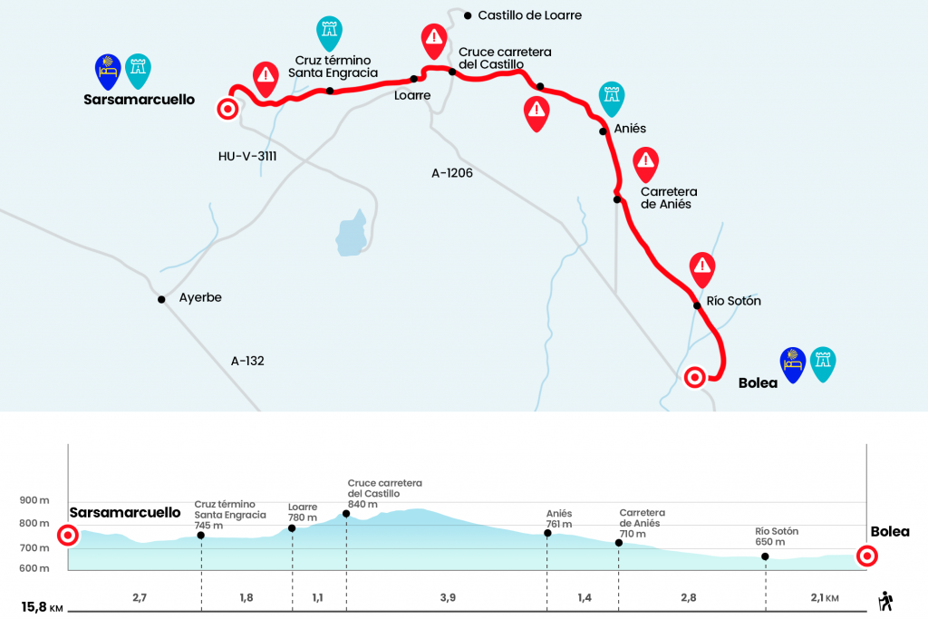
Information about the stage 12: Bolea to Sarsamarneck Stage
Enlarge map
Points of interest in the stage 12: Bolea to Sarsamarneck Stage
The route
We return the steps towards Calle Mayor, climbing the streets of the Carretera y del Medio and rotating next to the City Hall of Bolea, which groups the whole municipality of La Sotonera. Calle Castilla is the first on the left. We follow it to a stop and continue on the left. A plate indicates GR-1 Aniés - San Cristobal, we pass the channel of the San Andrés ravine and continue on the left the Jacobean and GR-1 indications (Km 1,5). We left to the right the junction that goes to the chapel of Santa Quiteria, and from the front we passed the Soton River Slide, which gives name to the municipality (Km 2.1).
The first part to Aniés is a comfortable walk between fruit trees and Mediterranean crops that accompany the pilgrim's sunny days. On the right is the barrier of the Pyrenean Outer Saws of Gratal, Caballera and Loarre, whose castle can already be distinguished, albeit mildly, between the roquedo. Since 2012 there are also new signs of the Camino Natural de la Hoya de Huesca that share paths with the Camino de Santiago in this section. Just before leaving the Aniés road there is a parallel road between the boj and the carrascal that avoids half a kilometer of asphalt (Km 4,9).
Then we go to the road before the curve on the Fermelar ravine and before entering Aniés, we leave the asphalt on the left and cover the final meters on a road, where the octagonal tower of the church of San Esteban stands out among the fruit trees. Next to this 18th century parish, which retains the Romanesque cover (behind the gate), there is a park and a table.(km 6.3)
From the other side of the church from which we have come down a cement trail to the Riel River and we take the road to the Castle of Loarre, which marks 5.1 kilometers, although we will not touch the medieval fortress. The old paths that climbed between the shrubland have become a ugly and anodine stony, which looks like a hot highway. The steep slope sections, especially one, are more bearable if we lift the head of the soil stones and look at others: those of the Romanesque castle. A prodigious stronghold, a national monument and designed by Sancho El Mayor in 1020 to keep the line conquered and move forward positions. Fifty years later, an abbey was built that housed a community of St. Augustine canonigos that brought activity to this place. The construction and importance of the castle of Montearagón, which we saw before yesterday from the Saso, begins the decline of Loarre and much of the population that lived next to the lower castle to more gentle lands and founded the town of Loarre, half way from Aniés to Loarre we will find a bifurcation marked with a pole that indicates that we turn right on the climb to go.
We go down to the small one arch bridge over the Aston River and turn left to enter Loarre. We continue by the stream and turn right onto Siphon Street and then left onto Solanilla Street (Km 11,3). Here is the interesting cover of Casa Pola. We went to the plaza with bars and the interesting Chisclay bakery with good sweets. Before leaving Loarre remember to buy for dinner and breakfast or for the next stage! (see observations). From the Baroque church, we go off the road to the right. The road signs and the GR-1 signal, Santa Engracia – Sarsamarcollar, invites us to leave the road on the right in oblique to the exit of the population. We follow the gravel trail, which saves the ravines of Calderillas and Alago, for a kilometer and a half, and we end up on the road, next to the end cross of Santa Engracia, belonging to Loarre (Km 13,1).
One hundred and fifty meters later we left the road to take another track for 700 meters. Then we leave it on the left to take a path between carrascas and boj that goes to the bed of the stream Palangás, where we must pay attention to the yellow arrows and signs of the GR that are on the stones. It leads us to cross it, and then we go up in a strong slope to save a hill. It reaches a runway and at the fork we follow in front (the one on the left enters Sarsamarneck by the road). With the last breath we enter Sarsamarucollar on a rocky road. Already in the village, a legend indicates Camino. We mortals descend to the hostel, which is at the bottom, in Plaza Mayor.(km 15.8)
The difficulties
Remarks
In images
What to see, what to do
The hostels

¿Do you want to send any photo of "The Camino de Santiago"?
If you have any photos of "El Camino de Santiago" that you want to share with us, you can send them to us and enlarge the photo gallery
Forum: What pilgrims think about the Camino de Santiago
See all