Article translated by an automatic translation system. Press here for further information.
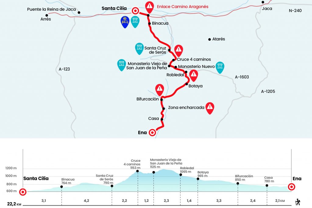
Stage from Ena to Santa Cilia
Short and intense climb to the New Monastery of San Juan de la Peña
Information about the stage 14: Stage from Ena to Santa Cilia
Enlarge map
Points of interest in the stage 14: Stage from Ena to Santa Cilia
The route
We leave the hostel on the right, in the opposite direction to the plaza, and back to the right to exit the rural access road. In a hundred meters we left it on the left to take a road, coinciding with the GR-95 of the Roman itinerary that we follow from Sarsamarneck. At a short distance, in the first bifurcation, we continue on the right, always close to the Ena ravine. Later we went next to a house, which is the house of a couple (Km 2.1).
The journey continues in the North direction, gaining height gradually, between boj, heather and dressings. The section is very prone to wrap up, due to the proximity of the Barranco de Ena and several torrents, and we will have to avoid puddles and even skip or polish some channels that come down from the left side. Four kilometers away from Ena we will see a less clear road out on the right hand, also marked with yellow arrows. It's a variant that attaches a runway section, in case someone is interested. If we go past the detour, we will continue through the GR-95, and at 600 meters our way turns right, throwing away another one that continues on the left.
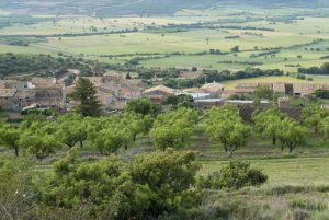
So far, the route opens to the valley where Botaya is located, covered with cereal and sparceta, a foraging legume of pink flower that is cultivated for cattle and also in order to stop desertification. We can see the population of Sodoruel under the protected mountain of San Juan de la Peña. In Botaya, the first of the region of Jacetania on the Camino, there is a social bar, on the left entrance, and a private hostel (see observations). Past the bar is the church of San Esteban, which retains from the Romanesque church the baptismal pile, several windows and the eardrum of the south facade. It shows a pantocrator surrounded by Tetramorfos, with three animal figures and an angel representing the four evangelists, and also a crismon flanked by the Apostles (Km 7,8).
He leaves Botaya on Calle Mayor to take the road, where there is a fountain. We continue through it about 800 meters and abandon it on a stony path that is born to the left hand, where apart from the arrows we still find the indications of the GR-95. We climb along the Botaya ravine to penetrate into a cozy stand (Km 9.2), which will test our resistance with a short and intense climb. After a final stretch of more complicated stone we regain our breath to portray the beautiful mixed-forest stamp that doves beneath our feet (Km 9,7).
The San Indalecio prairie is comfortably reached between the thresholds of wild cubes, oak and pines, where the New Monastery of San Juan de la Peña is sun-coated. It hosts several Interpretation Centers, a luxurious Hospedería, a souvenir shop and a bar-restaurant. His works began in the wake of the fire that ravaged the Old Monastery and extended from 1676 until the beginning of the 19th century (km 10.5).
We take the road towards the Old Monastery, but instead of going down through it we do it on the signalized path that unites both cenobians. It's born right away by the left hand. It is a stony and veiled path of roots in strong descent. It has a final stretch of stairs that go out onto the road. We follow it on the left down to the real Monastery of San Juan de la Peña, icon next to Montserrat and that gives name to this Camino. The ecuador of the stage invites to sign up for one of the guided tours. You don't have to miss these opportunities, walking is the medium, not the end. He was probably born as a monastery in San Juan Bautista in the 10th century and was refounded a century later by Sancho el Mayor. A shelter from the impressive rock of conglomerate reposes the cloister, its most attractive jewel, accessed by a Mozarab gate. In many of the capitals, decorated with the Jaqués taqueado that was born and spread on the Camino de Santiago, the expressive figures of large eyes made by the Master of San Juan de la Peña (Km 11.5) stand out.
Next to the information and sales booth, we take the GR-65 3.2 towards Santa Cruz de la Serós. It reaches a hill where four roads are separated (Km 12,7). We took the one from Santa Cruz, on the left. The route descends on a rocky path, amazed by the precipice, overlooking the Berdun Canal and the Pyrenean Mountain Range. A section with enviable views that gives way to an arboreal tunnel and a stream of thick songs. We will leave to a more peeled area to cover the last part, already with views of this population of the Jacetania of about 200 inhabitants. The path goes to a gravel trail and instead of crossing the river we turn right. It is the fastest way to reach the church of Santa Maria, which belonged to a female cenobium at the end of the 10th century, from which comes the name of Sorores that has arrived as Serós (Km 14,9).
In Santa Cruz de la Serós there are bars, restaurants and shops and we have to replenish forces for the lonely and rough journey from over an hour to Binacua. The route continues towards the church of San Caprasio, which looks like a mockup. Antonio García Omedes, in his complete web work on the Aragonese Romanesque, presents this church as “the Lombard building situated more west of all Aragon”. From the 11th century, it was restored by 1950 and stripped of additions from later centuries.
We leave Santa Cruz de la Serós by the road and then, next to a fountain, go up a runway to the left. The first meters are the most pending, then it smoothes and the runway flows in a winding path, which subsequently reaches a hill. It doesn't come down from sopeton, and by a pinar, let's go down the slope. Then a downhill path to the ravine of Fuente Biescas (Km 18). We accompanied its margin and already by track for a long period we entered the hamlet of Binacua (Km 19.1).
At the exit is the parish church dedicated to the Saints Angels. It is also Romanesque, from the 12th century, with the blind arquilles typical of the Lombard style on the apse and a nice cover. The Catalan Road of San Juan de la Peña is a step away from linking to the French Road that enters Spain by Somport (perhaps misnamed by all of us Aragonese Road). We go down the road and before we reach the N-240 we come together with the major road and the pilgrims who come from Jaca. A moment of great celebration in antiquity, when connected to the main stream, for the security it provided (km 20,4). We arrived at the N-240 for a goose and crossed it with great care to enter Santa Cilia de Jaca. The pilgrim's hostel is located in the historical complex, in Calle del Sol, 8 (Km 22.2).
The difficulties
Remarks
In images
What to see, what to do
The hostels

¿Do you want to send any photo of "The Camino de Santiago"?
If you have any photos of "El Camino de Santiago" that you want to share with us, you can send them to us and enlarge the photo gallery
Forum: What pilgrims think about the Camino de Santiago
See all