Article translated by an automatic translation system. Press here for further information.
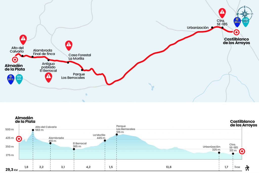
Stage of Castblanco de los Arroyos to Almadén de la Plata
Heavy first section by road to Parque los Berrocales
Information about the stage 3: Stage of Castblanco de los Arroyos to Almadén de la Plata
Enlarge map
Points of interest in the stage 3: Stage of Castblanco de los Arroyos to Almadén de la Plata
The route
- Km 0. Castilblanco de los Arroyos (All services)
We started the day descending along Antonio Machado Avenue, next to the road. At the exit of the town you have to take the SE-5405. If we depart from the town centre, the yellow arrows will guide us to the church of the Divine Savior to walk down the road. Ahead more than 15 kilometers of asphalt (Km 1).
In a kilometer and a half, on our right, we will leave the urbanizations Las Minas and Sierra Norte (Km 2.7) that have a residential area that exceeds that of Castilblanco. We will go up the hill surrounded by cork oak and oak trees of cattle and lidia. In fact, we will go next to the dehesa "Yerbabuena", owned by Ortega Cano. At the highest point of the road, 520 metres high, is an antenna of the STAR (Telecommunications for Regional Development) programme. One kilometer later, finally, we left the road next to the entrance of the Parque Natural los Berrocales (Km
16,5).To note: After 1.6 km. from the entrance of the dehesa Yerbabuena, on the road SE5405, just before the km. 10 a runway has been enabled on the right side of the road that leads directly to the entrance of the Sierra Norte Natural Park, avoiding several km. I'm walking around the arcèn. To reach this safe and pleasant path whose beginning is not indicated, it must be accessed from the right arcèn.
During the tour of the estate it is very likely to see more than one deer. Encouraged by this possibility, we enter through the door that is in the fence and continue our path. In a kilometer and a half we pass by the forest house La Morilla and continue for an hour on a runway that winds through the park. Taking into account the signs, we have to turn left onto a dirt track, where we cross over a small stream and we see a modern miliary, like the one we saw yesterday, and the ruins of the old village El Berrocal (Km 22.2) .
We follow the trail, flanked by some repopulated pines, to the fence that delimits the estate (Km 25,3). After it, the road becomes narrower and, between jars, we are gaining altitude and also fatigue, until the Cerro del Calvario (Km 27,5) is finished. From the top there is a good panorama: to the north Almadén de la Plata, its mines and the Cerro de los Covachas; to the south an unenlarged Mediterranean mountain spot. We go down for a kilometer and we get to Almadén. The hostel is located across the town.
- Km 29.3. Almadén de la Plata (All services)
The difficulties
Remarks
In images
What to see, what to do
The hostels

¿Do you want to send any photo of "The Camino de Santiago"?
If you have any photos of "El Camino de Santiago" that you want to share with us, you can send them to us and enlarge the photo gallery

Forum: What pilgrims think about the Camino de Santiago
See all