Article translated by an automatic translation system. Press here for further information.
Almadén de la Plata to Monesterio
Last day for the Andalusian serrany that gives way to Extremadura
Information about the stage 4: Almadén de la Plata to Monesterio
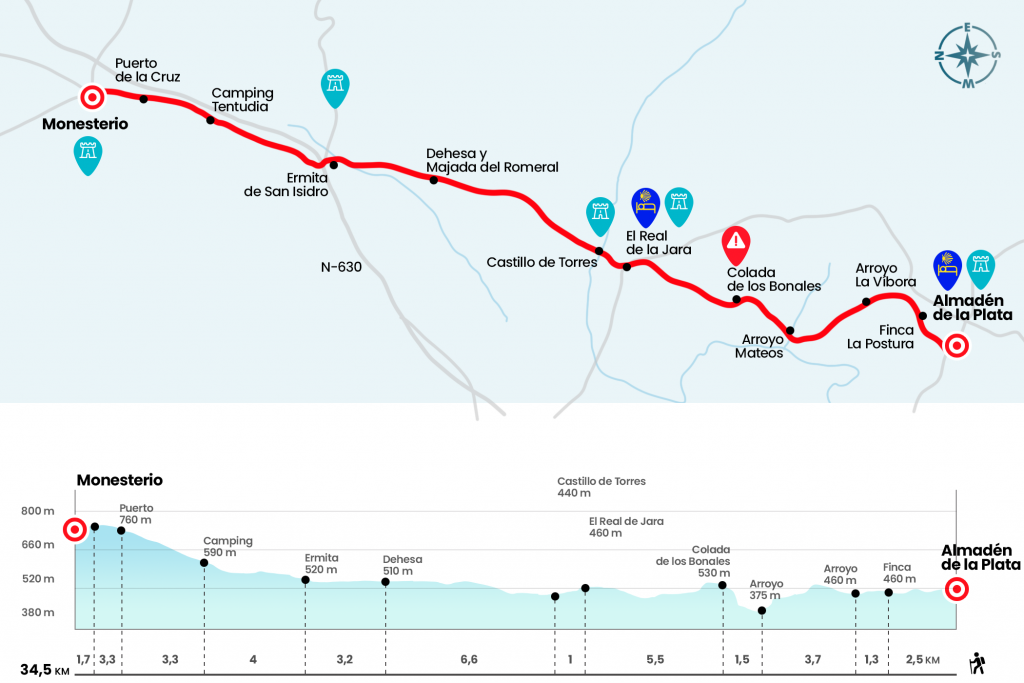
Enlarge map
Points of interest in the stage 4: Almadén de la Plata to Monesterio
The route
- Km 0. Almadén de la Plata(All services)
Following the trail of yellow arrows through the streets of Almadén we climbed to the bullring. The hill of the Covachas rises on the front. We abandon the population between solar panels installations and later, already declining through an area with some booties, we are looking for the first cancel of the stage. They are countless during the first stage. Next to a piara of Iberian people we reach a formidable porticated house named La Posture (Km 2.5), past the house we reach a bridge and attention, nothing more crossing it to a hundred meters you have to turn left, although it is well signalized it is easy not to see the disvidence.
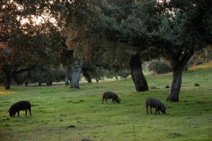
The road will lead us later to cross the stream of the Vibora (Km 3.8), a few hundred meters from the road leading to El Real de la Jara. We're still on a slight climb by the channel. After the first hour of stage the profile becomes smoother and the next two and a half kilometers will be a tour of the Arroyo Mateos estate, where we will be able to enjoy an admirable environment and the company of a whole variety of domestic animals. A strong descent will lead us to cross the Mateos stream, the lowest point of the stage that in the maps is reflected with the name of the stream of the Huerta del Corcho and that spills its waters to the Rivera del Cala (Km 7.5). A few 250 meters is the limit with the province of Huelva but we did not get through it. Now the road rises and, in a few hundred meters, we arrived next to a sign that informs us about the route of the Colada del Camino Viejo de Almadén or Los Bonales (Km 9).
We will continue the climb through this route and parallel to a line of high
tension. A more technical descent leads us to pass another cancel and leave the private grounds. Four kilometers on a large runway, virtually plain except in the final stretch and in the vicinity of the Robles dehesa, take us to El Real de la Jara, the last Andalusian town on the route. The town is accessed by Pablo Picasso Street next to the municipal hostel. The few fifteen kilometers that we take, although with the route of ‘breaking legs’, will raise some the continuity of the stage to Monesterio, distant another twenty kilometers.
- Km 14.7. El Real de la Jara(All services)
The one who decides to follow, with the view in the medieval castle that dominates the village, leaves El Real de la Jara by San Bartolomé Street to take the cordel of Monesterio. In only one kilometer, after passing the limit of the province of Seville and entering Badajoz, we cross the stream of the Vibora (Km 15,7). On the right are the ruins of the castle of the Towers, of uncertain origin and function. It is believed that he was raised in the Lower Middle Ages and his original structure still retains three circular base towers.
Without shadow we can go through the large cordel next to the Vistahermosa estate. Later, after four and a half kilometers of El Real de la Jara, we will cross our path the path of the Smugglers Route that descends from the Sierra de San Roque, located several kilometers to the right. With no more notable references we reached the junction with the EX-103 road, next to the futurist hermitage of San Isidro (Km 25.5). We are still on the left hand and two hundred meters away there is the N-630, whose trail we lost in the first stage in the town of Santiponce. We continue through it, on the right and direction Monesterio. We pass under the highway and we take a path that moves along the right of the national. Three and a half kilometers of continuous ascent and with the N-630 on our right, we are located in the upper part of the port of la Cruz (Km 32.8) . After a merchant we enter Monesterio, a town of services divided by the national road.
- Km 34,5. Monesterio(All services)
The difficulties
Remarks
In images
What to see, what to do
The hostels

¿Do you want to send any photo of "The Camino de Santiago"?
If you have any photos of "El Camino de Santiago" that you want to share with us, you can send them to us and enlarge the photo gallery
Forum: What pilgrims think about the Camino de Santiago
See all