Article translated by an automatic translation system. Press here for further information.
Merida to Alcuéscar stage
Remember that from Aljucén to Alcuéscar there are 20 kilometers without populations
Information about the stage 9: Merida to Alcuéscar stage
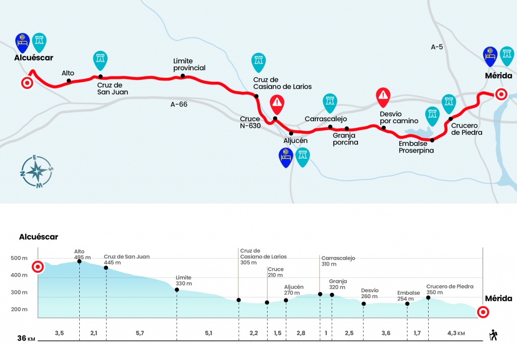
Enlarge map
Points of interest in the stage 9: Merida to Alcuéscar stage
The route
- Km 0. Merida(All services)
On the Roman bridge that saves the stream Albarregas, small brother of the great bridge over the Guadiana, the pilgrimage continues and begins as such the Vía de la Plata: the Roman road that linked Mérida with Astorga and whose path will offer us great days for the lands of Extremadura and Castilla. However, we will still have to wait a few kilometres to support our feet on history. The current option is to let us be guided by our inseparable yellow arrows and head towards the Proserpine reservoir.
From the bridge over the Albarregas we continue in front of Avenida Vía de la Plata and brands soon force us, after a roundabout, to continue along Avenida del Lago. This route is the natural exit to the dam road. Half a kilometer later, on the right hand, we take this road (with pedestrian rail), which passes over the A-5 motorway and continues on comfortable ascent to a stone cruise (Km 4.3). After a section of descent to the glorieta de Proserpina we pass the urbanization, the paddle courts and the campsite before reaching the Roman dam (Km 6).
Behind it we take a path to the right that avoids the asphalt and borders the lake, a river and leisure environment for many Emeritans who come to spend the day as a family and for the fishermen, who tempt the tents with their rods to the American tents, grills and perches. In short we go back to the road and continue through it for more than two and a half kilometers until arrows, on the left of the road and painted on the trunk of a oak (Km 9,6), save us from the asphalt and guide us on a slightly blurred path to a wider path delimited by two hunting farms. After a Canadian walk, a porcine farm (Km 12,1) and some cancellations enter the street Camino de Santiago in El Carrascalejo.
- Km 13.1. El Carrascalejo
Of this small population stands out the Church of Consolation, of the 14th and 15th centuries and also known as Santa María del Camino, which we border to leave the town.
After an area of vineyards we reach a tunnel under the highway that is decorated with Santiaguista drawings. We cross it and when we reach the high, where a Cross of Santiago rises, we see the following population:Aljucén.
- Km 15.9. Aljucén(Hostel. Bars. Ultramarine. Pharmacy. Termas)
We left Aljucén on the avenue of Extremadura and walked through BA-011 until its union with National 630. In a hundred meters we pass over the river Aljucén, affluent of the Guadiana, and before reaching a gas station we left the road on the right to catch a track (Km 17.4). In this way we will travel for 6 kilometers part of the Natural Park of Cornalvo and Sierra Bermeja, a large space due to the Mediterranean forest inhabited, among others, by birds as rare as the black stork and the blue elanium. We advance along the runway – with the reference of the river Aljucén, which flows to the right – until reaching another metal cross of Santiago, work of the blacksmith Casiano Larios (Km 19,6).
A few meters later the yellow color of an H1, one of the many granite cubes placed by the Junta de Extremadura to signal the Vía de la Plata, tells us that we are on the right track. The runway narrows and slowly moves away from the river. Encinas, alcornoques, some other Canadian step and a cancela lead us to the provincial boundary between Badajoz and Cáceres that coincides with a poster for the end of the journey through the Natural Park (Km 24,7). A granite H3, with photographs and texts from the Aljucén – Alcuéscar (Crossing of the Smiths) section, gives way to a short rising stretch with a lot of stone. After a lockdown, we move on to a runway that runs through a more deforested terrain, repopulated with cork ponds, where more than one herd of merins and more than one passionate quad. After the 30th kilometer of this long stage we met the cross of San Juan (Km 30.4).
Comfortably, looking at some houses on our left, we reached a high to follow the indication of the right leading to Alcuéscar (Km 32.5). At 600 meters from the village, next to a cement trail that goes up to Alcuéscar, the arrows guide the left road, which attaches and leads directly to the entrance road to the population.
- Km 36. Alcuéscar(All services)
The difficulties
Remarks
In images
What to see, what to do
The hostels

¿Do you want to send any photo of "The Camino de Santiago"?
If you have any photos of "El Camino de Santiago" that you want to share with us, you can send them to us and enlarge the photo gallery

Forum: What pilgrims think about the Camino de Santiago
See all