Article translated by an automatic translation system. Press here for further information.
Stage from Markina Xemein to Gernika Lumo
"Broken legs" stage where you enjoy the beauty of the Urdaibai
Information about the stage 5: Stage from Markina Xemein to Gernika Lumo
Enlarge map
The route
- Km 0. Markina (All services)
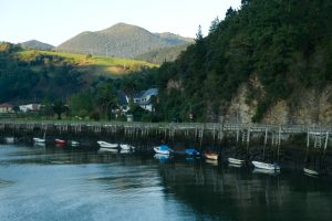
Next to the hostel is the cafeteria Kai, where we turn until we cross the river Artibai, which next to the river Lea, which we will visit during the stage, give name to this Biscay region. We continue to be linked to a park to finally get out to the arcén of the BI-633, which we follow until the chapel of Our Lady of Erdotza, probably the 16th. In this place we fired off the road on the right and traversed one of the neighborhoods of Markina. We take a bidegorri, the red bike lane, hence its name in Euskera, which advances between a polygon and the river. Here's a source. Then we cross the river by a walkway next to the Kareaga Bridge, a single arch and semi-hidden by the hihedrias. After the river we turn left hand, passing a cancela, and we enter into a nice riverside path, with some stones and roots embedded, that reaches near Iruzubieta.
- Km 3.8. Iruzubieta (Bars)
In this population there are a couple of bars, although they are probably closed in the first hour. With a slight rodeo, we left by the road BI-2224 and took a road by the restaurant Armola. Go up to the Altzaga district. Next to the access to a hamlet we turn right and between pines and portillos we arrive soon to the neighborhood of Arta, corresponding already to the municipality of Ziortza Bolibar. We dropped to BI-2224 and entered Bolibar, from which came the family of the Venezuelan liberator Simon Bolivar. We went by the museum dedicated to its figure and we reached the plaza, where the town hall is located and a helpful bar on its stands.
- Km 6.2. Bolibar (Bar. Store. Baketxe Baserria accommodation at 1.9 km)
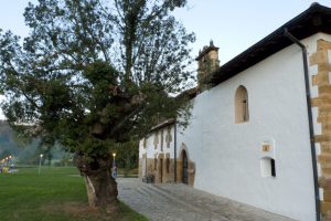
Together with the Church of St. Thomas, with a strong defensive face with its two towers attached, we left for a moment on the road to enter a street and follow the route of crucis and the medieval road that ascends to the Cistercian monastery of Zenarruza. The Ziortza Beitia Hostel, reopened in June 2014, is a few meters from this cenobium. We enter Zenarruza under an arc (next to the window above the eagle's shield with the skull, the legend of which is explained in the information panel) and cross the garden. The old schoolgirl is Gothic and you can also visit the cloister.
- Km 7.5. Monastery of Zenarruza (Hostel)
A path watered by several streams leads to the high of Gontzagarigana (Km 9). The main road remains on the right and we continue on the left, descending by paved runway to the district of Uriona (Km 9.8). We resumed the descent to Munitibar and the Lea River basin by a hillside and later by a dark path between the shrubland, complicated by the slope and with risk of falls, which ends next to a beautiful rural house. A hint brings us closer to Gerrikaitz, the neoclassical church of Santa Maria, restored in 1847, is left, and after crossing the river Lea we enter Munitibar. Almost on the equator of the day, the plaza is another good place to take a break, with hostel, bar and store.
- Km 11.7. Munitibar (Hostel. Bar. Store)
The parish of San Vicente de Arbaztegi, which was able to take the place of a hermitage dedicated to San Miguel, and again the river Lea point out the annoying echo of the district of Aldaka. Up here, 50 meters from the Camino, there is a chapel of Santiago in the 18th century. Then the track continues to the right and as soon as you pass the high-voltage line, without going to the BI-2224, we take the neighborhood track on the left and go down next to the Urnatei farmhouse. At this point we take a path that goes under thousands of volts and over an angled area that feeds on several streams. Later on, moreover, if you haven't cleaned it up, there's a section where we're going to pull weed apart to make way. The tour ends next to the Berriondo district of the municipality of Mendata. Like many others, its founding origin was an anteiglesia, in this case that of San Miguel Arcángel in the 10th century, which is but a community of dispersed neighbors that gathered in assembly around the parish church.
- Km 16.2. Berriondo (I turned to the Mendata hostel a little later. Restaurant nearby)
A neighborhood runway reaches the BI-3224, which we follow to the Zarra district (Olabe). On the left hand is the diversion to the hostel Idazte Etxea de Mendata! At this crossing of roads, ours moves right to the Zarrabenta restaurant. Be careful because we do not follow the road that is recommended for bikes. We traversed the neighborhood, visiting the chapel of San Pedro and San Cristobal, rebuilt in the late 18th century and rehabilitated in 1878. We leave the nucleus, where the diversion to the tower of Montalbán, on the pentagonal floor, is located, and we take the path that goes down and crosses the robledal vetusto shared between the municipalities of Mendata and Arratzu, one of the intact jewels of the Urdaibai Reserve. Later, a well-recovered section of the road passes over the medieval bridge of Artzubi, which serves as the border between the two municipalities. After crossing the Gola River we entered the Elexalde district. Here we can see the church of St. Thomas, which dominates the landscape of Arratzu. This temple, where the medieval road passed, stands out for its choir.
- Km 19.1. Elexalde
Following the Via Crucis we descend to the Gola River, with an old ferreria already in disuse since the 19th, and we begin the strong climbing to the Marmiz district (Km 20,3) . At the same entrance, instead of taking the BI-3224, we fold right next to a house and resume the climb, much more contained. We will leave the population behind to continue along a path that runs along the Burgogana skirt, between insigne pine and eucalyptus, two rapidly growing species that were introduced into the peninsula to the detriment of native forests. This nice route falls to the municipality of Ajangiz , specifically to its neighborhood of Mendieta. He has been independent from Gernika since 1991. The impressive neoclassical church of the Ascension is a work of John the Baptist of Belaunzaran who finished his son in 1860.
- Km 23. Ajangiz
From Ajangiz there is no more to continue along the road, tackling one of the curves, and letting us take to Gernika. At the entrance, next to the stop of St. Bartholomew Street, we turn right and take Kortezubi bidea, the first to come to our left. The youth hostel is 100 meters away.
- Km 25. Gernika (All services) In 2017, from 1 to 31 August, opens the municipal hostel managed by the Association of Hospital Volunteers of the Camino de Santiago for Bizkaia!
The difficulties
Remarks
In images
What to see, what to do
The hostels

¿Do you want to send any photo of "The Camino de Santiago"?
If you have any photos of "El Camino de Santiago" that you want to share with us, you can send them to us and enlarge the photo gallery
Forum: What pilgrims think about the Camino de Santiago
See all