Article translated by an automatic translation system. Press here for further information.
Güemes to Santander stage
Beautiful pilgrimage to Santander and to the beach of Sardinero
Information about the stage 13: Güemes to Santander stage

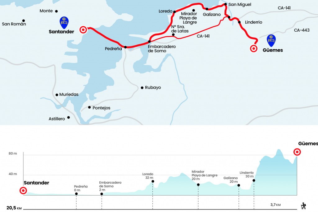
Enlarge map
The route
- Km 0. Güemes (Hostel)
From Abuelo Peuto's hut descends a road to the local road CA-444, which crosses the Gargollo neighborhood and flows into the CA-443, which we follow to the left. Always by the arcén arcén, between soft hills, we will reach without loss to the Linderrio district, where the Posada El Solar (Km 3,3) is located.
- Km 3.3. Barrio Linderrio (Posada)
Just afterwards we met the CA-141, which we followed on the left to enter Galizano, population of the municipality of Ribamontán al Mar. As soon as we enter, next to a branch, we turn right to the CA-440 leading to Langre and Loredo. After the office we arrived next to the church of Nuestra Señora de la Asunción, where we must decide which route to follow to Santander.
- Km 4.4. Galizano (Hotel. Bars. Shops. ATM)
The official route returns from the church to the CA-141 and travels through it for forty minutes to enter Loredo and visit the Shrine of Santa María de Latas. During the festivities in her honor, the gothic carving of the Virgin is transported by foot and boat to Santander. Then the Camino de Santiago advances to the pier of Somo to take the Pedreñera to the capital.
We recommend, however, the coastal variant, excellent option with good time. Another path taken in the hostel of Güemes, which is perfectly connected with the dream of a path arrived at the sea, although it was by no means the pilgrims who preceded us. This variant is on the right of the church, towards the beach next to the hotel la Vijanera. It goes all the way towards the coastline entering the San Miguel neighborhood, where we will see the first signs. We take a little rodeo, arriving at a house called Aguasonda, and after crossing a stream we pass by another house to surround the wall of a property. The road, marked by the rolling rolls and the agricultural machinery, runs between the planting and the vertical cliff of the small beach of Arnillas and the extensive Langre. On the latter, half way, there is a viewpoint with several banks (Km 7.4) .
On the left, Cabo Galizano enters the sea and our path continues to religiously draw the silhouette of the cliff, circulating on the edge of the precipice. It is important to know, or at least intuit, when we have to leave the path and move towards Loredo. We have to do it after a red-white antenna, where the houses end. We walk away from the cliff and reach an urbanized street (Km 10.7).
If we follow the street in front of us and then turn right, in the end we will have no choice but to continue left, towards the beach. Continuing through sand is the funniest option. A road between dunes brings us closer to the beach of Los Tranquilos, and then we soak in the Loredo Arenal, with the views of the Cantabrian capital and the Magdalena Peninsula, with its palace. We can borrow Somo on this beach and go inland looking for the pier.
- Km 14.7. Somo (All services)
The 'Pedreñera', as they call it, works all year round and the ticket to Santander costs around 2.65 euros. In the middle of the journey, it collects passengers in Pedreña (Km 16,6). Finally, when landing on the Santanderino promenade of the Pereda, the least confusing option to reach the hostel is to continue to the left on this walk and the street of Calvo Sotelo. At 400 meters, just before we reach the City Hall, we take the street that rises to the left, is the Rúa Mayor. In number 9, well signposted, is the pilgrim hostel.
- Km 20.5. Santander (All services)
The difficulties
Remarks
In images
What to see, what to do
The hostels

¿Do you want to send any photo of "The Camino de Santiago"?
If you have any photos of "El Camino de Santiago" that you want to share with us, you can send them to us and enlarge the photo gallery


Forum: What pilgrims think about the Camino de Santiago
See all