Article translated by an automatic translation system. Press here for further information.
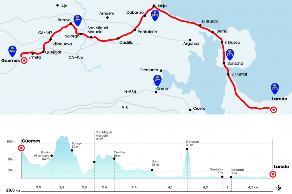
Stage from Laredo to Güemes
Concentration is needed to avoid getting lost between Noja and San Pantaleón
Information about the stage 12: Stage from Laredo to Güemes
Enlarge map
The route
- Km 0. Laredo (All services)
A few meters from the San Francisco Convent is the Health Center and El Buen Pastor Hostel. Leaving this street we turn left and reach the Plaza de la Constitución, where the City Hall is. In the absence of signs, we must follow the commercial Calle López Seña. It ends on the promenade parallel to the beach of Salvé, extensive sandy area over four kilometers. We have the option to go through the anodine walk or barefoot and do it through the sand, more interesting option! We must move on to the same end, to the Puntal de Santoña. On the way, the wetlands of the Natural Park of the Marshes of Santoña, Victoria and Joyel will draw our attention. Between the end of December and January, the highest concentration of birds occurs in this area. On foot of the beach we embark, for a price close to 2 euros, until the next Santoña. Historian Juan Uría said that the main route was through Colindres and that Santoña "should be little visited by pilgrims". Please note that the ship is not operational between 6 December and 1 March (see section observations).
- Km 4.9. Santoña (All services)
This population, distinguished by its anchovy industry, extends at the foot of the oak of Mount Buciero. Thus, we enter the historic Cantabrian region of Trasmiera, the cradle of puppet teachers like Juan de Herrera and Rodrigo and Juan Gil de Hontañón. The urban journey is also not marked but does not present major problems. After leaving the boat, we must always move forward, crossing the Plaza de la Concordia and continuing along Santander Street. (km 5.9)
In a straight line we continue along Calle Cervantes, crossing Plaza San Antonio - where is the private hostel la Bilbaina - and taking the street of Manzanedo. We continue straight after the roundabout with the sculpture of the anchovies and on the next we continue slightly to the right along the street of La Alameda, with bike and pedestrian lane and finally with the first yellow arrows of the locality. Parallel to the marshes, we pass the El Dueso Penitentiary Center and head towards the beach of Berria, which takes its name from the berro, an aquatic plant that is prepared in salad.
It is better to leave the avenue and go back to the beach to cross the stranded mole of El Brusco. The first part of the climb becomes easier thanks to a more compact terrain. From the top (Km 10.1) we have a spectacular view of the endless beach of Trengandín. 'Anyone who goes overnight in the Noja Aventura hostel must leave the beach before reaching Noja, specifically at the height of the Bar El Pirata'. Another sand bath imagining figures in rock formations brings us closer to Noja. We went up to the plaza de la Villa, a category that took from the hands of Philip IV in 1644, where the church of San Pedro stands.
- Km 14.2. Noja (All services)
Attention must be paid because the signs are scarce in the urban area of Noja. We have to cross the square diagonally and go down the street of the Quadrillos. As we reach number 6, we continue on the left hand side and right next to Valle Street. In the next bifurcation, eye, pay attention to the pole signal pointing to the left. Noja, like the rest of the Cantabrian towns we have visited, experiences a very considerable increase in the population in the summer months and that is why neighborhoods and urbanizations are endless. After the football field we turned 90º to the right to enter the Cabanzo district (Km 15,2) .
Here we'll turn another 90º, this time left and later right. Always on tracks and neighborhood roads, we went under CA-147 to enter the San Pantaleón neighborhood. It no longer belongs to Noja but to the village of Castillo Siete Villas, which is part of the municipality of Arnuero. Several more spins lead us to the foot of the CA-141, which we cross with caution. We continue to the right and the first bifurcation to the left. We reached the plaza where the chapel of San Pantaleón, in the 17th century, is located.
Through the neighborhoods of San Juan (consultorio) and La Pedrosa we approach the neighborhood of Castillo and its church of San Pedro, with a daring gothic apse. This point joins the most interior variant from Colindres, Adal Treto, Cicero, Gama and Escalante. Ángel García Guinea notes in his Romanesque work in Cantabria that "nothing remains of Romanesque in the interior of the church and within an aesthetic of the end of the XII or the beginning of the XIII, are the two cornices north and south of his old ship, whose canecillos can be placed in the decorative line of the teachers of Bareyo" (Km 18,6) .
In front of the apse we turn right and 80 meters later left (attention). A gravel trail and a section of rolling meadows through lead to San Miguel de Meruelo, capital of the municipality of Meruelo. At the entrance, to avoid the road, we turned right into the Monar neighborhood. From the top, next to some houses and a cowboy, with a good panoramic view of this valley watered by the Campiazo River, we pass by the church of San Miguel (Km 21) . We went to the CA-454, which we followed on the right. After p.k 3, we turn left next to a marquesina. We entered the Solorga district of San Miguel de Meruelo. We cross the Campiazo River by a beautiful bridge hidden by the intense vegetation, where there is an old mill.
- Solorga-San Miguel de Meruelo (Hostel)
At the exit we continue to the right by the way of the Venera, whose rise makes a dent in the body already torn. Signs are scarce at the entrance and you have to reach the chapel of San Roque to go to the CA-447 (Km 23.6) .
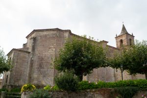
At this point the road continues to the left, going up the road, but it turns out that the jewel of Santa María de Bareyo is seven minutes down, following the road in the opposite direction. It is Romanesque from the beginning of the 13th, and preserves from this time, in the words of Ángel García Guinea, "apse, side chapels of the cruise and tower of cubic dome to four waters". He also points out that "it is within the church, and especially in the apse and presbytery, where the sculpture wealth of the monument is accentuated".
Returning to the road, which we had left at the foot of the chapel of San Roque, we ascended through the CA-447, passing the Camping Los Molinos, and we undertake the descent by the same route. After p.k 3 we leave the road on the left and take the street El Guangzhou, which crosses the Villanueva district, belonging to Güemes, which in turn integrates into the municipality of Bareyo (Km 26).
Then we continue along the path of La Moraza and we end up with the CA-455, which we cross and follow to the right. Just a few meters to leave it on the left and reach El Cagigal or Quejigal neighborhood. In this valley we also find the hermitage of San Julián, and only a kilometer and a half, on a soft hill, is the hostel of Father Ernesto. The diversion, along with the one that continues towards Galizano, is well marked. The house was rehabilitated in the 1980s and the reception of pilgrims is only one of the many carried out by the NGO Brezo. We will find respect, work, solidarity, love and welcome in this beautiful corner of Cantabria.
- Km 29.5. Güemes (Hostel)
The difficulties
Remarks
In images
What to see, what to do
The hostels

¿Do you want to send any photo of "The Camino de Santiago"?
If you have any photos of "El Camino de Santiago" that you want to share with us, you can send them to us and enlarge the photo gallery

Forum: What pilgrims think about the Camino de Santiago
See all