Article translated by an automatic translation system. Press here for further information.
Sangüesa to Monreal
We take strength and say goodbye to the river Aragon to the valley of Ibargoiti
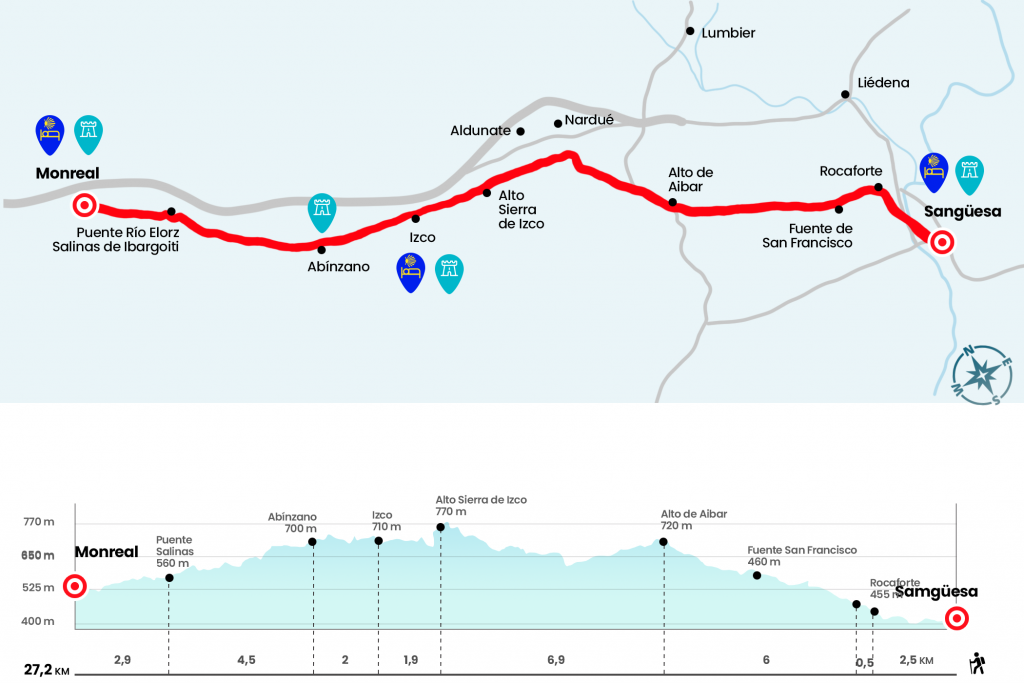
Information about the stage 5 by Somport: Sangüesa to Monreal
Enlarge map
Points of interest in the stage 5 by Somport: Sangüesa to Monreal
The route
- Important Warning: The hostel in Izco will stay CLOSED during 2017.
- Km 0. Sangüesa (All Services)
Advancing in a straight line through the streets Enrique de Labrit and Alfonso the Batallador turn left hand to take Calle Mayor. After passing the cover of Santa María la Real we have the last encounter with the Aragon, a river that we crossed through a bridge at the end of the 19th century that ended the structure of the 11th century Romanesque bridge. At the exit we continue on the right and we walk a few six hundred meters down the road. Just until the diversion to Rocaforte (see observations in case of choosing the Lumbier Foz variant). We take the detour to quickly take a path that is born next to the right wing and that faces the hill where Rocaforte is built.
- Km 2.5. Rocaforte
At the entrance of the village, a Jacobean plate points out the options towards Rocaforte and towards Alto de Aibar. We choose the latter and continue on the right to take a runway that passes next to the San Francisco fountain, where a recreation area with merendero and several barbecues has also been enabled (Km 3). The track opens a path through an open ground, sown with cereal fields, vines and scattered olives and under the wind park of the Sierra de Salajones. Without strong repeches, but constantly ascending, progress is made for six kilometers to the top of Aibar, which we crowned after a tunnel (Km 9).
A path drawn on the road and overlooking the village of Lumbier leads us to quickly down the hillside of the mountain. Continue to lead us in a small pine forest, to which we open a portillo to enter a trail. Later, pass a Canadian step in the area of the Basobar ravine, the runway curves and look!, because it must be abandoned by a wooden portillo on the left (Km 12).
On another forest track, with the close reference of a line of wind turbines on the ridge of the sierra, we are surpassing the slope. One kilometer after a livestock vessel we reach
770 meters of altitude at a high of the Sierra de Izco, the highest level of the stage (Km 15,9).
Through a small coniferous forest we go down to an agricultural track leading to Izco, entering the Ibargoiti valley. At the gates of Izco we receive a modern cruise and an informative panel of the valley and its populations. The signs lead to the plaza, where the fronton and pilgrim's hostel are located (Km 17,8).
- Km 17.8. Izco (Lodge-Bar-Shop)
At the exit of the village we continue along another plot, straight and with several undulations, that reaches Abínzano, the second inhabited nucleus of the valley.
- Km 19.8. Abínzano
After Abínzano, more of the same. It moves along the runway for another hour to the outskirts of Salinas de Ibargoiti. Without entering this population, we crossed a bridge over the Elorz River.
- Km 24.3. Salinas de Ibargoiti
Let's turn left to briefly continue next to the river. For a comforting and final tranche under a tupid bouquet of boj bushes we present ourselves in Monreal. We cross the medieval bridge over the Elorz and progress in front of Santa Barbara Street to turn left and climb the stairs that end next to the hostel door.
- Km 27.2. Monreal (Hostel. Bar. Store. Pharmacy. ATM)
The difficulties
Remarks
In images
What to see, what to do
The hostels

¿Do you want to send any photo of "The Camino de Santiago"?
If you have any photos of "El Camino de Santiago" that you want to share with us, you can send them to us and enlarge the photo gallery

Forum: What pilgrims think about the Camino de Santiago
See all