Article translated by an automatic translation system. Press here for further information.
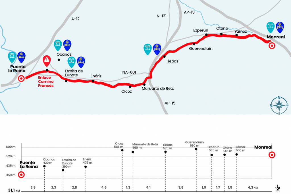
Stage from Monreal to Puente la Reina
Demanding stage in which the Aragonese Road and French merge
Information about the stage 6 by Somport: Stage from Monreal to Puente la Reina
Enlarge map
Points of interest in the stage 6 by Somport: Stage from Monreal to Puente la Reina
The route
Caution: THERE IS NO ALBEGUE of pilgrims by the chapel of Santa Maria de Eunate.
- Km 0. Monreal (Hostel. Bar. Store. Pharmacy. ATM)
From the hostel in Monreal, we go out in front of the alley and, after the church, turn left onto the street of Burg to leave the population. Once in the open field we go straight forward. The A-21 motorway is on our right and the cereal fields, the forest gallery of the Elorz River and the Higa, tearing us from its 1288 meters, to our left. The road is looking for the fertile bank of the river and, after accompanying its course for a kilometer, crosses it and moves to the left by a runway (Km 2.2). Soon, the trail becomes a path that grabs the slopes of the Alaiz Mountains. The path leads by Yárnoz.
- Km 4.3. Yárnoz
The last mile is an advance of what follows. The path is attached as it can to the changing orography of the saw. Also, as soon as it opens to the valley as it penetrates into the Mediterranean forest. From this spirit we went to Otano.
- Km 5.8. Otano
Half an hour later we arrived at the village of Ezperun (Km 7.5), where the only visible thing is the operation of a quarry and the canal of Navarra, a hydraulic infrastructure that distributes the regulated water of the Itoiz reservoir through the province. In a strong repecho, we follow a paved runway that passes under the quarry and descend down a nice guarded road that leads us to the entrance of Guerendiin.
- Km 9.4. Guerendiin
Leaving this locality, of monumental houses engulfed with geranies and decorated with multiple Jacobean references, we say goodbye to the valley of Elorz. A long stretch 'breaks legs' and technical leads us to Tiebas and his 13th-century castle.
- Km 13.2. Tiebas (Hostels. Bar. Bakery)
We cross the village, leaving aside the church of Santa Eufemia. After the football field we take a road that runs parallel to the fence delimiting the AP-15 motorway. When we reach a roundabout, we cross a tunnel under the freeway and then pass the N-121 highway. Later, through another small tunnel, this time under the train tracks, we arrived at Muruarte de Reta.
- Km 17.3. Muruarte de Reta
Watch out for signs, because before you reach the first houses you have to turn left onto the paved runway. Following this local road we arrived at Olcoz and thus to the region of Valdizarbe. As an interest, a neighbor of Olcoz offers guided tours to the lineage tower, rehabilitated in 2012. It's four floors and dates back to the 14th and 15th centuries. Inside is the permanent exhibition 'Eunate-Olcoz: Keys to the Camino de Santiago. The Navarre treasure of the first Renaissance of the 12th century'.
- Km 18.6. Olcoz (Bar)
At the entrance of the population we continue on the right to, shortly, take a path that descends by a hill and from which you get good views of the region and the canal of Navarra. For a small section of asphalt and a posterior track we are presented in Enériz, good site also to please a dry throat and an empty stomach.
- Km 23.2. Enériz (Bar. Store. Pharmacy)
It continues along the runway until a cairn forces us to turn right between the bushes. A good stratagem to revive the suspense, as after the gallery the silhouette of Santa Maria de Eunate is discovered. Romanesque hermitage, with an octagonal plan and surrounded by a archery, whose originality has earned him good fame on the Camino de Santiago. The hostel annexed to the hermitage left its hospital function in autumn 2012 and since 2013 the house hosts activities of the parish group of Muruzábal (Km 26).
One kilometer from Eunate we crossed the road to Obanos. In the Plaza de los Fueros of this town, next to the church of San Juan Bautista, our itinerary merges with that of the pilgrims who left, mostly, San Jean Pied de Port or Roncesvalles.
- Km 28.3. Obanos (Hostel. Bar. Store. Pharmacy. ATM)
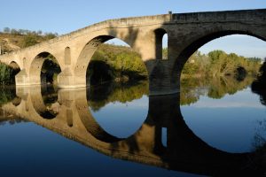
After a row of pilgrims much larger than usual, we left Obanos and went down to the road, which we crossed to take a path parallel to the river Robo. Shortly we arrived to the arcén of the N-111 and to the entrance of Puente la Reina. In the centre of the town, 31.1 km of this harsh stage are covered.
- Km 31.1. Puente la Reina (All Services)
The difficulties
Remarks
In images
What to see, what to do
The hostels

¿Do you want to send any photo of "The Camino de Santiago"?
If you have any photos of "El Camino de Santiago" that you want to share with us, you can send them to us and enlarge the photo gallery
Forum: What pilgrims think about the Camino de Santiago
See all