Article translated by an automatic translation system. Press here for further information.
Phase from Jaca to Arrés
Prepare to overcome the section of the goats
Information about the stage 2 by Somport: Phase from Jaca to Arrés
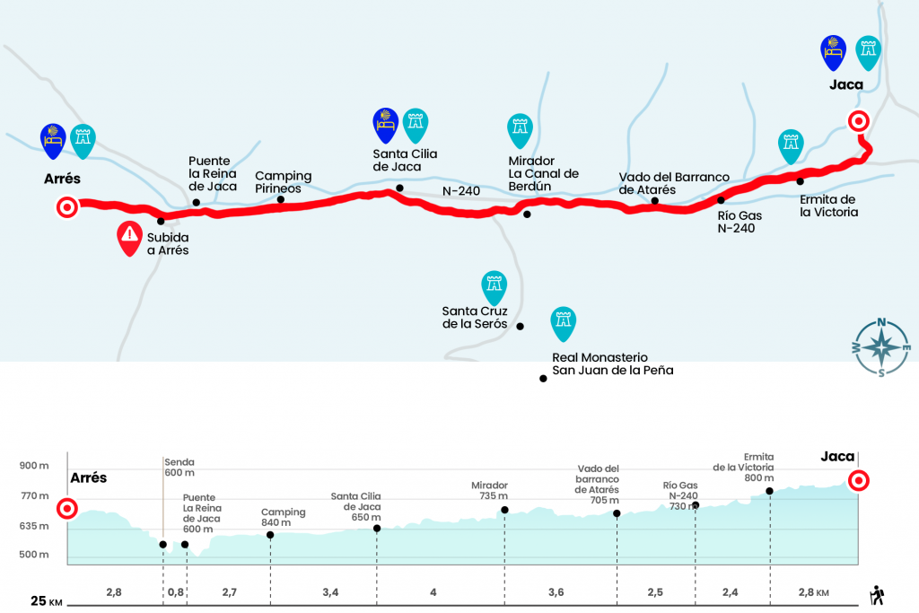
Enlarge map
Points of interest in the stage 2 by Somport: Phase from Jaca to Arrés
The route
- Km 0. Jaca (All Services)
Thanks to the bronze shells strategically placed on the pavement, we managed to advance along the road network of downtown Jaca. The tour allows you to see the gothic Clock tower and the church of Santiago. Next to it we can turn right by Calle del Coso and then left by Bajada de Baños. We reached the roundabout where the gas station is to take the N-240 towards Pamplona. In short, next to the military headquarters, we left the national one on our left and continued through an urbanization and a small polygon just outside Jaca. We arrived at the foot of the Victoria hermitage, a symbol of victory over the Muslims to which the Jaqueses come in pilgrimage on the first Friday of May (Km 2,8).
At this point we cross the N-240 and take in a short time a goose (canned of cattle) that emerges next to the right wing and that passes over the riverside forest of the Aragon River. After twenty minutes he departs again to the national at the height of the Botiguera to cross the river Gas (Km 5.2) and reach by the caseta del Municionero. A wooden pole of GR 65.3.2 indicates the diversion to Atarés and San Juan de la Peña (see section observations), but we continue in the direction of Santa Cilia by GR 65.3. Then, before kilometric point 288 of the N-240, the road is crossed and left on the right. He then re-crosses to take a path that reaches the Ataris Canyon, which we saved through a walkway conditioned in the Holy Year of 2010 (Km 7,7).
Once you get over, you go off to the road that goes up to Atarés and, listen, take it right. It leads us to a path that we started by plains to derive in a section with a more marked profile that reaches the viewpoint of the Berdun Canal, a small atalaya on this vast orographic depression covered with cereal and surmounted by the river Aragón and the grey strip of the N-240 (Km 11,3).
We descend abruptly and pass behind the Aragon hotel and the historic sale of Esculabolsas , old inn of walkers and merchants. After saving a water regate we walk a few meters field through and cross the road A-1603 that goes up to Santa Cruz de la Serós and San Juan de la Peña. Then we continued straight through a cabanera that leads us to Santa Cilia, a town we entered after crossing the road. The urban route leads us to the same historical center.
- Km 15.3. Santa Cilia (Hostel. Bar. Bakery. Pharmacy)
We left Santa Cilia for a cabanera and some rounds stuck to the national after which we managed to subtract two and a half kilometers more from the total of the stage. Reaching the kilometric point 300, we crossed the N-240 and left the campsite Pyrenees on the right hand (Km 18,7). Glued to the left wing we travel two kilometers, up to kilometric point 302, and we cross the national one to enter through a grim path that goes down to the river margin, where hundreds of pilgrims have taken advantage of the roaded songs to form with them vertical structures similar to chimneys. All of them form an amazing landscape. In three hundred meters we reach the stone bridge over the Aragon de Puente la Reina de Jaca.
- Km 21.4. Puente la Reina de Jaca (Bars. Shops. Pharmacy)
Without crossing, we left this locality of services on the right hand and continued straight on a local road towards Arrés, leaving to the left the A-132 road heading to Huesca. Later, a wooden pole marked with the indication 'PR-HU 23. Arrés 3 Km' invites us to take a path that ascends the skirt of Mount Samitier. The first kilometer exceeds a strong gap but it is passing the hardness until finally reaching 700 meters of altitude in Arrés, end of stage.
- Km 25. Arrés (Hostel. Bar)
The difficulties
Remarks
In images
What to see, what to do
The hostels

¿Do you want to send any photo of "The Camino de Santiago"?
If you have any photos of "El Camino de Santiago" that you want to share with us, you can send them to us and enlarge the photo gallery
Forum: What pilgrims think about the Camino de Santiago
See all