Article translated by an automatic translation system. Press here for further information.
Stage from Somport to Jaca
161 kilometers to delight in the military fortification of the nineteenth century
Information about the stage 1 By Somport: Stage from Somport to Jaca
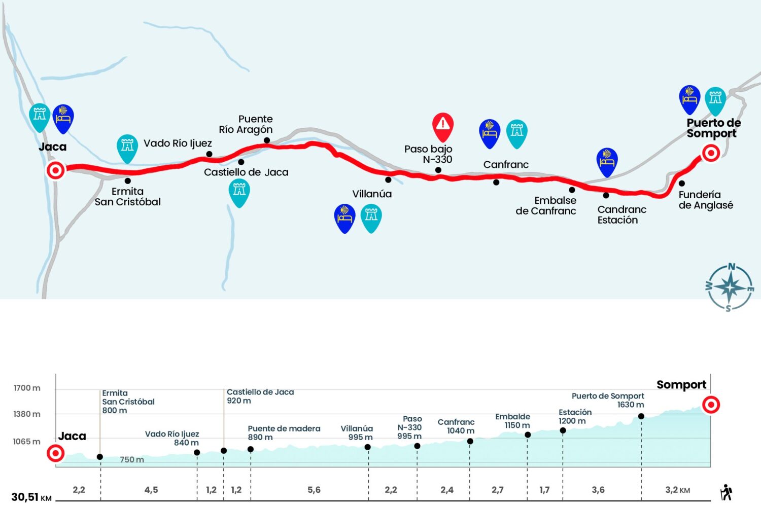
Enlarge map
Points of interest in the stage 1 By Somport: Stage from Somport to Jaca
The route
- Km 0. Somport (Hostel. Bar)
A wooden sign with the indication "GR 65.3 Canfranc Estación" and a Jacobean mojón carved with the distances to Santiago de Compostela (858 Km) and Undúes de Lerda, last Aragonese population (87 Km), incite to take the first step. We go down the stairs that are next to the mojón to continue descending next to the right margin of the Aragón River. Just 800 meters away we surround the excavated floor of the hospital of Santa Cristina, a renowned pilgrim hospital founded in the Late Middle Ages. After leaving the winter season of Candanchú on the right hand side, we crossed the N-330, we saved the small slope thanks to some stairs and we restarted the downhill valley march. The presence of some concrete bunkers and the challenging panorama on our right, with several Pyrenean moles rising over the Rioseta camp, make the journey easier until we come across the chimney of the Funderia del Anglasé, a saddle tower that represents the only vestige of an old copper and iron mine.
After a brief encounter with the forest we went out to a track and turned left to save the riverbed coming from the Roya Channel. Then we opened a wooden portillo and took the path again. A kilometer later, a wooden bridge allows you to cross the waters of the Iza ravine, which also plummets towards the Aragon River. We continue down a narrow path eaten by the lush vegetation and behind the Coll de Ladrones, two strong defensives of 1758 and 1900 mimicked on the rock. The aroma of a bread oven opens the appetite reaching the corner of the N-330, a road that we follow to enter Canfranc Estación.
- Km 6.8. Canfranc Station (All Services)
A paved sidewalk allows you to leave the town by the river, although after the last houses you return to the side of the road to cross a tunnel. At the exit it is turned to the left to take some stairs that go down to the foot of the Canfranc Dam (Km 8.5). Crossing the Aragon River we enter a path that zigzags on the cut formed by the erosive action of the river. From this viewpoint you can see the Fusileros Tower, a 19th century military fortification located on the edge of the N-330. In some sections the road becomes gloomy thanks to the beech cover and descends to the Ip ravine, where a cold waterfall greets (Km 10). We crossed the bridge, even with the freshness of the ferns and the forest, to travel the kilometer that separates us from Canfranc.
- Km 11.2. Canfranc (Hostel. Bar)
The town is crossed by Albareda Street, which divides the town into two equal halves. We left on the left the parish church of the Assumption to cross the Aragon River along the medieval bridge. Kneeling between the mountain and the river we continue for more than two kilometers until we reach an underground passage that crosses the N-330 and that forces us almost to crouch (Km 13.6).
Another stretch of two kilometers, with the perspective of the river under our feet, leads us to pass next to the cave of the Güixas, a cave of stalactites and stalagmites. Immediately you reach the entrance of Villanúa, where the first alternative of the stage arises. The first option, the GR-65.3 turns to the right, crosses the bridge over the Aragon and continues to Castiello de Jaca by a cabañera (barge for cattle) parallel to the N-330 and subsequently by a plain over the valley. The second option, signposted as GR-65.3.1 takes us first to the center of Villanúa. We will now describe the two options:
- Km 15.8. Villanúa (Hostel. - Bar. Bar. Store. Store. Pharmacy. Pharmacy. Cashier)
GR-65.3: Next to the Villanúa fountain we turn to the right. After leaving the village behind we crossed the river, finding the yellow arrows to our left. We advance along the road along the road for approximately 2 kilometers to the Leisure Park Aventura Villanúa (kiosk with soft drinks and coffee during the summer and spring weekends). We took the road again and when we reached the archery zone we crossed the N-330. We leave the school-building to the right and ascend gently about 700 meters to reach a plain. Through it we continue our journey through the valley of the Aragon. Two kilometres later we came across the county that joins the N-330 with Aratorés. We follow the road on the left for 200 meters, taking the road back to the right side of the road. After crossing a small stream through a wooden bridge we went up a few meters to another plain over the valley, the old glacier moraine that takes us in a couple of kilometers to Castiello de Jaca.
GR-65.3.1:Next to the Villanúa supermarket we turn left and leave Villanúa after leaving behind the church of San Esteban.. We rely on the red and white marks of the GR, which guide us for more than an hour, first by paved track and then by dirt tracks, up to a bridge over the Aragon (Km 21,4). We passed it to reach the N-330, which we crossed with attention to climb to Castiello de Jaca.
- Km 22.6. Castiello de Jaca (Hostel. - Bars. Bars. Store from April-May 2015)
Leaving the church of San Miguel on the right, it descends down the street to the national road. We crossed it to reach the service area of the town and then we returned to save the Aragon River by another bridge. A rewarding walk along the margin of the river leads us to cross over a catwalk enabled in 2010 on another channel, this time that of the Ijuez River (Km 23,8). Once this point was solved, which was previously conflictive and thanks to the walkway has remained in the memory, we resumed the march half an hour more until crossing the road. Then we continue more than two kilometers glued to the side of the N-330 and by some parallel cabañeras. We arrive thus to the hermitage of San Cristobal (Km 28,3).
After the bridge we face the strong crest of the Health Slope to enter Jaca. From the front, along the Avenue de Francia, we reach the Cathedral Square and continue through Bellido and Puerta Nueva streets to turn right along the Hospital street and again to the right by Conde Aznar, where the hostel is located. End of stage.
- Km 30.5. Jaca (All Services)
The difficulties
Remarks
In images
The hostels

¿Do you want to send any photo of "The Camino de Santiago"?
If you have any photos of "El Camino de Santiago" that you want to share with us, you can send them to us and enlarge the photo gallery
Forum: What pilgrims think about the Camino de Santiago
See all