Article translated by an automatic translation system. Press here for further information.
Blade Stage from Rei to Arzúa
It is the longest stage in Galicia, also known as "broken legs"
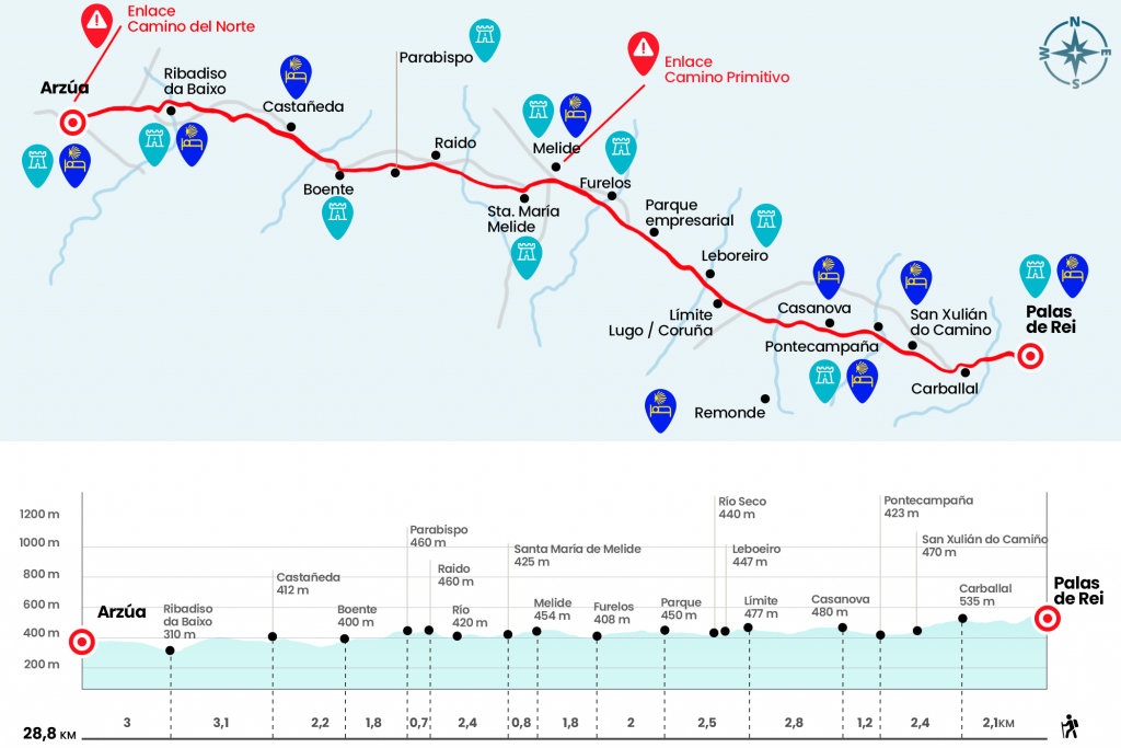
Information about the stage 29: Blade Stage from Rei to Arzúa
Enlarge map
Points of interest in the stage 29: Blade Stage from Rei to Arzúa
The route
- Km 0. Palas de Rei (All Services)
We cross the road next to the Casa del Concello de Palas de Rei and descend through the Pilgrim's Crossing to cross the road again and continue descending down the rustic Apostolo. For the third time we saved the road and followed in front of the rustic Río Roxán, where there is a sculpture of some pilgrims dancing signed by J. Novo. We go to Avenida de Compostela, coinciding with the N-547, and after five hundred meters (passed the 35 kilometric point of the national) we turn right to cross the Roxán river. Mojón 64 announces the arrival to the parish of San Sebastian de Carballal. Under a headline we climbed to a couple of villages in this parish and went down to cross the N-547 (Km 2.1).
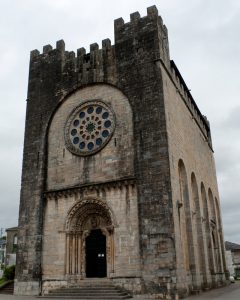
Mojón 63.5 introduces us on a path surrounded by eucalyptus and oak, very prone to embarrassment, which reaches the place of Lacua (Mojón 63). A good row of stone slabs prevents getting angered in the water raft. We continue to San Xulián do Camiño, announced by Mojón 62.5. At the edge of the Camino is the Romanesque church at the end of the XII, which first exhibits the apse.
- Km 3.4. San Xulián do Camiño (Shelter – Bar)
By paved runway we pass the place of Pallota (Mojón 62) and descend without a barracks by a beautiful corridor to the Pambre River to reach Ponte Campana, belonging to the parish of Mato.
- Km 4,5. Pontecamdia (Hostel)
Then there is a spectacular section. Which forest of Fangorn, embraced by rocks and twisted branches, we progress to Casanova, also from the parish of Mato.
- Km 5.7. Casanova (Hostels. Bar from spring 2015)
We left aside the public hostel and later the diversion to the A Bolboreta hostel. We continue along the paved runway and leave it on the left to take a path. We went down to cross the Rego do Vilar, in Porto de Bois (Km 7.2). Then, on the hill, we went to Campanilla, small village of the parish of Mato and the last town lucense on the Camino (Km 8).
On a secondary road we say goodbye to the 96.7 kilometers traveled in the province of Lugo to present us in O Coto, the first Coruñesa village belonging to the parish of Leboreiro, already in the Concello de Melide.
- Km 8.5. O Coto (Bar. Store)
At the exit of O Coto we leave the asphalt on the left to go down to Leboreiro, defined in antiquity as Campus Leporarius or field of the hares. Here we will see a Cabazo: a gigantic canasto that, like the Hórdists, was used to conserve corn. Behind is the interesting church of Santa Maria, Romanesque transition.
- Km 9.2. Leboreiro
We left Leboreiro and crossed the Seco river by a medieval bridge (Km 9.5). The Mojón 56 gives way to Dissicabo and then a tedious section next to the N-547 and the Melide Business Park, also called de la Magdalena (Km 11). A kilometer later, the panorama changes and we go down to the shore of the Furelos River for a more dignified environment. We cross this influent of the Ulla through the medieval bridge and access the parish of San Xoán de Furelos. It is the antechamber of Melide, the capital of Concello.
- Km 13. San Xoán de Furelos (Bar)
We arrived at Lugo Avenue, we passed by the chapel of San Roque and its fourteenth century cruise. Towards the public hostel and to tackle we can continue through the rustic San Pedro but the itinerary is also marked by the rustic do Convento to the plaza do Convento.
- Km 14.8. Melide (All Services)
Here is the old pilgrim hospital, which today houses the Museo da Terra de Melide; the Convento del Sancti Spiritus and its church; the building of the 18th century City Hall and the chapel of San Antonio, next to which we left the plaza to take the rustic San Antonio. After embroidering the public hostel we left Melide for the rustic Principal. Overlooking the valley we go down to the N-547, which we cross to take the CP-4603 in the direction of San Martiño. At the height of a restaurant - parrillada we turn right to visit the church of Santa Maria de Melide, parish of the same name (Km 15,6).
The temple is Romanesque at the end of the XII, has a single nave and semicircular apse and houses the only Romanesque fence in Galicia. After passing the houses of Carballal we are surrounded by eucalyptus, species of deciduous leaves and meadows until the rocky passage of the river Catasol, affluent of the Furelos (Km 17.2). Postal landscape provided by the Camino. For a beautiful setting we head to Raido, at the foot of the N-547. We left his company quickly to continue to Parabispo, already from the Concello de Arzúa (Km 18.7). Under a eucalyptus forest we saved the Valverde Creek, we passed Peroxa- where the Mojón
45.5 is located - and we entered the parish of Boente, left in two by the N-547.
- Km 20.5. Boente (Hostels - Bar)
After the church of Santiago we turn right hand and go down a track to the Boente River and the place of Punta Brea, saving the N-547 by a tunnel. After surrounding a few meadows we face a hard hill that rises to the foot of the N-547, and along with it we reach several places of the parishes of Figueiroa and Castañeda. In this place were the lime kilns where pilgrims deposited the stone they brought from Triacastela.
- Km 22.7. Castañeda
We walk down the paved runway to the Ribeiral Creek, located between Pedrido and Rio (Km 23,3). Now we have to go back and go forward, leaving Doroña to the left. Then, almost always by neighborhood slopes, we go down for two kilometers to the Iso River, which gives access to Ribadiso da Baixo, village of the parish of Rendal.
- Km 25.8. Ribadiso da Baixo (Hostels - Bar)
On the other side of the medieval bridge is the pilgrimage hospital of San Antón, currently restored as a public hostel. Giving a detour, in our opinion absurd, we climbed up to the N-547 to reach, through the endless avenue of Lugo, to the first houses of Arzúa. In the same post there are several private hostels located one after the other. After another excerpt we left the avenue to take the rustic Cima do Lugar, where the audience is.
- Km 28.8. Arzúa (All Services)
The difficulties
Remarks
In images
What to see, what to do
The hostels

¿Do you want to send any photo of "The Camino de Santiago"?
If you have any photos of "El Camino de Santiago" that you want to share with us, you can send them to us and enlarge the photo gallery

Forum: What pilgrims think about the Camino de Santiago
See all