Article translated by an automatic translation system. Press here for further information.
Stage from Fistengen to Muxía to Fisterra
Two-way tour ending in Muxía or Fisterra
Information about the stage 5: Stage from Fistengen to Muxía to Fisterra
Enlarge map
The route
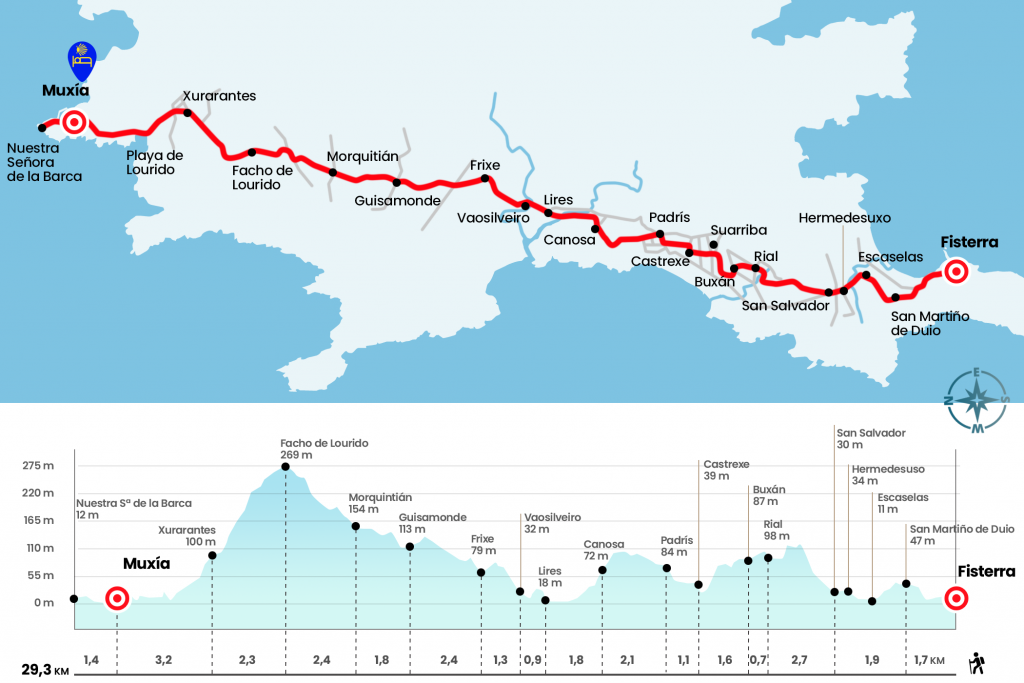
(ATTENTION. We have described the itinerary in the direction Fisterra - Muxia, although the stage can also be done from Muxia to Fisterra, this marked in both directions)
- Km 0. Fisterra(All Services)
We must return to the steps that brought us to Fisterra. From the pilgrim hostel we return back to the beach of Langosteira, but before going down, more or less to the height of the cross of Baixar, we take the road and follow the directions of the first cairn located next to the Arenal hotel. The paved court brings us closer to the parish of San Martiño de Duio. The church, next to the Camino, is a baroque of 1717 and consists of a single nave with a semi-sacristy. The name of Duio refers to the legendary city of Dugium, submerged under the waters and place that the disciples of Santiago visited to request the burial of the Apostle, according to quote the Codex Calixtino of the 12th century.
- Km 1.7. San Martiño de Duio
Giving a small rodeo we passed through Scarelas (Km 2,8) and reached Hermedesuxo de Baixo, which we see on the left hand (Km 3,6). At this point the road departs to the right to San Salvador and goes through the forest to Rial (Km 6.3) to get off to Buxán (Km 7). It then heads towards Suarriba, on the right hand (Km 7,9), and Castrexe (Km 8,6). By clue of concentration he approaches Padrís, the last of the series of villages belonging to the parish of Sardiñeiro.
- Km 9.7. Padris
In this village the variant comes from the beach of Cara and we can see the Atlantic preceded by corn and pine crops. Right at the exit we enter a path excavated between the ferns that divide the vines of pines, a beautiful section that ends in Canosa, where we have a merendero (11,8).
We retake the descent to Lires glued to the river and by good dark sections. On the way to this parish in the Community we must pay close attention to signposting. At the entrance of Lires we see the temple of San Estevo from the beginning of the seventeenth century and overcome it we turn right next to a rural house. There is more than one accommodation in Lires and also bars. In this locality you have to seal the credential if our intention is to sleep in the hostel of the Xunta. Let's walk up the population and leave the diversion to the bar on the right. It is the only locality of the stage with services so it is almost obligatory to renew forces in this locality.
- Km 13.6. Lires(Accommodations. Bars.)
The itinerary leaves Lires and goes down to the Castro River. Until early autumn 2010 pilgrims had to save him by some stone trunks, but in 2010 a stone bridge was built that saves this conflicting point. Manuel Vilar Álvarez in his Trip at the end of the Earth recalls that “toponymy in this area makes clear reference in the past to the crossing of the river in boat: Agra das Barcas and Agra de Tras das Barcas Vellas”. The other side of the stream already belongs to the Concello de Muxía and, eye, 70 meters away the Camino departs to the left and visits Vaosilveiro (Km 14,5).
After a short walk we enter a paved runway that leads us to Frixe (Km 15.8), where a place covered with vending machines, with tables and bathrooms has been enabled. The bulk of the population is left to the right and we turn left to take a clue between a pine tree. Later we crossed a road – the official signs mark 12 kilometers to Muxía – and we resumed the track to Guisamonde (Km 18.2). Here the asphalt returns and continues, on the rise, to the house of López and a cruise and fountain that welcome us to the Muxian parish of Morquintián. The route does not visit directly the church of Santa Maria and continues along the road.
- Km 20. Morquintián
Just over a kilometer after Morquintián comes a point with dual signaling. Beware! When you reach a junction, there is a bifurcation: an official cairn leads to the left towards a variant that is not signalized later on.It is most prudent to continue right following the yellow arrows painted on the asphalt. At 350 meters the itinerary departs on the left and already takes a clear path that goes up to the nearby Facho de Lourido, the highest level of the stage at 269 meters. This is a very busy section, but at this stage it is already beginning to weigh. The Galician voice facho signifies the stake and the place or watchtower where it is turned on to warn about some danger (Km 22.4).
A broad road descends to the next village:Xurarantes (Km 24,7). At the exit we take a neighborhood track and pass by the Bico fountain. Right away, when you get to the road, there's another hurdle with the signals. In front of it, arrows encourage you to get into a path. It goes down directly to the beach of Lourido after a short stretch of dunes, but once there you have to climb unreservedly to the road. The official route, the option we recommend, follows the road and borders the beach above (Km 26,1). Until Muxía there is no loss. As soon as entering Muxía the signs guide us to the public hostel, turning right by the rustic Campo das Pinas and the rustic os Malatos and Enfesto (Km 28).
- Muxía(All Services)
Once accommodated in the hostel (there is also another private hostel next to the Tourist Office), tradition pushes to visit the Shrine of the Virgen de la Barca, ravaged by the fire that took place on Christmas Day 2013. You have to go down to Manuel Lastres street and here turn right to Real Street, which we follow on the left. On the way to the Shrine we can enter the tourist office, where we can pick up the Muxiana. Then we find the church of Santa Maria, which occupies the lower part of Mount Corpiño and presents traces of the Romanesque transition and the Gothic. Half a kilometer later is the Shrine. The origin of a chapel in this place can be traced back to the 11th or 12th centuries, but the first document referring to the Shrine is 1544. The current temple is a baroque 1719 of a single nave. In the surroundings are the Pedra de Abalar, the Pedra dos Cadrís, the Pedra do Timón, which relate to the legend of the arrival of the Virgin on these shores in a stone boat and his appearance to the Apostle Santiago to encourage him during his preaching (Km 29,3).
The difficulties
Remarks
In images
What to see, what to do
The hostels

¿Do you want to send any photo of "The Camino de Santiago"?
If you have any photos of "El Camino de Santiago" that you want to share with us, you can send them to us and enlarge the photo gallery
Forum: What pilgrims think about the Camino de Santiago
See all