Article translated by an automatic translation system. Press here for further information.
Olveiroa to Muxía Stage
Stage take the first 23 kilometers to San Martiño de Ozón
Information about the stage 4: Olveiroa to Muxía Stage
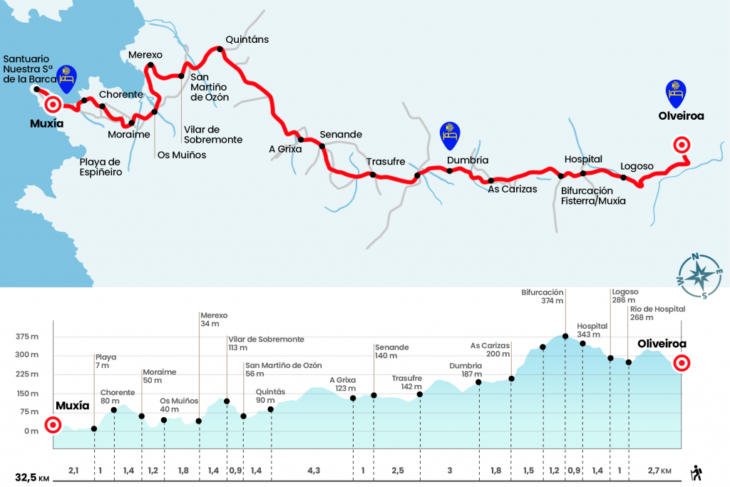
Enlarge map
Points of interest in the stage 4: Olveiroa to Muxía Stage
The route
- Km 0. Olveiroa(Hostels. Bars)
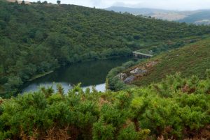
We descend the street of the hostel and turn right to leave Olveiroa on the paved runway. Attention must be paid because in short, at the height of the Cairn 34,558, we must turn left to cross a stream and take a fitted path that leads to the Castrelo reservoir. After a curve, we take, on the right, a path that goes up a line of wind turbines. Later on we left this path and advanced along the hillside of the mountain with incredible views of the Xallas River, which flows embedded by a dense vegetation. We ended up descending to the place of Vao de Ripas, where we crossed the river of Hospital by a stone bridge (Km 2.7). We saved a hill and entered Logoso, a
village located on the slopes of Monte Castelo.
- Km 3.7. Logoso(Store-Store. Bar)
We went through this small place and boarded a shuttle to the village of Hospital, where we took the road CP-3404 (Km 5.1). A few meters away there is a bar on the left. After the bar we cut off a bit on the old road to get to the roundabout where the cairn is located that forks the roads to Fisterra and Muxía.Visit stage 3 for the route to Fisterra!
- Km 6. Fisterra and Muxía
We continued forward to Muxía through the arcén of the DP-3404 and accompanied by the giants of the wind park. After 1.1 kilometers we left the road through the left wing, right on the official sign that marks 25,880 kilometers to Muxía, and we went down a few meters abruptly to cross the rego of Vao Salgueiro, tributary of the Fragoso river (Km 7.2). About 400 meters later we cross the road again to take the road that comes out of the front and that will save us several sharp corners of the road. The route returns once again to the asphalt for 200 meters, precaution in this section, and leaves it on the left to descend to As Carizas, village of the parish of Santa Baia de Dumbría (Km 8,7).
- Km 8.7. As Carizas
We turn right onto the main street, cross the paved runway and take a rural road that leads to the sports area of Dumbría. We will be struck by an avant-garde construction with coloured volumes. It is the pilgrim hostel opened in 2010 and financed by Inditex (Km 9.6). After the sports area of O Conco, with large landscaped and resting area, we went to the road and turned left to pass the Cheo rego and climb to Dumbría.
- Dumbría(All Services)
As soon as we enter, we see the square with a nice hórreo, a cruise, the church of Santa Eulalia – from the 17th and 18th centuries and keeping the cover of Romanesque style – and the rectory house. As the capital of Concello it has bars, shop, ATM, Health Center, etc. The population is driven by DP-3404 and has been crossing it for over a kilometer. At the height of the Health Center of Dumbría (Km 10.7) we continue on the left and descend on the road that saves the Fragoso River.
We immediately went out to the AC-552 (A London-Fisterra), (we crossed it with great caution because this is a black point where there have already been several accidents, even recently a pilgrim died, there is a study to avoid it doing a lower step), and we link with the path that was born from the front. A road, at first by a flat fluffy and then always on gravel, channeled by stone murets and surrounded by a sort of low mountain, some pine and eucalyptus without order or concert. It takes us in two kilometers to the village of Trasufre, of the parish of San Pedro de Coucieiro and already belonging to the Concello de Muxía. It houses the chapel of Nuestra Señora del Espino, where every third weekend of September the romers go to heal their warts in the fountain (Km 13,5).
- Km 13.5. Trasufre
The official signage surrounds the town and continues along the street track. Enveloped by the cultivation fields we see on our right the village of Calo and continue to cross the Castro River, almost hidden by the riverside forest. It travels over 30 kilometers from Monte Escaleira to the Ría de Lires. Next to it are the Casas da Ponte and we take the paved track that leaves to the right, where is the sign of the 18,734 kilometers to Muxía. For this reason, after several nine-degree turns, we reach Senande, who welcomes us with the eternal figure of agricultural Galicia: the Hórreo. Senande is the largest nucleus of the parish of San Ciprián de Vilastose and is located in the equator of the stage. On the right hand is a bar and later a store.
- Km 16. Senande (Bar. Store)
We turned left towards Agrodosío, Vilastose and Casanova. We passed the first scattered nucleus and headed towards the place of A Grixa, where we see the parish church and on the other side the spaghetti, isolated on a wall (Km 17). Next to A Grixa, we turn left at the level of the private hostel by the neighborhood road and do not have to wake up because at 250 meters you have to leave the track on the right and take a road. The official cairn may be partly covered by vegetation. Now begins a comfortable section of about 4 kilometers by road and forest track that crosses the mountains of Vilastose and Raposa and leads to Quintáns, town of the Muxian parish of San Martiño de Ozón. On the right hand we salute the chapel of Saint Isidro, cross the AC-440 and turn left on the plaza. Several bars allow you to pause again.
- Km 21.3. Quintans (Bar. Store)
We visited Quintáns from end to end and after a cowboy we advanced through paved slopes and dirt overlooking the valley where Ozón sits. A herbose section and a short step along the path of the Camino Real (bar on the left hand) climbs to the whole of the hórreo and church of San Martiño de Ozón. The Hórreo is one of the largest in the whole of Galicia, based on 22 pairs of feet and measuring more than 27 meters (Km 22,7). We left the church on the right to climb to the neighboring Vilar de Supermonte. In this short section we can see the route traveled from Quintáns.
- Km 23.6. Vilar de Supermonte
In the same Vilar el Camino it enters again on the mountain and after an initial hill, plains and descends peacefully to Merexo (Km 25). On the other side of the estuary formed by the mouth of the Rio Grande we can see Camariñas. The main core of Merexo remains on the right and we take the local road for a kilometer and a half to approach Os Muiños. In the middle of the population we crossed the Black River and after the bakery we left by the road.
- Km 26.8. Os Muiños(Bar. Store. Pharmacy)
After the pharmacy we continue right towards Playas de Os Muiños. Six hundred meters later, next to a house, we turn left and we go up a herbose road (it may be uncleaned and the vegetation may reach the waist) to the road and the Romanesque church of San Xulián de Moraime (Km 28). It consists of three naves and three apses and beautiful side covers full of details. Inside, some murals of doubtful dating were parked and divided into eight canvases. The day continues through the site of Casas Novas and continues to climb to the AC-440, which we cross with caution to reach Mount San Roque and its chapel (Km 29).
We immediately enter Chorente and when we reach the last houses we take a path between ferns. About 600 meters later you have to twist to the left, there is a Jacobean cairn not very well located, and take the narrow path that descends to the beach of Espiñeirido (Km 30.4). At this point you can continue along the paved runway or the wooden walk
that borders the beach. We choose this last option and end in the AC-440 at the entrance of Muxía (Km 30.8). We enter through it and past the Hostal La Cruz there is a sign next to the left arche that guides to the hostel of pilgrims, on Enfesto Street.
- Muxía(All Services)
To reach the Shrine of the Virgen de la Barca, ravaged by a virulent fire on Christmas Day 2013, we always go ahead along the promenade, next to the fishing and sports ports, and in the center of the population there is a sign that leads us to the Tourist Office, and the Shrine. On the way to it we pass by the church of Santa Maria, which occupies the lower part of Mount Corpiño and presents traces of the transitional Romanesque and the Gothic. It houses the Gothic Chapel of the Rosary in the 14th century. Half a kilometer later we arrived at the Sanctuary the Virgen de la Barca. The origin of a chapel in this place can be traced back to the 11th or 12th centuries, but the first document referring to the Shrine is 1544. The current temple is a baroque 1719 of a single nave. In the surroundings are the Pedra de Abalar, the Pedra dos Cadrís, the Pedra do Timón, which relate to the legend of the arrival of the Virgin on these shores in a stone boat and his appearance to the Apostle Santiago to encourage him during his preaching (Km 32.5).
The difficulties
Remarks
In images
What to see, what to do
The hostels

¿Do you want to send any photo of "The Camino de Santiago"?
If you have any photos of "El Camino de Santiago" that you want to share with us, you can send them to us and enlarge the photo gallery

Forum: What pilgrims think about the Camino de Santiago
See all