Article translated by an automatic translation system. Press here for further information.
Santiago de Compostela to Negreira
The first day, a few kilometers, goes into the rural environment
Information about the stage 1: Santiago de Compostela to Negreira
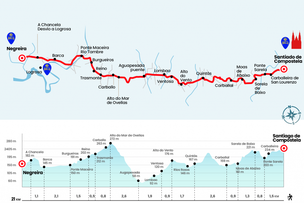
Enlarge map
Points of interest in the stage 1: Santiago de Compostela to Negreira
The route
“Behind is the stony panorama of the dreamer urbe and the landscape of the Mahia is developed, low land, leafy, covered with pine trees, jalonada de esmeraldinas riberas con saltarines regatos y boscajes umbrosos y deleitables.” Thus begins Luciando Huidobro and Serna chapter VII of volume III of The Jacobean Pilgrimages, from the middle of the twentieth century, in which he narrates the road from Santiago to Finisterre. Apart from the passing fad and the tourist claim, even more than one might think, the extension to Finisterre has been a reference for pilgrims and travellers throughout history. The rock rock rock that plunges into the Atlantic, the end of the world once known, continues to act as a balm of concerns and a source of answers for those who decide to continue their path, perhaps with some uncertainty, beyond the city of the Apostle. More than an extension of the road is an epilogue, a final part for reflection that closes the circle and gives more meaning to the pilgrimage.
- Km 0. Santiago de Compostela(All services)
A penultimate look at the cathedral and let us turn to the rustic das Hortas, between the Hostal de los Reyes Católica and the pazo of Raxoi. We don't go home, we walk back to sunset. We descend straight down this street next to the church of San Frucutoso, characterized by four sculptures representing the cardinal virtues. Das Hortas extends with the rustic Campo das Hortas and after a pedestrian crossing we continue in front of the rustic do Cruceiro do Galo, which is renamed Poza de Bar and later San Lourenzo. It brings us to the carballeira of the same name, an ancient robles front where the Franciscan convent of San Lorenzo de Trasouto, today converted into pazo and destined for social celebrations. In this location we find the first Jacobean cairn that indicates the distances to Fisterra and Muxía. One of the road trips reaches the Costa do Cano, which descends to Ponte Sarela. After crossing the river we can still see in ruins and conquered by the hihedron the old tanning plants (Km 1,5). A narrow path, a gift so close to the city, brings us closer to the trail leading to Sarela da Baixo, where, if the day is clear, we will see the Compostelan Cathedral look back on this road for the last time (Km 2,3).
- Km 2.3. Sarela da Baixo
At the Cairn 86,722 we turn right and resume the journey through a path that flows under the eucalyptus. Manuel Vilar, in his most recommended title ‘El Camino al fin de la Tierra’, tells us that an almost octogenarian neighbor told him that this road was used by the dairies of Villestro to go to sell to Santiago. The forest ends up at the level of the uni-family members of Moas de Abaixo, the place of the parish of Santa Maria de Figueiras that we left by the left (Km 3,6). We advanced by asphalt to the heart of Carballal, where we entered the parish of Villestro (Km 4,5).
At the outset of the population, there is a section of soaked rise of eucalyptus. Pedregoso first and earth without compacting later, it will not be strange to see more than one hunter training the dogs for parts. Already low and by paved runway, at Mojón 82,306, we enter the center of Quintáns, of colorful houses and an excellent viewpoint over the valley (Km 7.1).
We left the nucleus after several changes of direction and arrived on a paved line to the medieval bridge over the Roxos River, a nice corner with several tables to rest at the shelter of the sun, although the first possibility of snack is very close. Without interruption and just effortlessly we planted in Alto do Vento, where there is a bar-restaurant. At this point we left the cello of Santiago to enter the one of Ames.
- Km 8.8. Alto do Vento(Bar)
Ventosa is the first nucleus of the parish of Covas, which we reached in a sigh on the sidewalk of the AC-453. We left this road to cross part of the population and crossed it later to finally return to it at the height of Lombao.
Following the AC-453 we left on both sides the deviations to Bertamirans, Ameixenda and Castelo, and we dropped to Augapesada. The itinerary forces us to leave the road to pass by the bridge over the rego two steps, a restored medieval one eye (km 11,6).
- Km 11.6. Augapesada(Bar-Shop)
After crossing road CP-0204 – there is a supermarket bar on the left – we started to taste the strong dish of the day: the rise of Mar de Ovellas, which follows the Camino Real trace and presents 215 meters of elevation. Cyclists are advised to climb the road.
As soon as the road begins there is a stone bank, perfect to adjust the backpack and take a good drink before the effort. Calm down, because along the climb there are some more. Thrown by the stand, we're feeling the first whiplash of the hill, which also lets us breathe during some sections. The first and a half kilometres we do it by road and at the height of a water tank we go to the road, which helps to soften the harshness of the ramps. We crowned the upper Ovellas Sea eight hundred meters later (Km 13,8).
We go down the same road entering the parish of Trasmonte de Ames. We passed the center of Carballo (Km 14.2) and Trasmonte, with bar next to the itinerary.
- Km 15. Trasmonte(Bar)
Soon we cross the places of Kingdom (Km 15.5) and Burgueiros (Km 16.2). The asphalt leads us to the Tambre River, which separates the nucleus of Ponte Maceira and serves as a division between the Concellos of Ames and Negreira. On this side of the river the terrace of a bar provides an excellent panoramic view of the magnificent medieval bridge. Known locally by the name of Ponte Vella, it is the end of the 14th century and fell down several times due to the Tambre's onslaught. On the other side of the bridge is the chapel of Carmen or San Blas. As Manuel Vilar points out, it is called interchangeably. It is from the 18th century and in the middle of the 20th century the semicircular apse was attached to it. On his right is the pazo of Baladrón, also built between 1945 and 1955.
- Km 17. Ponte Maceira(Bar)
After Ponte Maceira we took a tree-lined path near the river that finally planted us in the AC-447, through which we entered Barca (Km 19.1). We leave the road on the left to face a hike up to A Chancela (Km 20,2), On the left is the diversion to Logrosa, where there is a private hostel and the pazo known as Casa do Captain.
- Km 20,2. A Chancela(Hostel at the foot of the Camino and Hostel 700 meters in the diversion to Logrosa)
The itinerary continues from the front to enter Negreira. We will first find the indications to private hostels. In order to reach the public hostel, it is enough to follow the path. You have to cross Negreira (Km 21), pass by the chapel of San Mauro and the pazo of Coton, cross the river and go up the road.
- Km 21. Negreira(All Services)
The difficulties
Remarks
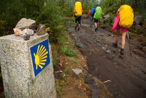
In images
What to see, what to do
The hostels

¿Do you want to send any photo of "The Camino de Santiago"?
If you have any photos of "El Camino de Santiago" that you want to share with us, you can send them to us and enlarge the photo gallery
Forum: What pilgrims think about the Camino de Santiago
See all