Article translated by an automatic translation system. Press here for further information.
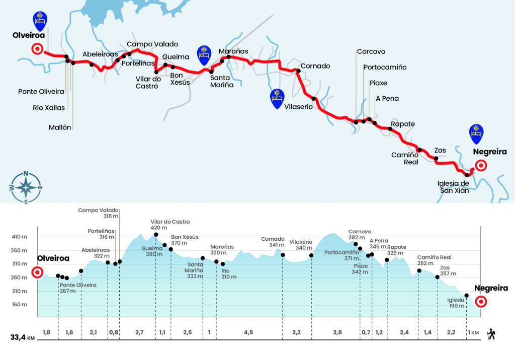
Stage from Negreira to Olveiroa
Complicated stage from Negreira to Vilaserío, with 12.7 hard kilometers
Information about the stage 2: Stage from Negreira to Olveiroa
Enlarge map
Points of interest in the stage 2: Stage from Negreira to Olveiroa
The route
- Km 0. Negreira(All Services)
We moved away from the center of Negreira through the career of San Mauro, passing under the arc that communicates the chapel, from the 18th century, with the pazo of Coton, of uncertain origin and with quite a few additions from the 18th to the 20th centuries. On its facade you can see a dozen arms shields belonging to the families that inhabited it. We cross the Barcala River, (note here because there is a bifurcation, well signposted to go to the right as soon as you pass the bridge through a river promenade and so take off dangerous road arches, the two roads come together near Zas after 3 kilometers. Right after we took the road that ascends to the place of Negreiroa, the small village where the public hostel is located, the parish church and which was the original nucleus of Negreira. The road must be left on the right and passed by the church of St. Julian, 18th century (Km 1).
We welcome a good boscose section of deciduous sheet that ascends to the upper da Cruz and goes back to the road (Km 2,3). A line of about 600 meters leads to San Mamede de Zas, where the road is left again to cross the village. At the exit comes a nice stroll surrounded by stone walls and surrounded by varied vegetation. Water rafts are easily formed in this section. The itinerary roams the core of Camiño Real, which we left to the left.
- Km 4.6. Camiño Real
A small break for the nearly two-and-a-half mile stretch to the next village, up and with some slides at the end. Arrived at Rapote (Km 7), village of the parish of San Martiño de Broño, we went down to a stream and recovered the lost meters on Monte de Espñareiro to A Pena. At the entrance is the diversion to the bar and the attached hostel.
- Km 8.2. A Pena(Hostels. Bar)
After the church of San Mamede and the rectoral house enters Piaxe (Km 8.4). Half a kilometer later we left on the road DP-5603 at the height of Portocamiño (Km 8.9) and we continued through it to Cornovo (Km 9.3) (at this point we will find a well-marked bifurcation that on the right would take us to Vilaserio by dirt road and without prolonging the stage, no doubt advisable). On the left the official route at the exit of Cornovo, after crossing to Gorgal and Xallas, leaves the asphalt company again and reaches a small walkway that saves the rego of Forxán. The day runs through the Altiño do Coton site in an environment where tojos, maizales, pines and eucalyptus are mixed and return to the road. A heavy section of asphalt of more than two kilometers leads to Vilaserío, village of the parish of San Pedro de Bugallido with bar and a couple of hostels, one public and the other private.
- Km 12.7. Vilaserío(Hostels. Bar)
We left Vilaserío and continued along the road to Corming, the last town of Concello de Negreira (Km 14.9). From this village the landscape will change radically due to the parcels concentration. A small echo and its subsequent runway down where we can see a herd of cows between the pine forest lead to the road DP-5604, which we follow on the right for 400 meters. We leave it on the left and then, after passing some section prone to getting stuck due to the proximity of the Barbeira River, we will find an agricultural track wrapped by corn crops.
About 40 or 45 minutes later we reached the bridge over the Maroñas River. We cross it and enter the parish of the same name, of the Concello de Mazaricos and marked with a wooden sign (Km 19,8). At the entrance we are greeted by two typical Hórges and continue along the road to Santa Mariña (Km 20,8). At the height of the cruise we can turn left if we are going to stay in Casa Pepa hostel, with restaurant bar. The Camino continues to the right in search of the road AC-400. It must be crossed with great care as cars move at great speed. On the other side is the bar and hostel Santa Mariña (Km 21,5).
- Km 21,5. Santa Mariña(Hostel. Bar)
Three hundred meters after the hostel we leave the general on the right and we take a paved runway that picks up to Bon Xesús (Km 23,3) and Gueima (Km 23,7). From this village we overcome a good repecho to Vilar do Castro (Km 24,4), (at the entrance of Vilar do Castro we will find some green arrows with directions to "Picota City", these green arrows go to the place of A Picota, which has hostel and services, and which only have to be followed if you are going overnight there. This diversion extends the journey by one and a half kilometres).
- Km 24.4. Vilar do Castro
When we reach the first houses we turn 180 degrees to the right to take a paved track that goes up to Mount Aro, a little less than a kilometer we will join another dirt track that goes up from Gueima to the little turn left by a dirt track that leads us to a viewpoint, nice place to rest in their banks, we continue towards the top, but 500 meters before arriving we turn to the land on a holiday From a closed curve we arrived to Lago, where the cafeteria shop Casa Xalleiro is located. We then visited Campo Valado (Km 27.1), Porteliñas (Km 27.4) and Abeleiroas.
- Km 27.9. Abeleiroas
Next to the diversion to the viewpoint of Corzón we turn left and approach to the parish church of San Cristovo de Corzón, sober rural construction with elements ranging from the Romanesque to the neoclassical.
- Km 30. San Cristovo de Corzón
Instead of entering the town we turn left to face a line more than a kilometer to the center of Mallon (Km 31,2). We turn to the right to take a more relevant road and we reach the bridge over the Xallas river that divides the Concellos de Mazaricos and Dumbría. In this same place, in 1809, the Galician labriegos tried unsuccessfully to curb the progress of French troops. On the other side is Ponte Olveira.
- Km 31.6. Ponte Olveira(Shelter Bar)
Until the end of the stage there are about 25 minutes left. You have to follow the road, no loss, and move to the centre of Olveiroa. In the center of the village is the hostel of the Xunta, it is distributed in several buildings: the old schools, private houses, several hórges, a merendero and the place of reception.
- Km 33.4. Olveiroa(Hostels. Bars)
The difficulties
Remarks
In images
What to see, what to do
The hostels

¿Do you want to send any photo of "The Camino de Santiago"?
If you have any photos of "El Camino de Santiago" that you want to share with us, you can send them to us and enlarge the photo gallery
Forum: What pilgrims think about the Camino de Santiago
See all