Article translated by an automatic translation system. Press here for further information.
Phase from A Coruña to Bruma Hospital
Itinerary that starts in the Romanesque church of Santiago de A Coruña
Information about the stage 7: Phase from A Coruña to Bruma Hospital
Enlarge map
The route
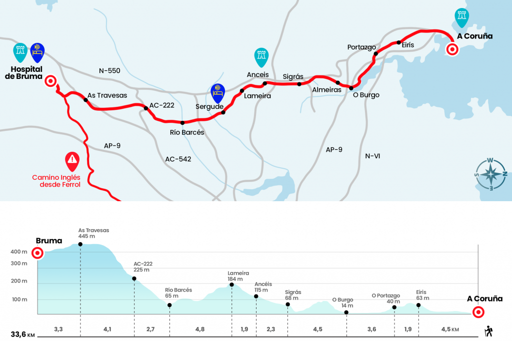
The itinerary begins, it could not be otherwise, in the church of Santiago de A Coruña, an example of the Romanesque of the 12th and 13th centuries on which the oldest guilds of the city were established and where the Council met in the Middle Ages. In the eardrum of the cover there is sculpted an image of Santiago on horseback and in the interior another polychrome of Santiago peregrino that is worth contemplating. From Santiago Street we descend through Puerta Real to Avenida de la Marina. Next to the gardens of Méndez Núñez, where the Tourist Office of Galicia is located, we cross the Big and Small Canton, with its magnificent galleries, which collect the light of the Atlantic and distribute it all over the corners. Always from the front, having the docks and docks on the left, we continue along Sánchez Bregua and Linares Rivas Avenue. At the end of the latter turn left to continue along Fernández Latorre and Marqués de Amboage street (Km 2.7).
It links to Calle de los Caballeros (on the left we left the bus station, a good reference), At the end of this route there is a Jacojón beo, not well positioned, that leads us to climb the avenue of Monelos. After 700 meters we reach a roundabout and continue on the left towards Eiris/Santiago. We continue another half a kilometer through Monelos and, look!, we turn 90º to the right to cross the place of Eirís (Km 4,5) .
Taking care of some arrows on the ground, we will turn left by the place of Monte Mero to go down to Pedralonga Avenue. We go down to the right to take the common section with the N-550 that leads us to O Portazgo, the first nucleus of the Concello de Culleredo (Km 6.4) . Soon after p.k. 4 of the National, we turned 90º to the left by the rustic Río de Quintas. The next piece is badly marked! You have to take the second street to the right, that of Eduardo Blanco Amor, and then keep going down the street of the left, Jorge Guillén. At the foot of the AC-211-Avenida de Fonteculler we crossed it in front and 80 meters later we reached the walk of the Ría do Burg, where another Jacobous mojón welcomes us (Km 7.2) .
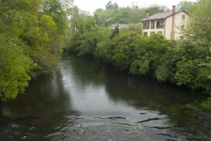
The ria means giving a long rodeo, but we must stick to the pilgrims who preceded us. Many Jacobean landings also took place in this estuary, the mouth of the river Mero. Luciano Huidobro points out that "his name, Burgum Fari, as quoted in documents of the 12th century, comes from being a population founded in the territory of the Faro, as it was then called the current Coruña". He also cites that here the Templars were established, favored by the lords of Traba and that founded the Puebla del Burg and its church of Santiago, which we will see something later. It will take us a half-horite, after which we will reach the population. At the entrance it is interesting to stop by the medieval bridge, probably from the 14th-15th century, located on the left hand (Km 10) .
We then visited the church of Santiago, with its three semicircular apses and baroque cover of the 18th century. A lot of eye!, right past the bridge of the tracks you have to deviate 90º to the left by the street of the Hill (we can enter first to the core, which has bars and shops and return to this point). It runs parallel to the tracks and turns right onto Pablo Picasso's street. We go up to Galicia Avenue, where we turn left, and we go under AP-9. Through the streets of Los Pelamios and Eladio de la Iglesia we cross the place of Carcebelo. San Xiao Street faces the last echo to the church of the same name, parish of Almeiras (Km 11,3) .
A statue of the Knight of Almeiras is erected in the resting area, which represents the figure that adorned a tomb of the 15th century and was found in the temple. From this teso there is a good view of the estuary of O Burg and A Coruña. We continue along the street track, setting aside the sports club, crossing the site of A Choeira and passing to Alvedro. A few 400 meters to the right is A Coruña airport. A lot of attention! , here in Alvedro, in the rua of Archbishop Xelmírez, you have to turn 90º to the left (if we reach the brewery La Nou we have passed the crossing). The track surrounds the Alvedro Castro and picks down to the Alvedro Business Park, parallel to the N-550. After the cement and the streets of the alphabet, we take a way to cross the river Valiñas through the medieval bridge of A Xira (the arch is under the road and can only be distinguished from a side) (Km 13,6) .
We passed this way to Concello de Cambre. We cross the AC-214 front in the place of A Xira, place of the parish of Santiago de Sigrás (next to the road there is a bar). We also continue from the front where it indicates College Torrente Ballester and ascended through the place of Sigrás de Abaixo. When we reach a cruise, the signs make us turn right and we arrive at Casa Atocha, located in the place of Sobrecarreira. A few meters away we meet the church of Santiago de Sigrás, a milestone on this day. The complex consists of the 1867 cruise, the church - which retains Romanesque elements despite the reforms - and the rectoral house that once was a pilgrim's hospital. The place invites to rest (Km 14,5).
We walk down the streets to cross the DP-1702, already in the territory of San Juan de Anceis, another of the parishes of the Concello de Cambre. One road leads to the passage over the A-6, next to the N-550. We desmarcate the national by the neighborhood court, visiting the places of A Rocha and O Drozo. On this site we will stop by the pazo of O Drozo and the fountain of San Antonio, where we have marked the intermediate point of Anceis, the exact equator of the stage (Km 16,8) .
After the Plaza de San Marcos the English Road rotates to the right, combining neighborhood tracks with some thankful stretch of land. He thus leaves the Concello de Cambre to enter Carral's. The first place is Lameira, from the parish of San Martiño de Tabeaio. Recognizable because at the foot of the Camino is the bakery Da Cunha, another suitable place to drop the backpack (Km 18,7) . The Concello de Carral also has in the bread its star product, which transcends borders. Then we go down to the rest area of Lameira, with banks and fountain and located in a walled enclosure. A little later, after a slight rise leading to the crossing of Corpo Santo, the left is followed towards Belvis and Sergude. The valleys of Brexa and Barcés await us.
For a good section of the neighborhood road you leave the parish of Tabeaio to enter the parish of San Xián de Sergude. The pilgrim hostel of the Xunta opened in July 2014 is at the foot of the route. Also the bar-pond Casa Adolfo. We go down to the River da Brexa and as soon as we cross it we leave the road on the right, overcoming a strong gap. Go up to O Penedo, the parish of Santa Baia de Cañás. One track takes us to the place of A Atalaia, where we cross the AC-0106 (Km 22.5). . For a section of land, very few so far, we enter the Concello de Abegondo, parish of Sarandóns. We got to the place of Aquelabanda. Before crossing the Barcés, there is the Bar Centro (Km 23.5).
The chapel of San Juan gives way to the river Barcés and to the place of Calle. At this point begins the hardest section, not only of the stage but of the whole Camino. To start a long ascent by asphalt passing through Bordel. Reaching the AC-222 will take us more than half an hour (km 26,2). So we returned to the lands of the Concello de Carral. We immediately left the road on the left. In Peito (the Xacobeo mojón indicates 48,173 km to Santiago) the level does not give respite, even more, hardens. The radio antenna located several kilometers above becomes the manna. We go to the AC-542, already in the Concello de Abegondo, which we leave through the left arche. A clear road, which then becomes a simple road over the meadows, reaches a spectacular tunnel of laurels that dies on the road in the place of As Travesas. Here is the bar-pond Casa Avelina (Km 30,3).
The stage gives its last stitches through the arcén of the AC-542. Just past the electric substation we left the road on the left and lined a plot line. It will be when we turn right when we join the English Way that comes from Ferrol (the cairn has an vieira on each side). In the final section we saved the rego two Outeiros and turned to the right to approach to the place of Bruma Hospital. The parish of Bruma is administratively owned by the Concello de Mesía but is nestled as an island in Ordes. The pilgrim hostel of the Xunta, the first that was built on the English Way, is built on the site of the old Pilgrim Hospital, founded around 1140 and annexed in May 1175 to the cathedral of Santiago (Km 33.6) .
The difficulties
Remarks
In images
The hostels

¿Do you want to send any photo of "The Camino de Santiago"?
If you have any photos of "El Camino de Santiago" that you want to share with us, you can send them to us and enlarge the photo gallery
Forum: What pilgrims think about the Camino de Santiago
See all