Article translated by an automatic translation system. Press here for further information.
Linyola to Algerri stage
From Balaguer the route is complicated with a level of 130 meters
Information about the stage 5: Linyola to Algerri stage
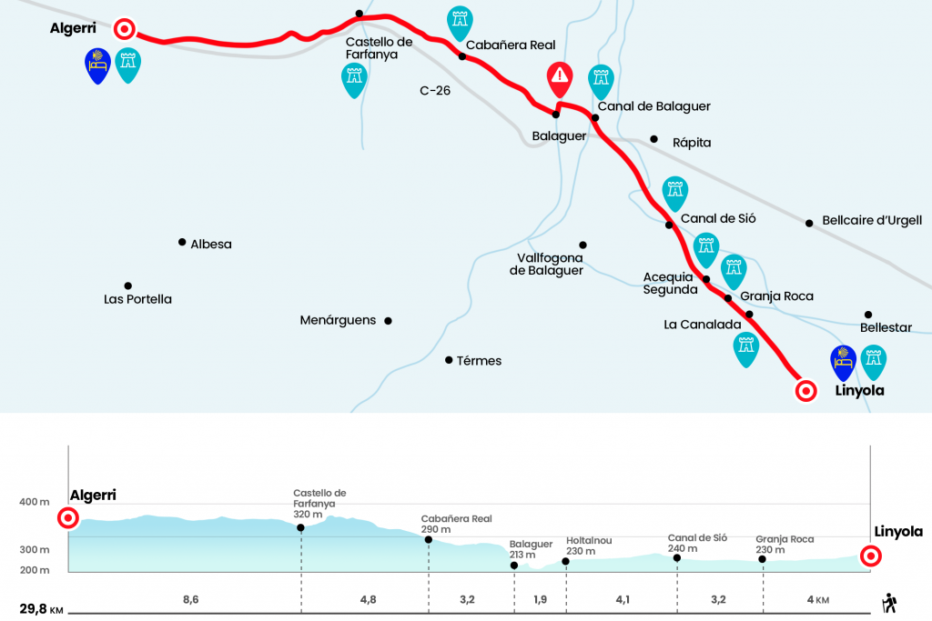
Enlarge map
Points of interest in the stage 5: Linyola to Algerri stage
The route
From the Church of Santa Maria we go down Calle Mayor to Pons i Arola Street (there is a branch of Ibercaja), which we follow on the right to link in front of Ramón Formiguera Street. We followed it for 350 meters to the outskirts of Linyola, where we turned left onto the Balaguer Road, a wide track that advances like a bourbon. The morning melody of the Pla d’Urgell may be tarnished with the passing of a vehicle. The Camino de Santiago follows Balaguer and leaves to the right the path of the Senyoret that goes to Bellcaire d’Urgell, the crossing is well marked.(Km 2).
A kilometer later we passed over La Canalada, a camouflaged canal between vegetation and crops (Km 3.1), and we continued forward at the crossroads that are 200 meters away. Several masías and naves, such as the Roca farm (Km 4), break the green and flat line. A kilometer away the Second Acequia for a small stone bridge (Km 5) and continues to draw a curve. The panorama remains unshaken and the next milestone is the Sió Channel (Km 7.2), which we saved by a bridge before being announced, probably, by a pack of small dogs guarding the farmhouse. After a slide you see Balaguer in front, with the rugged Gothic church of Santa Maria, nicknamed ‘Lo Campanar’, wagered as a giant and dominating the scene. On the right is the population of La Ràpita. We crossed the Sió channel for the second time to embolden, there is no other, with a line of almost two kilometers. The arrows of the real yellow number 529 place us next to a road (km 10.6).
We traverse it very carefully, and we continue on the right hand under the bridge, at the exit of the bridge we fold left and we cross a polygon. We are in l’Hostalnou, a small nucleus of Vallfogona de Balaguer. After a mini roundabout we went to Prat de la Riba Street to cross the Balaguer canal (Km 11,3) and put our feet in the capital of the Noguera. There is no loss, you have to throw in front of Urgell Street for 1.2 kilometers, including a step over the roads, to the Sant Miquel bridge over the Segre, which until the end of the 19th century connected with one of the portal of the wall. We cross the Segre and follow left, by the river. At 250 meters we take on the right sidewalk the street of Sant Jaume and continue along the street d’Avall, partially porticated and full of small shops. It gives to the Plaza del Mercadal, the meeting point of the citizens and medieval enclave, also porticated, where the market is still held every Saturday (Km 13,2).
Beware! on the plaza. Right at the entrance you have to turn 90º to the right (see signs on the ground) and follow the supports towards the street of the Botera. If we cross the front plaza we could meet with arrows that lead to another route that follows the course of the Segre and that will move us away from the Camino de Santiago (more than a group of pilgrims has already been lost). We retired from the capital of La Noguera by the pronounced street of the Botera to the Gel portal, the best preserved of those existing in the old wall. This construction dates back to the 10th and 11th centuries and was communicated by three castles. We continue, from the front, along the street of the Wall. In the end, at the height of the cemetery, we deviated slightly to the left facing towards a paved line where the signage of the banderoles indicates 7.1 kilometers to Castelló de Farfanya. Overcome this long line we reach the crossroads of Camps del Real, where a cruise encourages us to follow the path of the left by going under the C-12. "OJO" after passing under the road at 150 meters we choose the path on the right, rejecting the path heading to the house. The path chosen is the Camino Viejo de Castelló de Farfanya, and we pass immediately next to a farm that is reflected in maps like Cobert del Villet. The itinerary runs as an arrow between the crops to cross a cabanera (Km 16.4).
Gradually, the track, which we always follow, zigzaguea and becomes more sinuous. The panorama starts to include fruit, such as pomegranates and olive trees, carrascas, heather and variety of scrubland. Finally, we cross a paved cabanera from the front (it marks 0.6 km to the population) and soon shows Castelló de Farfanya, guarded from the roquedo by the Gothic church of Santa Maria and the castle. Along the street of Calvario we pass by the multipurpose hall and, after crossing the river Farfanya, the tributary of Segre, we turn left onto Arrabal street. There is a possibility of diverting to the center, where is the social bar (following the Camino we will also find another bar) and the church of San Miguel (Km 21.2). We must not abandon the people without seeing in the temple the exceptional Gothic altarpiece, previously polychrome, which represents several scenes of the life of the Virgin. After Arrabal Street we turn left by Comtes d’Urgell and then, right where the pharmacy is located, we take Algerri Street.
We leave the Castellonins on the Camino del Prat and with the penetrating fragrance distilled the pig farms, one of the economic pillars of the region. The cereal and fruit extensions derive to the right hand towards the wooded copetes of the Serra Llarga, a space of natural interest characterized by its gypsum composition that acts as a barrier between the central depression and the prepyrenees. Its highest level is about 450 meters. After the post that Camí de Algerri points out, paying attention to the arrows painted in one of the casets for irrigation, we give a slight roundabout to the left, along with a small raft, to follow our itinerary. A post of the Generalitat marks at this point 5.2 kilometers until the end of the stage (Km 24).
Until the end of the stage, we calculated 600 meters more. The runway moves west, along the Dalt Flat, and always parallel to the autonomic C-26, which runs about 400 meters to our left. A long open section, provided that the mist or frequent boira of La Noguera does not prevent us from seeing, leads to a set of livestock farms that serve as a prologue to Algerri. It is also dominated by the remains of its castle, cited in 992. We access the core by Balaguer Street and, after Portal Street, turn right by Carnisseri Street to the Baroque Church of Nostra Senyora of the Purificació d’Algerri. We passed by the front cover and arrived at the City Hall and the hostel, located just above the Casa de Jubilados Sant Blai (Km 29,8).
The difficulties
Remarks
In images
What to see, what to do
The hostels

¿Do you want to send any photo of "The Camino de Santiago"?
If you have any photos of "El Camino de Santiago" that you want to share with us, you can send them to us and enlarge the photo gallery
Forum: What pilgrims think about the Camino de Santiago
See all