Article translated by an automatic translation system. Press here for further information.
Tàrrega to Linyola stage
Start a section of over two hours with the Urguell canal through
Information about the stage 4: Tàrrega to Linyola stage
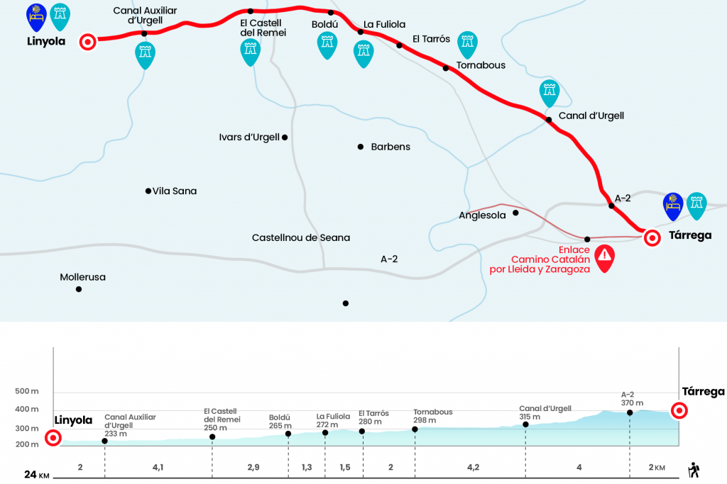
Enlarge map
Points of interest in the stage 4: Tàrrega to Linyola stage
The route
From Plaza del Carmen we cross Avenida de Catalunya to continue through Carrer de Sant Pelegrí, before crossing the train tracks we take to the left the Carrer del Segle XX, where we meet the train station. Next to the stairs is the plate of the Associació d’Ámics de ls Pelegrins to Santiago – Barcelona, whose yellow arrows we will follow until San Juan de la Peña. We follow the carrer Segle XX for 250 meters to cross the line Barcelona-Manresa-Lleida through the step to the level with barrier. At the front we have the Parque de Sant Eloi, the place of recreation of the targarines, promoted by the Association of Friends of the Tree already in the first bars of the 20th century, which covers an altozano crowned by a chapel of the 13th century.
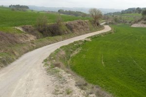
Precisely, diagonal to the left behind the tracks, we continue along the street dedicated to them the capital of the Urgell, the carrer dels Amics de l’Arbre. Following the perimeter of the Park connects with the camí de Tornabous, where a Generalitat banderola is 9 kilometers to that locality. We continue straight, without catching a local path that goes to the left and we cross the bridge over the A-2, a road that we say goodbye as it heads towards Lleida and Fraga (Km 2). At 350 meters, you have to turn 90 degrees to the left, following the trail of the Tornabous cami, which indicates the topographic maps. If we look up from the tozal, on the other side of the highway you see Vilagrassa and Anglesola, towns of the Southern Catalan Road that heads to Lleida, Zaragoza and Logroño. The gravel runway descends slightly from the muzzle, sprinkled by some grenades, along a raised canal as an aqueduct. Half a kilometer to the right is the finca Mas d’en Colom. It is frequent to see rabbits and make flying in this cerealist canvas that does not appear to have confines and where the first fruit lines of the Urgell are already seen. Three hundred meters from the canal we are still facing at a crossroads (Km 3,6). Advancing like a tyrannical, we spent a farmhouse and 250 meters later crossed the Canal de Urgell, a great hydraulic construction that allows to water with the water of the Segre about 70,000 hectares of cultivation (Km 6).
The intensive cultivation of fruit trees in the field is becoming apparent, especially from pears, apples and peaches. After the canal we go to the right, drawing a curve to another farmhouse with a welt: on the door dintel we read 1744. A good place to make the first stop, taking advantage of some of the shadows offered by the facade. Another line brings us closer to the farmhouse Antonio Ribalta, preceded by several moreras, and even a set of ships and unsheltered houses, where we turn left to tread a short asphalted section (Km 8.2). A few meters away, the banderola and the arrows encourage us to follow the right of the construction. Less than half a kilometer we go by a raft and a one kilometer straight leaves us to the entrance of Tornabous, population of the Urgell with about 900 inhabitants whose toponym, also reflected in the coat of arms of the municipality, refers to oxen circling under a yoke. Although on the site they point out that the name of the people can come from Arabic and mean ‘under the tomb’. El Camino passes through the town by the carrer La Libert. In the carrer Major, the parallel street to the right, we find a bar that can be reached quickly from the fountain (Km 10.2).
At the exit of Tornabous is the parochial church of Santa Maria, where we cross Lluís Companys Avenue to take along the sports club the paved section that leads to El Tarròs, a small town attached to Tornabous. There's a fountain at the entrance, on the right hand. It runs in front of the Raval del Molí and the carrer La Pau (Km 12,2). After the office we turn 90 degrees to the right (eye, do not wake up) and take a paved track that advances for a kilometer until C-53. We crossed the road with great caution to enter La Fuliola. We start the urban section by the Carrer de l'Om that leads to Fons, until reaching the Carrer Portal, where we pass under one of the doors of the old walled villa (Km 13,7). On the other side is a bar and a fountain, and a stone carving set in 1980 commemorating the 900 years since the founding of this population. On the right is the Baroque church of Saint Lucia, of 1783, but the Jacobean itinerary continues ahead by the carrer Cervantes, reaches the Guillem D’Isarm square and takes diagonal, on the right, the carrer Ponent.
A paved track now advances to the next population, Boldú, also from the municipality of La Fuliola. At the height of the term cross (Km 15) we turn left towards the church of Santa Maria, of Romanesque origin but very transformed. On the back of the temple, next to swings, we have another fountain. At the exit of Boldú we link with a gravel trail, always at the mercy of the elements, passing by the cemetery and surrounded by the immensity of agriculture. At 20 minutes we crossed the LV-3344 (the step has good visibility) and continued straight looking for the shade of the poplars and plataneros. At 400 meters from the road we pass the second acequia of the Canal de Urgell and a few hundred meters we enter the Castell del Remei. It is a wine production estate of the designation of origin Costers del Segre that belongs to the municipality of Penelles, in the region of La Noguera. The land was previously known as Bishop's Tower. We receive the castle (Km 17.9) and then the Shrine of the Mare de Déu del Remei, the work of Antón Fisas consecrated in June 1954. There is also an oil mill, a good restaurant and, in the end, there is a swamp where we can also replenish forces to face the last 6 kilometres of the day.
A runway runs between vines the Castell and 200 meters, as a piece of the Tetris, we turn 90º to the left and then 90º to the right to host a line of almost two kilometers between crops. It ends in a cross that we follow to the right and in short turn to the left as we pass the acequia of Boldú, which runs to us. We started another marshal line, this time with the urge to see the silhouette of Linyola to contraluz. The passage over the Emergency Canal (Km 21,7) gives continuity to the soliloquium. After the roundabout to Linyola, a population of 2,700 inhabitants integrated in the region of Pla d’Urgell, we headed towards the urban center. We enter by the carrer de Pau Clarís and turn right on a slight rise by the carrer de Calderón de la Barca. Through Plaza Ángel Guimera we continue to the church of Santa Maria, Gothic and Renaissance style and notable for its octagonal bell tower with four surveillance towers projected in the late sixteenth century by Bartomeu Roig (Km 24).
The difficulties
Remarks
In images
What to see, what to do

¿Do you want to send any photo of "The Camino de Santiago"?
If you have any photos of "El Camino de Santiago" that you want to share with us, you can send them to us and enlarge the photo gallery
Forum: What pilgrims think about the Camino de Santiago
See all