Article translated by an automatic translation system. Press here for further information.
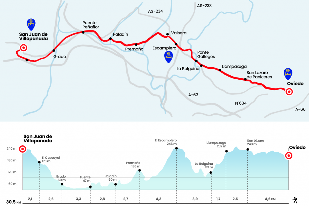
Stage from Oviedo to San Juan de Villapgale
Comfortable day for the first day, homogeneous journey.
Information about the stage 1: Stage from Oviedo to San Juan de Villapgale
Enlarge map
The route
Caution: The Grado hostel closes from late October to March.
- Km 0. Oviedo (All services)
Following the wake that Alfonso II el Casto and his entourage left, back in the ninth century, on their way to the newly discovered tomb of the Apostle James the Elder, we began the pilgrimage from the Cathedral of San Salvador. To the left, along Schultz Street, part the Primitive Road; to the other direction the Camino del Norte or the Costa is heading. Following the bronze shells that adorn the pavement (a vertical sign would certainly have helped more), we turn right on Schultz Street on
St. John's Street. We follow it and link it to Covadonga Street, which in turn connects with Melquiades Álvarez . It is linked to the street of Independence. As we leave to the avenue of the same name, coinciding with the N-634, we turn left and pass by the Asturias and Cervantes towers. With the presence of the already desired yellow arrows, we cross the pedestrian avenue Príncipe de Asturias, commonly known by the sheep as Plaza de La Losa. He leaves Samuel Sanchez Street, in honor of the cyclist Olympic champion in Beijing, and continues along the street of the Argañosa, which crosses this famous neighborhood of Oviedo. After a good break through this vial we turn right next to the bar El Clash to cross the tracks of the FEVE, where we also see the first Jacobean Cairn (Km 2.5). After the tracks, although depending on the state of the works, the itinerary leads to a
twist to the right by Calle Bermudo I El Deacono. It then continues left by José María Fernández Buelta and right by Illas Street, which leaves to Florida Avenue. In the roundabout we find 300 meters there is a size of Santiago peregrino sculpted in bronze by the Asturian artist Pilar Fernández Carballedo. After a playground we continue along Calle Paredes de Nalón and surrounded a plot to go to the local road that goes up to San Lázaro de Paniceres.
- Km 4.6. San Lázaro de Paniceres (Bar)
A six-pillar panera welcomes us in San Lázaro, where there was a malatry for the care of the lepers. We can stop to see Mount Naranco, on whose top is the sculpture of the Sacred Heart. The sierra also houses prerogative churches such as Santa María del Naranco and San Miguel de Lillo. By local road we left La Braña and Pachuca on the right hand and before reaching Las Campas we took the diversion to Villama. Among meadows, oak trees, chestnuts and some other laurel, by neighborhood road and waste concrete slopes that fit the undulating terrain, we reach Llampaxuga and its Carmen chapel. We can take a deserved breath and seal the credential.
- Km 7.1. Llampaxuga
We left the chapel and turned right into a steep descent. Bicigrine eye, the track is full of grooves! We crossed the Huerta trail, we arrived next to the traditional laundry of La Pipera, with table and a couple of banks, and we climbed up to Llubrio. Then we visited the parish of Lloriana>, with its church of Santa Maria. Already documented in the 12th century, today it does not look its best version. From here you can see the height of the Escamplero. We go down to AS-232 to enter La Bolguina.
- Km 8.8. La Bolguina (Bar)
A bar-restaurant at the foot of the road is the highlight. By the same AS-232 we access the village of Fabarín, where we left the road to cross the Gallegos bridge over the river Nora, tributary of the Nalón. We say goodbye to the municipality of Oviedo to access that of Las Regueras. We go back to the road to cross the population of Gallegos and, listen!, because between kilometric points 7 and 8 we leave the road on the right to enter the place known as El Castañéu del Soldáu. A pleasant riverside path, populated by large chestnut trees, leads to the mill of Quintos (Km 11). A steep slope starts here, passing next to the Arroxos site and flows into the AS-232 a few meters from the top. We left Casa Concha on the right hand and took the diversion to Valsera and Santullano by AS-234. We pass by the Bar-Restaurant El Tendejón de Fernando, where the keys of the hostel are collected, and next to the ultra-violet butcher. The hostel is located a few meters later, in a left hand diversion.
- Km 12.7. El Escamplero (Hostel. Pension. Bar. Store)
We followed AS-234, leaving Taraniello aside, and left the road on the left before reaching p.k 1. We descend back to AS-234 to enter Valsera, with its chapel of Fatima on the edge of the itinerary (Km 13.8). After the hermitage we left the road and entered a paved runway that surpasses a vaguada between meadows and limestone hills. As we approach La Rabaza, we enter a path that is born to the left hand. We go so far as Picarín, where we cross the Andallón River (Km 16). A trail leads to the road leading to the hospitable population of Premoño.
- Km 17. Premoño
At the entrance is the modest chapel of Santa Ana, the only visible trace of the old pilgrim hospital. Until December 2013, the Bar Feliciano was opened, which served many walkers for generations, but has been closed since then. We left the road on the right at the height of a panera and we went down to the valley of Araje by a beautiful path between chestnut and oak trees and fruit trees. A rough section avoids the actions of the Llonga stream. We will soon pass the diversion to the Roman baths of Santa Eulalia de Valduno, located only 300 meters from the itinerary. In the same detour, just 150 meters from the Camino, is the Bar-Tienda Casa Dylsia, which opened in November 2014.
- Km 18.1. Valduno (150 mt from the Camino) (Bar-Shop)
On a herbose road we reach La Fuente, where we meet Alonso Pevida House. We left the road and followed it to the right, enjoying the views of the Nalón, the longest Asturian river with 140 kilometers. So, on a perch, we arrived in Paladin, where on the right hand 30 meters is the Hostel Villa Palatina (Bar, restaurant and cafeteria from 7:30 to 22:00). Then we cross one of the tributaries of the Nalon: the Soto.
- Km 19.7. Paladín (Hostel. Restaurant. Bar)
We rode by road and traverse Puerma. In a few hundred meters we left the asphalt on the left and passed by the house known as El Fornu. A riverside path, crossing the Xanas gateway, leads us to the AS-234. Paying attention to this dangerous road section, we enter L'Arache or Laracha.
- Km 22. L'Arache (Bar)
Next to the road is the bar Aurina. We entered a few meters into the Council of Candamo and crossed the Peñaflor Bridge, ravaged by the virulence of the Nalón in 1586 and the scene of not few disputes during the War of Independence. As noted by Juan Uría in Las Peregrinaciones a Santiago de Compostela, here nearby, Alfonso VII ordered the building of a lodge in 1144. We went out to the no less dangerous N-634 to reach the church of San Juan, of Romanesque origin and lobby of Peñaflor belonging to the Grade council.
- Km 22.9. Peñaflor
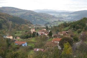
We leave the national and we access this parish of about 250 inhabitants. See!, because at 250 meters you have to turn right hand and pass under the tracks of the train. A track crosses the Grad Valley, an extension of cultivation well fed by the channels of the Cubia and the Nalón, although it has come less in recent decades. We enter Grado through the neighborhood of San Pelayo, where we cross the roads. After these we go left onto Railway Street and then turn right onto Bridge Street. We saved the Cubia River and continued down the main avenue. Next to the park of San Antonio we left the avenue on the left to progress to the City Hall Flies, Albiceleste building of 1848.
- Km 25.8. Bachelor (All services)
We turn right and continue through the squares of Dolores and General Ponte to take Cimadevilla Street, which brings us closer to N-634, coinciding with Flórez Estrada.Some
450 meters later we leave the N-634 on the left, where Acevedo points out. It is the neighborhood of La Cruz, where, according to Uría, "I raise a cross of term indicating the continuation of the road". A steep lane progresses between scattered neighborhoods and takes a break at La Quinta. On the left hand, in the remoteness, the Sierra del Aramo is distinguished. Later we crossed over a link of the highway, which has blurred the physiognomy of the parish of Villapvintage, and after La Barrera we reached the neighborhood of El Cascayal (Km 28,4). Six hundred meters after passing through the neighborhood of El
Valle we reached the diversion that heads to the hostel of San Juan de Villaphaya. Before reaching the old commandment of Villapgale or Leñapgale, which belonged to the Order of St. John of Jerusalem, we passed through the district of La Reguera. The hospital Domingo Ugarte took the witness of Don Leopoldo a few years ago and managed to impregnate in Villapgale a vigorous Jacobean spirit.
- Km 30.5. San Juan de Villaphaya (Hostel)
The difficulties
Remarks
In images
What to see, what to do
The hostels

¿Do you want to send any photo of "The Camino de Santiago"?
If you have any photos of "El Camino de Santiago" that you want to share with us, you can send them to us and enlarge the photo gallery
Forum: What pilgrims think about the Camino de Santiago
See all