Article translated by an automatic translation system. Press here for further information.
Irun to San Sebastián Stage
The Santiago International Bridge on the Bidasoa
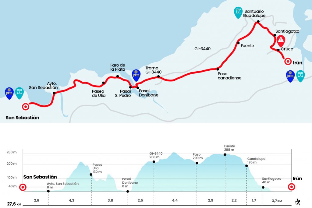
Information about the stage 1: Irun to San Sebastián Stage
Enlarge map
The route
- Km 0. Irún (All services)
We leave the hostel, to our right where there is a roundabout, we take the GI-2134 direction Hondarribia for a few meters later pass under the GI-636, we continue through the GI-2134 to within half a kilometer reach a large roundabout which we cross to continue in front and pass over a estuary, nothing more crossing the bridge we have to turn left, eye
- Km 3. Chapel of Santiagotxo
At the crossroads of the hermitage we continue on the left hand and as half a kilometer we take the way up to the Shrine of Guadalupe. It's 155 meters of slope and just over a kilometer. It should be dosed to the maximum because the stage is long and broken legs. In the last ramps you can already see the plush tower of this shrine that keeps the polychrome size of the patron of Hondarribia. It is believed that it comes from the mask of a Basque vessel. Next to the temple there is a fountain (pray not fit for consumption) and behind a bar-restaurant. Also behind, within walking distance of the shrine and outside the itinerary, there is a fort of the year 1900 (Km 4.7).
- Km 4.7. Shrine of Guadalupe (Bar-Restaurant)
The panoramic is amazing, with an unbeatable view of the bay of Txingudi. On the other side we see Hendaya and our Hondarribia and Irun. Next to the Shrine we take a trail next to the Jaizkibel Forest House, the name of the mountain that we will border from now on. In short, after a few stairs, the road is divided into a couple of options: one for 'alpinists', more spectacular that goes up and follows the GR-11 (links about 3 km with the official route) and that of the pilgrims of all life. We resumed the march for the latter. The runway is comfortable, spacious and surrounded by conifers and quite chestnut trees. We went by a camouflaged fountain with the inscription Year 1940 (Km 6,9) and soon the trail descends.
In this section we may see some pottokas, a poni originating from the Basque Country. If the descent has rained, it may be slippery and the 'bicigrines' will have to carefully manage the successive curves. Next we crossed a Canadian step and turned right towards Pasaia (Km 9.8). The profile is a bit of a broken leg for a couple of kilometers in which we'll draw another Canadian step. Then, the trail descends for as many miles through a beautiful mixed forest, surpasses the indication of Pasaia Donibane 3.4 km and reaches GI-3440 (Km 14.2).
We took it forward, ascending, and 150 meters after kilometric point 4 we left it on the left. At this point the stage presents us with a biased V-view of the lighthouse and the Pasaia cove. The subsequent sharp descent makes a dent, the backpack pushes forward more than it should and should be allowed to carry and not retain inertia with the quadriceps, which will end up painful. We enter Pasai Donibane through the Larrabide neighborhood and on the stairway we find the left diversion to the Santa Ana hostel, for those who wish to stay here. The rest continue to descend to the houses and the pier. Pasaia is divided into four districts: Pasai Donibane, Pasai San Pedro, Pasai Antxo and Trintxerpe.
- Km 16.7. Pasai Donibane/San Juan (Hostel. Bars. Shops. Outpatient clinic. Pharmacy. ATM)
Here we take a small motorboat for a modest price and save the few meters that separate us from Pasai San Pedro. After landing we head to the right, along Torreatze Street, and we walk along the river towards the sea and pass by a Maritime Cultural Center. We come across a row of stairs that will become endless if we start it with too much joy. It leaves the Faro de la Plata road and 150 meters before reaching the building we turn left on a coastal path towards San Sebastian.
- Km 18.9. Faro de la Plata
This beautiful route by the sea is quite wavy. We walk the ruins of an old water run and in a shadowy anchored we leave a small stone custard. The path ends in the neighborhood of Paseo de Ulía (Km 20,5).
We pass by number 375, where there is a community that welcomes the pilgrim and later we arrive at a parking lot. Here is the diversion to the youth hostel Ulía, which is 150 meters away. They don't give dinners and it's pretty far away from the city. The Camino descends through an enviable environment to a spectacular viewpoint over San Sebastian. First, the beach of Zurriola and Kursaal and after the mouth of the Urumea the beach of Concha and Mount Igeldo is seen. We still have a long and nice walk to the hostel. After the panoramic we turn right and descend abruptly to Zemoria Street of San Sebastian (Km 23,4).
Eye to signaling in the city, it's easy to take off. We continue further down to the right by Avenida de Navarra and we go to the walk parallel to the beach of Zurriola. There is little loss. We pass past Kursaal, cross the Urumea River and do the same with the Alameda del Boulevard (here is the Tourist Office). Soon we stood next to the City Hall. Remember that on the right hand is the old town of San Sebastian, where everyone should get a good round of pintxos.
- Km 24.8. San Sebastian (City Hall) (All services)
We continue in front of the famous and endless beach of the Concha. After the tunnel under the Miramar Palace we will see in the pedestrian pass of the left some yellow arrows (in sticker). They are oriented towards the hostel of pilgrims of the Ikastola Jakintza, managed by the Association of Friends of the Camino de Guipúzcoa and which opens during the months of July and August. The signs lead by an office of the People's Bank and continue in front of Matia Street until the crossing with Escorta Real Street.
For the rest of the months, if our intention is to sleep in the youth hostel La Sirena, we must go straight after the tunnel and pass through the walk a stretch of the beach of Ondarreta. Then turn left hand to continue in parallel on Satrústegui Avenue and past the Ezeiza hotel turns left to catch the Igeldo stroll. Number 25 is the youth hostel.
- Km 27.6. San Sebastian (Youth Hostel) (All services)
The difficulties
Remarks
In images
What to see, what to do
The hostels

¿Do you want to send any photo of "The Camino de Santiago"?
If you have any photos of "El Camino de Santiago" that you want to share with us, you can send them to us and enlarge the photo gallery
Forum: What pilgrims think about the Camino de Santiago
See all