Article translated by an automatic translation system. Press here for further information.
Stage from Hontanas to Boadilla del Camino
Intense day because there is no place to stay cold or hot
Information about the stage 14: Stage from Hontanas to Boadilla del Camino
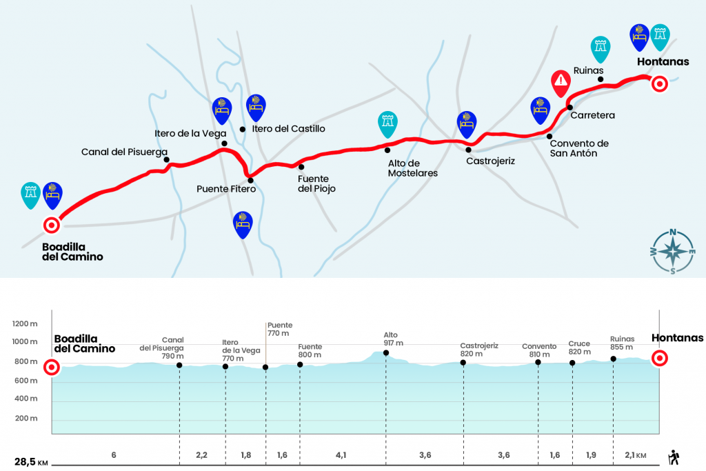
Enlarge map
Points of interest in the stage 14: Stage from Hontanas to Boadilla del Camino
The route
- Km 0. Hontanas (Hostels. Hostel. Casas Rurales. Bar. Store in season)
Real de Hontanas Street leads to the BU-P-4013 road, which we leave immediately to take a road that starts right. Passing by the ruins of a tower (Km 2.1), we end at the foot of the road (Km 4).
The road has no arches and instead a row of portentous strawberries whose shade makes transit much more bearable. Soon, at the bottom, we already distinguish the ruins of the convent of San Antón, whose arches rise above the road (hostel and bar in season). It was founded in 1146 by Alfonso VII and, in it, the Antonian monks treated the patients of an infectious gangrene known as 'San Antón fire'. The cause of this evil, now well known, was a fungus that altered the grain of rye (Km 5,6).
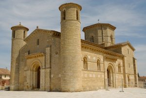
After crossing the arc of triumph that resembles the skeleton of the convent, we approach the line of more than two kilometers that plants us in Castrojeriz, the last Burgese villa on the Camino de Santiago. It spreads in the form of a half-moon to the skirts of a hill that dominates a primitive castle. The first thing that comes to pass is the former Gothic collegiate of
the Virgen del Manzano. Later he turns to take Real East Street and discover a hull of blasphemed houses and traditional architecture. Soon we passed, on the right hand, the church of Santo Domingo, gothic and with an elegant Plateresque cover of the 16th century. As a curiosity, on the side of the street there are a couple of skull killers.
The slope culminates in Plaza Mayor, equipped with supports to take a break.
- Km 9.2. Castrojeriz (All Services)
The artistic visit of Castrojeriz is revived by the church of San Esteban, converted into a cultural center and hostel for pilgrims, and the church of San Juan, designed by the architect Rodrigo Gil de Hontañón in German gothic style. On the same street, now called Real de Poniente, we left Castrojeriz to face it up
to the Teso de Mostelares, a geographical landmark and an indelible memory of the pilgrimage to Compostela. The accused repecho starts meters after crossing the River Odrilla by a wooden bridge. In one kilometer and three hundred meters we exceed an elevation of 140 meters, from 777 we climbed to 917 meters, which carries an 11% average slope. On the high we receive a humiliating geometric (Km 12,8).
Even with its breath, we cross the plain of
Mostelares to gradually discover the unencompassed landscape of Tierra de Campos, also known for the surplus barn of Spain. Region of palomares, rich in hunting and overflowing with art or as Aymeric Picaud reported - a land full of treasures, of gold, silver, rich in cloths and vigorous horses, abundant in bread, wine, meat, fish, milk and honey but lacking in trees. For four kilometers, the road, a white and dazzling line to the sun, leads us through a favorable terrain to the
merendero located next to the fountain of the lice (Km 16,9).
We then took for nine hundred meters the road that goes to Itero del Castillo, with hostel, and we left it on the left to arrive next to the old parish of San Nicolás - today hostel of seasonal pilgrims managed by volunteers of the Italian Confraternity of San Giacomo - and then act to the Fitero or de la Mula bridge over the river Pisuerga. This is where Burgos ends and Palencia begins. The original work was built during the reign of Alfonso VI the Bravo (1072 - 1109), but there is nothing left of this factory and we see today are added
and reconstructions of the bridge erected in the 16th century.
- Km 18.5. Puente Fitero (Hostel)
A rural road on the banks of the Pisuerga brings us closer to Itero de la Vega, the first palentine locality of the Camino (Km 20,3). The chapel of Nuestra Señora de la Piedad, of the 13th century, is the first monument to emerge at the pass. Already in the village are the church of San Pedro and a jurisdictional roll.
- Km 20.3. Itero de la Vega (Hostels. Hostel. Bar. Store)
We crossed Itero by Santa Ana Street and, after crossing a road, we continued a couple of kilometers per piste to the irrigation canal of Pisuerga (Km 22.5). Almost two kilometers later, after saving an undulation of the land, it is shown at the bottom Boadilla del Camino(Km 24,3).
A brutal esplanade of greens, gold and ochres still separate us from our destination, which we managed to reach after a final four-kilometre throw. Despite being a small town, Boadilla has several hostels where to stay. Along with the church of the Asuncion stands
an ornamented large Gothic jurisdictional roll. It's a must visit.
- Km 28.5. Boadilla del Camino (Hostels. Bar)
The difficulties
Remarks
In images
What to see, what to do
The hostels

¿Do you want to send any photo of "The Camino de Santiago"?
If you have any photos of "El Camino de Santiago" that you want to share with us, you can send them to us and enlarge the photo gallery
Forum: What pilgrims think about the Camino de Santiago
See all