Article translated by an automatic translation system. Press here for further information.
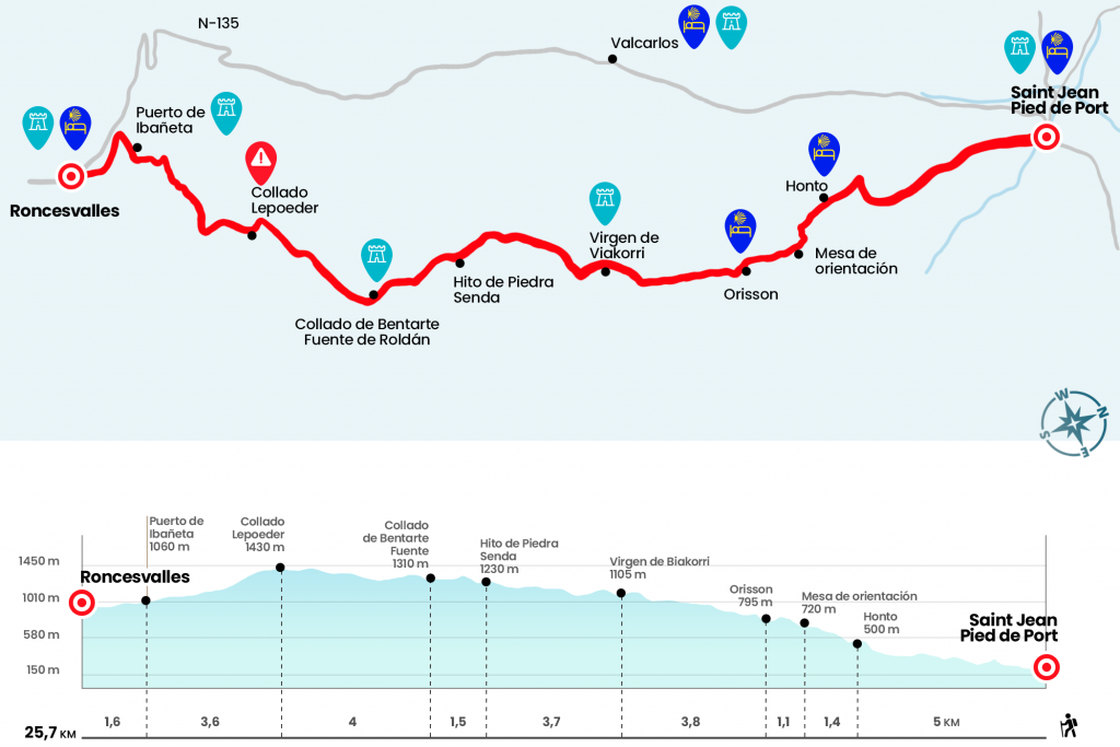
Saint Jean Pied de Port to Roncesvalles
Enjoy the border landscapes between Spain and France.
Information about the stage 1: Saint Jean Pied de Port to Roncesvalles
Enlarge map
Points of interest in the stage 1: Saint Jean Pied de Port to Roncesvalles
The route
- Km 0. Saint Jean Pied de Port (All Amenities)
The French Way – the Camino par excellence, the mother of all the roads to Santiago – we started it on the medieval bridge over the Nive River. This is how we access rue d’Espagne, a neighborhood of merchants and craftsmen that has hardly changed its physiognomy over the centuries. We cross the street from one end to the other to cross the walls of the old wall and reach a wooden pole. Nailed, next to a shell and the red and white mark of the GR 65, there is a sign indicating Chemin de Saint Jacques de Compostelle. After all, one poster points to the other route by Arnéguy and Valcarlos, which runs right (see difficulties).
Route 1.
A terrible repecho then welcomes us and should be tackled very slowly, thus facilitating progressive warming at a stage which will require a great deal of effort and which must be taken very calmly. Moreover, to avoid excessive suffering and even a probable scare it is recommended to be well-trained. On the way up the rural road we pass intermittent neighborhoods of houses, like Iruleya and Erreculus, always surrounded by green praderías. The sections where we regain our breath are diluted like a mirage and soon the dreadful ramps come again that will bring us to the core of Huntto.
- Km 5. Huntto (Hostel)
After Huntto, the road gives us a small truce and takes its place a path that wins the slope with a succession of horseshoe curves. Back on the asphalt we went with a fountain and a guidance table. It is located in an excellent viewpoint where you get a panoramic view of Saint Jean Pied de Port and the smooth orography of this area of French Aquitaine (Km 6.4). One kilometer later there is the hostel and bar-restaurant of Orisson, another alternative to spend the night, especially for the traveller who has started the stage in the afternoon.
- Km 7.5. Orisson (Hostel. Bar-Restaurant)
We continue on the mountain road, surely in the company of Manech sheep and rugged horses insensitive to the rigors of the climate. About four kilometers later, about a hundred meters and on the left hand, you can distinguish over a rocky ridge the size of the Virgin of Biakorri, adorned with flowers, necklaces, crosses, shells and other pilgrim offerings (Km 11,3). After twenty minutes of walking we passed the detour that went down to the French town of Arnéguy and two kilometers later, finally, we reached the key point of the day. Next to the right wing there is a stone milestone with a wood sign carved with the inscription Roncevaux/Orreaga (Km 15).
It means leaving D-428 and continuing to mount through. We immediately pass by the cross of Thibault, also full of objects and flaps, and we rise between two hills, leaving on the right a quiet stone refuge (Km 15,6). Under the slopes of the Leizar Atheka peak we travel the small kilometer remaining to the Bentarte hill, where the Roldán Fountain is located, reminiscent of the Charlemagne official defeated by the Vascones with his army in 778 (Km 16,5). A robust stone milestone announces our entry into Navarre and, shortly, a triple wooden sign encourages us to continue on the right. Under a tupid hayedo and a clearer stretch we reached the Izandorre shelter, located between the 43 and 44 beacons and vital in case of emergency (see Difficulties section). The stony track is hardened to reach the Lepoeder collado, the maximum height of the stage at 1430 meters (Km 20,5).
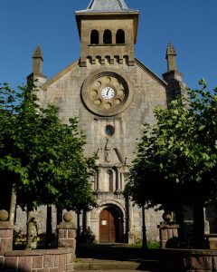
Here are two options to continue, well marked in a wooden pole. The one on the left is the shortest (3.6 kilometers to Roncesvalles), with the handicap descending by strong slopes. It's a beautiful stretch through the forest of Mount Donsimon. The option on the right is four hundred meters longer and passes through the high of Ibañeta, where the chapel of San Salvador is located. A matter of taste. We choose the longest and go down the paved runway, often tackling thanks to the red and white marks of the GR. The views are spectacular and lead us to discover the landscape of the stage of tomorrow: beech forests and Roncesvalles opening the doors to Burguete and the valley of Erro. Thus we arrived at Ibañeta, where is the pictured chapel of San Salvador, built in memory of an old cenobium that rung its bell to guide medieval pilgrims (Km 24,1).
At the stage there is only one sigh and, after passing by the Bird Migration Center, our itinerary goes through the forest to go down to Roncesvalles, represented by the Gothic Collegiate of Santa Maria. The first building that comes to pass is the pilgrimage hostel.
- Km 25.7. Roncesvalles (Hostel. Bar-restaurant. Tourist Office)
Route 2.
(mandatory from 1 November to 31 March. Note: see difficulties)
- Km 0. Saint Jean Pied de Port.
We recall that this variant is mandatory from 1 November to 31 March.
To take this variant once we cross the Porte d'Espagne we continue facing a hundred meters, once there we turn right through the Chemin de Mayorga, which will take us to the national road D 933 which we take about 750 meters, we turn right to cross the river Nive d'Arnéguy Riviere and continue on the right of the river sales and the road to Spain. Here we have bars, shops and restaurants. In front of the Sale Peio we take a track that will take us to Arnéguy in a kilometer and a half.
- Km 8.2.Arnéguy.
Once in Arnéguy we crossed the Luzaide River and at the same time the border entering again in France to continue along the paved runway this time leaving the river and the road to our right, we continued for about three kilometers until we reached Valcarlos where we entered again crossing the river and reentering Spain.
- Km 11.5. Valcarlos.
We leave Valcarlos, a town with all the services including pilgrim hostel on the National Highway 135 to divert us after about two and a half kilometers to the left by a local road to the Gainekoleta neighborhood, once we take a way there that leads us back to the National 135 which we take again, after continuing about two kilometers of national road we take back to the left to descend next to the river,
- Km 22. Puerto de Ibañeta.
once in the port (1057 meters high) we descend by road to reach Roncesvalles in just under two kilometers, a town to which we enter the height of the pilgrim refuge.
- Km 23.7. Roncesvalles.
The difficulties
Remarks
In images
What to see, what to do
The hostels

¿Do you want to send any photo of "The Camino de Santiago"?
If you have any photos of "El Camino de Santiago" that you want to share with us, you can send them to us and enlarge the photo gallery
Forum: What pilgrims think about the Camino de Santiago
See all