Article translated by an automatic translation system. Press here for further information.
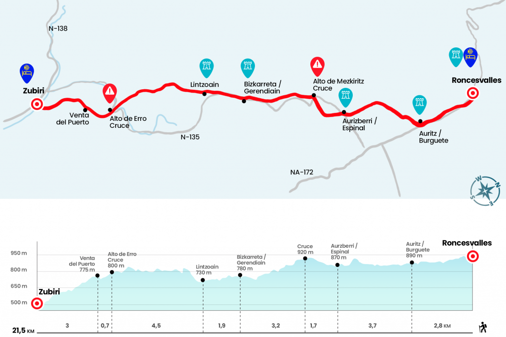
Roncesvalles to Zubiri stage
Information about the stage 2: Roncesvalles to Zubiri stage
Enlarge map
Points of interest in the stage 2: Roncesvalles to Zubiri stage
The route
- Km 0. Roncesvalles (Hostel. Bar-Restaurant. Tourist Office)
From the Itzandegia hostel we go to the N-135 to take a path that is born next to the right arches and runs through the forest of Sorginaritzaga or Bruges robledal. After a hundred meters you can see on the other side of the road the cross of the Pilgrims, a Gothic cruise that was moved to this place in 1880 by the Prior don Francisco Polite. The bucolic walk ends when we arrive next to the ships of the Ipetea polygon, where we turn left to go to the N-135 and enter Auritz/Burguete.
- Km 2.8. Auritz/Burguete (Hostels. Casas Rurales. Bars. Store. Health Center. Pharmacy. ATM)
St. Nicholas Street and the road are all one, so through it we cross the town, as there is no arcén between the sturdy blasphemed houses and the asphalt. In the population there are a couple of bars that open early, the first by church and another hundred meters later. After passing the parish of St. Nicholas we turn right next to a bank branch to cross a walkway on a stream that goes down to the Urfing River. We continue on a runway, flanked by some ships and extensive stocked cattle meadows and deciduous sheet sketches. After bypassing several streams of water by rudimentary stone vados and solving a repecho, we left a paved runway from which we already appreciate the frosty roofs of Espinal, the first town in the Erro valley. We entered the urban area to go to the N-135 to the height of the modern church of San Bartolomé
- Km 6.5. Aurizberri/Espinal (Hostels. Hostel. Casas Rurales. Bar. Store. Office)
We turn right (here we have a bar and then a bakery) and we continue down the sidewalk. Right after a walk of pedestrians we turn left and on tracks of different floors we climb up to the top of Mezkiritz. Next to the arcén is a carved image of the Virgen de Roncesvalles (Km 8.2). When we cross the road, look! Because we can wake up and take the path it is not. There is one that leads to the Altos de Errebelu but we must follow the Jacobean path. A metal cancelling encourages us to enter the impressive hayedo, where the understory of boj, acebos and ferns guides us to the next population. A final section, paved to keep the mud away, leaves us by the road, where an artificial path leads to Bizkarreta, end of stage in the 12th century thanks to the existence of a pilgrim hospital.
- Km 11.4. Bizkarreta/Gerendiain (Rural Cottage. Bar. Store. Office)
At the entrance, on the left hand side, we found a bar. We leave the town by the Tiendica de Biskarret and head to Lintzoain, almost two kilometres away.
- Km 13.3. Lintzoain (Bar. Posada)
Once in Lintzoain we passed by the fronton and turned right to take a very steep cement cartilage. It is followed by a gravel trail - a cairn takes care of reminding us of the four remaining kilometers to the top of Erro - and continues through a narrow path. The first ramps are the hardest, but the slope cedes and the path widens. There are even good sections on a clear descent, like the one that leads us to the very top of Erro, where we cross the N-135.
- Km 17.8. Alto de Erro (Bar-van in season)
Between April and the end of October there is a mobile bar that works with solar panels. It has soft drinks, fruit, energy bars and pastries and in spring it also serves hot drinks
.
We take a trail and at seven hundred meters we set aside the place where the Sale of the Port was located, the old inn from which there are no more than remains today. Then the descent becomes more evident, leads us to open and close a pair of portilles and we are surprised by some step section. In the end, we are at the Rabies Bridge over the Arga River, a construction through which we access Zubiri and the Steribar Valley.
- Km 21,5. Zubiri (All services)
The difficulties
Remarks
In images
What to see, what to do
The hostels

¿Do you want to send any photo of "The Camino de Santiago"?
If you have any photos of "El Camino de Santiago" that you want to share with us, you can send them to us and enlarge the photo gallery

Forum: What pilgrims think about the Camino de Santiago
See all