Article translated by an automatic translation system. Press here for further information.
Phase from Comillas to Unquera
There are three estuaries that offer a beautiful landscape to the pilgrim
Information about the stage 16: Phase from Comillas to Unquera
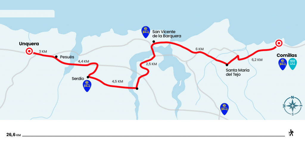
Enlarge map
Points of interest in the stage 16: Phase from Comillas to Unquera
The route
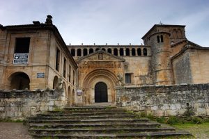
We leave the old prison of Comillas, converted today into a magnificent hostel for pilgrims, and we go down to the Paseo de Solatorrre towards San Vicente de la Barquera. The beginning runs parallel to the CA-131 by a bike path where you can admire on your left hand the surroundings surrounding the Palacio de Superllano. Without leaving the rail the route crosses Rubárcena and crosses the narrow Rabies Bridge over the estuary of the same name. Formed by the mouth of the rivers Turbio and Captain lies within the Oyambre Natural Park, an oasis for landscape lovers and ornithology. After the driveway you have to turn left hand in strong ascent on a paved runway. It is going to go off the road where, again on the left hand, we reach the church of Santa María del Tejo, built on the remains of an old monastery and that still retains its canecillos and arquivoltas from the Romanesque period.
Going to the CA-363 we enter the rural core of El Tejo and descending towards the Santa Marina golf course. Designed by Severiano Ballesteros, always in memory, it has a social club located in a 16th-century house. There is no choice but to cross part of the resort, surrounded by green, and to save the bridge over the Captain’s creek. Then you go by the 17th century chapel and you leave the sports facility on a paved runway. We climbed through it to the church of San Pedro, ahead of La Revilla, population of the municipality of San Vicente de la Barquera. Hostel Llambres is located at the foot of CA-131, right at p.k. 29 (one kilometer right). At the foot of the N-634, at p.k 27, is the VA hostel. Aventure.
On a road we will soon see the Maza Bridge, entrance door to Saint Vincent de la Barquera. This stone driveway began to be built in the late sixteenth century on the previous wooden. In the Civil War, it was pretty thin and rebuilt and widened as we see it today. We advance through him over the Ría de San Vicente, formed by the mouth of the Escudo and Gandarilla rivers. After crossing the estuary, it is possible to avoid entry into St. Vincent, but it would be unfortunate to leave the village which has made it even more famous, if possible, Mr. Bustamante. Also, at the top of the population, the hostel of pilgrims of Saint Vincent rises.
After visiting this fishing village, also overlooking the agrestes Picos de Europa, we continued the asphalt march to La Acebosa, which we arrived after passing over the A-8 and crossing the train tracks. Note, right after crossing the bridge of the A-8 there is a marked shortcut that leads us directly to Serdio without going through "the Acebosa" or "Hortigal", you can save 2 kilometers of road through tracks and stone roads. From the Acebosa, a population close to the 150 inhabitants awaits an ascending section with great views that gives a great rodeo and descends to the CA-843 towards Pesués. First we will reach Hortigal, on the banks of the Gandarilla River and later to Estrada, village of the municipality of Val de San Vicente where its tower stands out. It is a medieval fortification made in masonry and has around it a walled enclosure and the remains of a moat. It was original from the 8th and 9th centuries but was rebuilt in the 13th century.
After the defensive mole we left the asphalt on the right and retook it in 15 minutes to enter Serdio, place of Val de San Vicente with hostel of pilgrims. We left Serdio, and on the left hand we went to another paved runway to get into another. On the left hand is Muñorrodero but the Camino continues to the right to pass under the train path and cross the bridge over the Tina Menor estuary, mouth of the Nansa River.
We save the estuary to climb up a left runway that leaves us up to the N-634 in Pesués. We go up a road and then enter a wooded path that is born on the left hand and descends sharply into the last section. The trail transports us to the entrance of Unquera . It is a town of services, but without hostel, so if we are looking for a Jacobean environment we will have to cross the bridge over the river Deva that makes border between Cantabria and Asturias and thus reach the nearby town of Bustio, with private hostel, or continue a couple of kilometers to Colombres, also with private hostel, located at the entrance.
The difficulties
Remarks
In images
What to see, what to do
The hostels

¿Do you want to send any photo of "The Camino de Santiago"?
If you have any photos of "El Camino de Santiago" that you want to share with us, you can send them to us and enlarge the photo gallery
Forum: What pilgrims think about the Camino de Santiago
See all