Article translated by an automatic translation system. Press here for further information.
Stage from Zafra to Almendralejo
The stage can be extended to Almendralejo, capital of the Earth of Barros
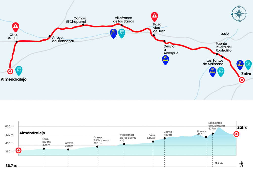
Information about the stage 7: Stage from Zafra to Almendralejo

Enlarge map
Points of interest in the stage 7: Stage from Zafra to Almendralejo
The route
- Km 0. Zafra(All services)
The pilgrimage continues from Calle Ancha de Zafra, next to the tourist hostel Vía de la Plata. We follow her in front and link to San Francisco Street until we cross the road. At the front, the San Francisco Tower, the only rest of a former 15th-century convent. We went with her and an urbanization to take the path that ascends, among particular properties, to the Sierra de San Cristobal. We descend by a pinar to the very entrance of Los Santos de Maimona, first and only village to Villafranca de los Barros, located over fifteen kilometers. We enter the population on Zafra Street and continue to the Plaza de España. Here, in front of the City Hall, is the Church Nuestra Señora de los Angeles, which we surround on the left to pass next to its silver front.Remember that in February 2015 the new pilgrim hostel was premiered located on the street Maestrazgo.
- Km 3.9. Los Santos de Maimona (All services)
We must not lose sight of the trail of the yellow arrows, which lead to crossing the road EX-364 and to continue along the road network of this Pacense town. We leave Los Santos de Maimona crossing the bridge over the Rivera de Robledillo (Km 5). On our right, more than a kilometer away, the railroad tracks and our inseparable N-630. Ahead of it, a long stretch of olive vines and antiquisimos awaiting patients the yes or no of an oil refinery, whose uncertain construction is giving much to talk. We will go next to the diversion heading to an old almazara, where we can find the Hostel la Almazara reopened.(km 12.2)
Later we reached the junction with the road of Ribera del Fresno or the Moros. We turn for him, to the right, looking for the railroad tracks and the N-630. We're going through the arcén a few meters, passing under the highway bridge, and we're leaving the road on a well-marked path that's born right. Leaving behind the national we turn left and progress for 4 kilometers to the gates of Villafranca de los Barros. We enter this town, named City of Music, by an autonomic road and, guided by the tiles decorated with the yellow vieira, we walk through the streets of the Chivalry, Zurbarán, Martínez and Larga to reach the plaza where the church of Nuestra Señora del Valle is located.
- Km 19. Villafranca de los Barros(All services)
We walk up Santa Joaquina Street, Plaza Corazón de Jesús and Calle Calvario to reach the chapel of the Coronada. On the left hand we take the street of San Ignacio, where the Institute Meléndez Valdés is located. We take the road and, seven hundred meters later, cross the road BA-6004. We continue, surrounded by olive groves that give way to the monopoly of the vineyard and the clay, the main ingredients of the landscape of the Barros region.
The public field El Chaparral will be our next reference, leaving the broad track on a narrower path between the vines (Km 23,7). In three and a half kilometers we reach a wider road through which we turn left towards the Bonhabal stream (Km 28,6). After this we head forward for almost an hour until the crossing with the road BA-013 (Km 32.9). The official route to Torremejía continues from the front. If we take the road to the left we will reach Almendralejo, almost 4 kilometers away.
- Km 36,7. Almonds(All services)
The difficulties
Remarks
In images
What to see, what to do
The hostels

¿Do you want to send any photo of "The Camino de Santiago"?
If you have any photos of "El Camino de Santiago" that you want to share with us, you can send them to us and enlarge the photo gallery


Forum: What pilgrims think about the Camino de Santiago
See all