Article translated by an automatic translation system. Press here for further information.
Phase from Galisteo to Cáparra
After passing the bridge over the Jerte there are ten kilometers of asphalt
Information about the stage 14: Phase from Galisteo to Cáparra
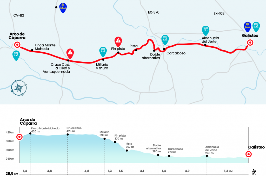
Enlarge map
Points of interest in the stage 14: Phase from Galisteo to Cáparra
The route
The composition we offer of the stages are merely informative, understanding that each pilgrim makes his way and decides his stages. In the case of today it would be most advisable to do the Carcaboso - Aldeanueva del Camino stage.
- Km 0. Galisteo(All Services)
We leave Galisteo by the door of the Villa, in the wall and we descend to the right in search of the medieval bridge that rises above the Jerte River on the outskirts of Galisteo, from here will start, very to our regret, more than 10 kilometers of road through the region of the Alagón Valley . To the right of the way flows the river Jerte, affluent of the Alagón that gives name to Aldehuela del Jerte , the first town we find and pass through five kilometers.
- Km 5.3. Aldehuela del Jerte (Bar in the Pensioner's Home)
Another 5 kilometers of asphalt separates us from our next reference, Carcaboso, which we access crossing the road EX-370, which if we follow it to the right would take us 12 kilometers to Plasencia .
- Km 10.2. Carcaboso(All Services)
We enter La Iglesia Street, where the parish of Santiago Apostle is located and where a small outdoor exhibition with the CI and CII miliaries has been enabled. At the end of the street we turn left to the Plaza de España and leave it on the right, along Calle Pozo. Back to a dirt road, finally, we continue to a point where we will have to choose where to proceed (Km 11,6).
We can go forward by following the yellow arrows on the acequia wall, faster alternative, or heeding the H1 granite cube that shows a yellow mark and diverts us right. The arrows do not respect the historical path, but the H1 that will lead us through it. Both options are valid. We choose the most faithful. We drifted right, and after giving a little rodeo, we recovered the direction north by turning left next to a dryer. Over the next two and a half kilometers we will advance along a track, surrounded by cattle and opening and closing cancellations as we go. We will arrive at a service road, which we follow on the left hand to open, a few meters later, a cancel by the acequia. Here are the two variants, the one that we bring and the one that followed those who chose to follow forward by the acequia (Km 15,7)
You have to climb the runway about a kilometer and a half and after passing a cancelation, at the height of a granite informative totem, you have to pay attention to leave the runway on the right to the path already gone. If we have not yet stopped to take a breath what better occasion. There will be few dehesas (Km 17.2). Following the already steep terrain, next to the endless wall, we arrived next to a lying miliary and another stone wall that cuts our way (Km 18,5). There is no choice but to open the cancellations that we have on our right and to continue parallel them on the other side. With the wall on our left, the route flows between holm oaks, cork oaks and some scattered lagoon. In five kilometers we reach the road of Oliva de Plasencia and Venta Quemada..
- Km 23.3. Carretera de Oliva de Plasencia (Albergue y Casa Rural over six kilometers – see observations)
We cross the road and go ahead. Let us now walk the Cañada Real de la Plata , also known as the Vizana, which coincides with the route of the Roman way. During the last six kilometers of stage, in the rainiest months, only a couple of streams will stand in our tour . The so-called Torrucas and White Charcos, which we will save thanks to the granite blocks conditioned on the course. After passing by the entrance of the finca Monte Moheda (Km 28,1) and a group of houses, the symbol of the Vía is already a few hundred meters away. It is none other than the Roman arc of Cáparra. Solitary, as fallen from the sky and leaned on a hesa of the Ambroz valley , has an attraction difficult to explain.
- Km 29.5. Parra (Interpretation Centre)
The difficulties
Remarks
In images
What to see, what to do
The hostels

¿Do you want to send any photo of "The Camino de Santiago"?
If you have any photos of "El Camino de Santiago" that you want to share with us, you can send them to us and enlarge the photo gallery
Forum: What pilgrims think about the Camino de Santiago
See all