Article translated by an automatic translation system. Press here for further information.
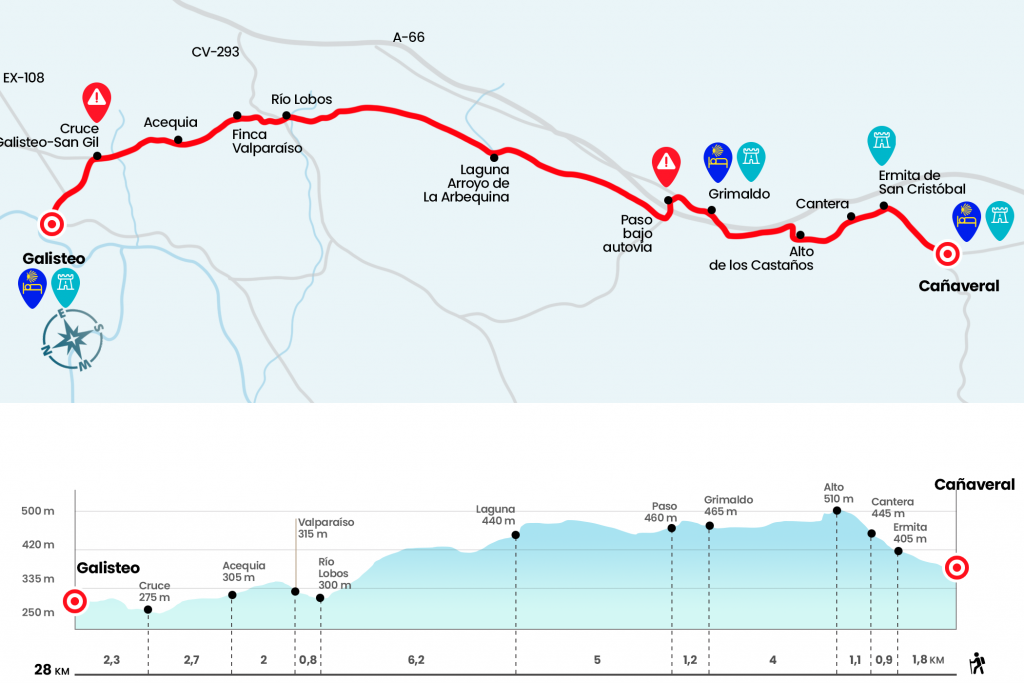
Phase from Cañaveral to Galisteo
A beautiful painting saves the level of the port of the Castaños
Information about the stage 13: Phase from Cañaveral to Galisteo
Enlarge map
Points of interest in the stage 13: Phase from Cañaveral to Galisteo
The route
- Km 0. Cañaveral(Hostels. Bars. Store. Cashier. Pharmacy. Office)
We leave Cañaveral down Calle Real and take the N-630, then turn left onto a dirt track that coincides with the natural road of the Tagus (Km 1,2). We go ahead, leaving the national on a path and we will arrive in about fifteen minutes by a house and a quarry (Km 2,7). Here begins the most tiring part of the climb to Puerto de los Castaños. The hardness quickly reverses on a lighter slope that reaches high through a pine tree (Km 3.8).
We cross the road (EX-371) we spend a cancelation and continue through a forest of holm oaks and cork trees through various streams. Before reaching the second cancel we can take the path that emerges on the right hand and leads to Grimaldo. If we do not plan to stop, we can go ahead.
- Km 7.8. Grimaldo(Hostel. Casa Rural. Bar)
Those who have stopped at Grimaldo follow a short section of the N-630 and take the left hand detour that leads to Holguera by the CC-S-4. Beware!After passing under the motorway A-66 (Km 9) you have to take the first detour to the right. A cube with a green-yellow tile indicates that we are on the right trace. On the other side of the road will come those who did not enter Grimaldo.
We are always going forward, passing several cancellations between scattered trees. Later we will find two cancellations, one on the left and one on the front. Passing the one on the left would go to Riolobos, 4 kilometers away. Going forward towards Galisteo.
Thus, from the front, we will spend several more cancellations taking into account the signaling, he needs in this whole section. The itinerary leads next to the Arroyo Boquerón reservoir. The pilgrims cross the stream by a comfortable step under the dam. After passing it we left to the CC-29.3 road, following it to the right in the direction Plasencia. About 350 meters away, we left her by the left wing. A granite cube encourages you to continue down a dirt road. No more loss!
Then there will no longer be any cancellations, they are all Canadian steps. After the diversion we continued for 2.2 kilometers to the irrigation canal. We cross it and enter a new fenced path that brings the indication:‘Camino de Santiago, prohibited motor vehicles’. We walked through it for 900 meters until we crossed the nuns stream. From the regate we continue to the first granite indicator of the Vía, where we turn left. (At this point there is a marked detour with an informative panel on the original Roman road that goes straight to Carcaboso but does not pass through Galisteo, saves little more than a kilometer) Two hundred meters later we turn right, continuing without loss to Galisteo.
- Km 28. Galisteo(All Services)
The difficulties
Remarks
In images
What to see, what to do
The hostels

¿Do you want to send any photo of "The Camino de Santiago"?
If you have any photos of "El Camino de Santiago" that you want to share with us, you can send them to us and enlarge the photo gallery

Forum: What pilgrims think about the Camino de Santiago
See all