Article translated by an automatic translation system. Press here for further information.
Moreruela to Benavente Farm Stage
Any road parallel to the N-630 is used to prevent asphalt
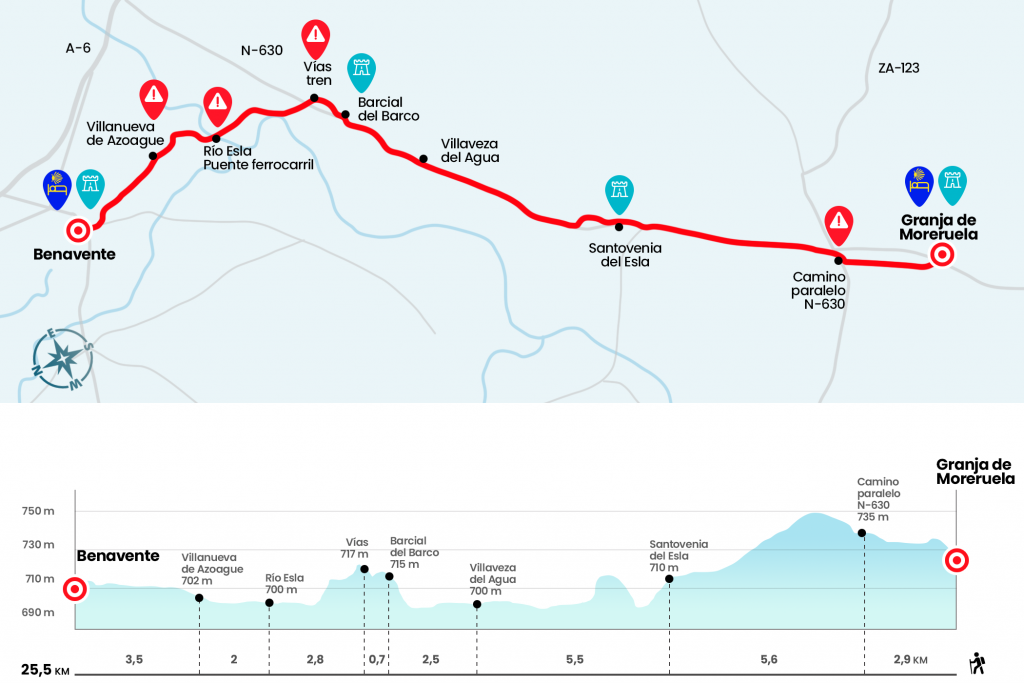
Information about the stage 23: Moreruela to Benavente Farm Stage
Enlarge map
Points of interest in the stage 23: Moreruela to Benavente Farm Stage
The route
- Km 0. Moreruela Farm(Hostel. Bar. Store)
Behind the church of Granja de Moreruela is marked in a pole the bifurcation of the Paths. On the left, towards Orense on the Sanabrés Road; on the right, towards Astorga continuing along the Silver Way. We face this last option and for this we go up the streets San Juan and the Bodegas to take a track that we follow a few hundred meters to an antenna. Notice because at this point, mismarked, by the way, we should not go forward, but we have to turn right, go back a few meters along the side and twist left to catch the track for which we will definitely move forward.
As a reference we will walk parallel to the N-630, which is about three hundred meters on the right hand. The runway is a long line of almost two kilometers that goes to the road heading to Tábara (km 2.5).When we reach it we turn right to take a road to the left in a few meters along a forest that goes parallel to the N-630. At 2.5 kilometers we will stop to a track that we take to the left to later turn to the right and cross the A-66 for an elevated step, we continued the direction that we took until we crossed a road and entered into Santoacepía del Esla.
- Km 8.5. Santozzo del Esla(Bar. Shops)
The village passes through the N-630 and after passing the church of Nuestra Señora del Tovar we will find on the right a singular source of three cots and abrevadero. Behind it is necessary to take a road that arrives, after passing over the Prado Ramiro stream and a short echo, to the graveyard situated on the edge of the N-630. The next 600 meters continue along a small path next to the right shoulder of the road. Just until a yellow arrow forces us to cross it and follow another hundred meters down one path across the national one. After this dance we continue to Villaveza del Agua through the arcén and a small path next to an acequia that avoids asphalt.
- Km 14. Villaveza del Agua (Bar. Store)
We crossed this population of Villaveza by the same national and 150 meters before the end of population poster we took a track that was born to the left. It leads us directly to the nearby Barcial of the Boat, where the octagonal tower of the church of Santa Marina stands out.
- Km 16.5. Barcial Boat(Hostel. Bar)
- Leaving Barcial we take a street to the right of the national that leads us to the green road, old railway line that we take to the left to cross the N-630, we continue on the green way until we cross an old railway iron bridge the Esla River, (eye because here you can follow through the green road to Benavente without passing through Villanueva de Azoague or continue on the "official" path
- Km 22. Villanueva de Azoague(Bar)
The signs always guide us in front and lead us to take the road ZA-P-2545, taking as a reference the spectacular tower of the Azucarera Ebro. We passed by her and in seven hundred meters we reached the entrance of Benavente. Instead of reaching the inlet roundabout, we left a few meters before the road on a road that leads to saving the N-525 under a bridge. So we got to Carretera de la Estación Street where the yellow arrows shine by their absence. To reach the hostel you have to continue everything straight, pass the Castle and follow to the old railway station and the Parque La Pradera, a place used by the City of Benavente to locate the refuge.
- Km 25.5. Benavente(All services)
The difficulties
Remarks
In images
What to see, what to do
The hostels

¿Do you want to send any photo of "The Camino de Santiago"?
If you have any photos of "El Camino de Santiago" that you want to share with us, you can send them to us and enlarge the photo gallery
Forum: What pilgrims think about the Camino de Santiago
See all