Article translated by an automatic translation system. Press here for further information.
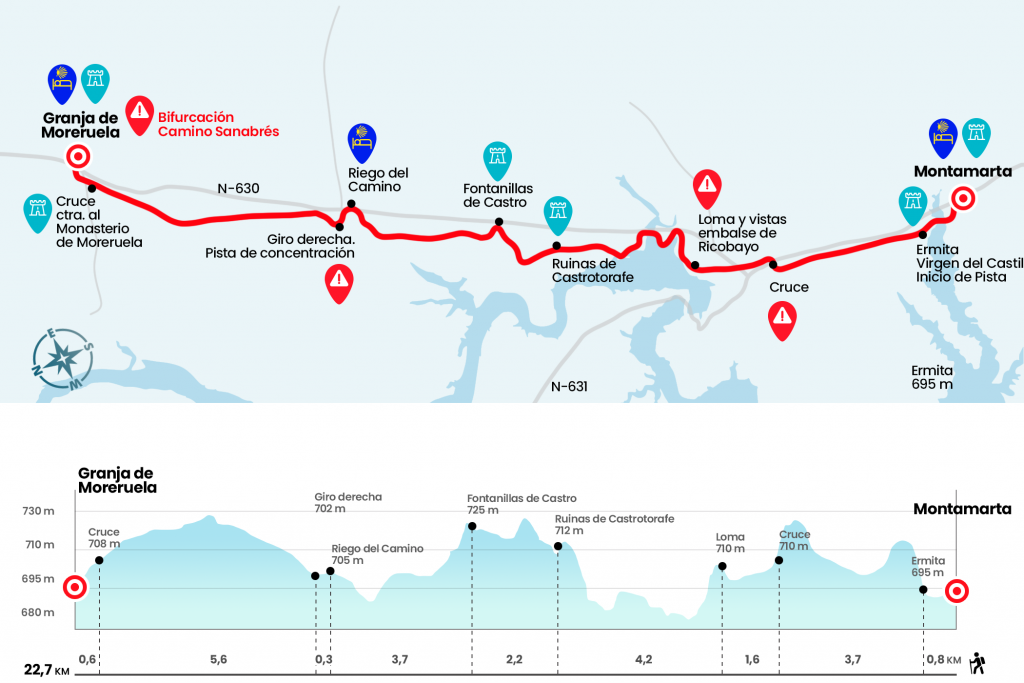
Montamarta to Moreruela Farm
At Granja de Moreruela the road forks to reach Santiago
Information about the stage 22: Montamarta to Moreruela Farm
Enlarge map
Points of interest in the stage 22: Montamarta to Moreruela Farm
The route
- Km 0. Montamarta(Hostel. Bar. Store. Pharmacy)
We opened the day with the church of San Miguel Arcángel. At his feet is a sculpture dedicated to the Zangarrón, an ancient character provided with a mask and a trident whose role is to represent the fifths the days of New Year and Kings. We leave Montamarta and take a road that shortly goes down to the tail of the Ricobayo reservoir. The chapel of the Virgin of the Castle rises above a farallon, safe from the waters. Left hand left by stopping to a runway (Km 0.8).
After the hermitage which we left to the left we continue on a track running parallel to the national one that we have on our right, after about three kilometers we reach the line of the AVE which we cross below and follow the track to later cross the N-631 and end up on the N-630 which we will leave on the right and cross the highway A-66, we will continue to cross the bridge no further.
We cross a bridge first the N-630 and then the A-66 highway, turn right to little by little by piste go away from them, (km 9).
After a kilometer and a half we reached the junction of the ruins of Castrotorafe, an important city of the 11th century that guarded the bridge over the Esla River and was finally abandoned in the 18th century. Some historians have placed here a mansio of the Roman road known as Vico Aquario (Km 10.5). The road does not enter the enclosure, but this medieval city deserves at least a short visit. We left the detour behind and continued the road to turn right in just over a kilometer towards Fontanillas de Castro, which has enabled a refuge with several literas.
- Km 12.5. Fontanillas de Castro (Refugio. Bar. Shop at the petrol station)
We leave Fontanillas on Calle Barca and take the right track, which in three kilometers leaves us without setbacks at the gates of Irrigation del Camino, population with pilgrim hostel (temporarily closed).
- Km 16.2. Irrigation of the Road(Temporarily closed hostel. Bar. Store)
From the national we take in oblique a street, well signalized, to slowly turn right onto a track that later continues parallel to the A-66 which we cross and continue parallel to it now leaving it to our left. Four and a half kilometers later we will cross the road heading to the monastery of Moreruela and enter Granja de Moreruela. After a right-hand turn on José Rodríguez Joaquín Street we arrived at the national one.
Once in Granja de Moreruela will decide whether to continue along the Vía de la Plata in the direction of Astorga or the Camino Sanabrés, which crosses the region of Sanabria, arrives in Ourense and continues through Galician lands to Santiago de Compostela.
- Km 22.7. Moreruela Farm(Hostel. Bar. Store)
The difficulties
Remarks
In images
What to see, what to do
The hostels

¿Do you want to send any photo of "The Camino de Santiago"?
If you have any photos of "El Camino de Santiago" that you want to share with us, you can send them to us and enlarge the photo gallery
Forum: What pilgrims think about the Camino de Santiago
See all