Article translated by an automatic translation system. Press here for further information.
Step from Puebla De Sanabria to Lubián
Advances by Cobra and the Castro river to Terroso
Information about the stage 5: Step from Puebla De Sanabria to Lubián

Enlarge map
Points of interest in the stage 5: Step from Puebla De Sanabria to Lubián
The route
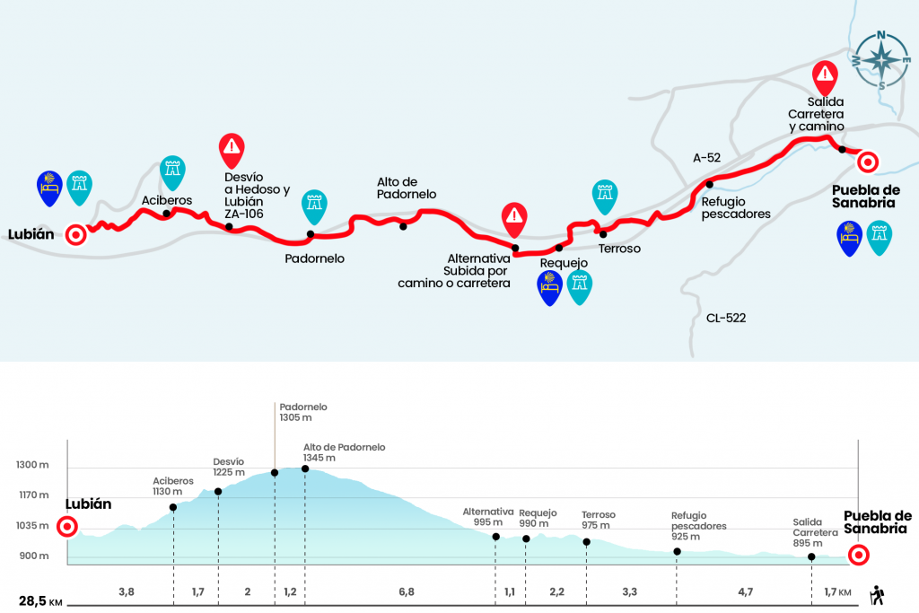
- Km 0. Puebla de Sanabria (All services)
Whether from the historic center of Puebla de Sanabria or from the lower part of the town, located on the other side of the Tera River, we take the road that links with the N-525 and passes over the Castro River. From here, leaving the stone bridge to the right, we continue along this paved path of scarce arcén for a kilometer, since before reaching the directions to Orense or Zamora we have to take a path that is born to the left (km 1,7). Right here is a wooden sign that says "Camino de Santiago. Welcome to the City of Collectors." The road goes down to the river Castro, advancing along with him. They alternate sections of comfortable floor with other more annoying chants. The signalling tablets serve as a guide in this simple stretch that leads alongside a concrete and aggregate company called Los Peperrines (Km 4).
After the factory we went out to the N-525 and walked through it, leaving behind the kilometric points 88 and 89. Between this and the kilometric 90 point, at the height of the crossing to Santa Colomba, we left the road to the left to cross a stream. We went through an area of extraction of aggregates and, shortly, next to a refuge of fishermen, good place to guard against bad weather and to cater for a good lunch (Km 6.4). We advance about 600 meters by the river and turn ninety degrees to the right along a path drawn field through. Unfortunately, the poor and poor signalling at this point can cause us to stop and search for the safe company on the national road, situated only a few hundred metres to our right.
Perhaps it is our best choice, as we only walk 500 meters and just past kilometric point 91 we leave the asphalt on the right following the direction marked by another grid. It enters us on a path that runs to the left of the highway and reaches the place of Quirigual, where the church of Santiago is located and a cruise that arose in August 2012, replacing the oldest in the 1950s (Km 9). We left this construction behind and turned left to cross the road, take a shortcut across the football field and enter Terroso.
- Km 9.7. Terroso
One of his neighbors, Andrés Silvan, carries a pilgrimage record and has several stamps for credential. We crossed this town along Headero street and, at the exit, crossed over the A-52 to resume the journey through a path in a slight ascent. Taking care of the arrows, which lead us to take a couple of shortcuts, we reach a high where a poster wants us a "Good Way". As the forest descends, there may be no indications, so we have to take as a reference the path of the left. After overcoming it, we passed over the highway and entered Requejo. After crossing the N-525 we went by the chapel of the Virgin of Guadalupe to enter the village.
- Km 11.9. Requejo (Hostels. Bars. Store)
At the exit of Requejo we took a paved runway that leads to the cemetery. To this day you can no longer climb the Padornelo by road due to the works. The road has become the only alternative. A pity, as in 2012 the employment workshop La Alaba de Puebla de Sanabria cleaned and adjusted the final section of this trail (a total of 2.4 kilometers). With resignation turn right to return to the N-525 (Km 13).
The rise for the National is more monotonous, but smoother. The climb takes about 7 kilometres and ranges from kilometric point 95 to 101, after which a tunnel of 435 metres in length is crossed and the port of Padornelo is crowned (Km 19,8). After the tunnel, on the descent and already in the lands of Alta Sanabria, we left the road to take a cement trolley that reaches Padornelo, also passing near the church of Santa María de la Asunción.
- Km 21. Padornelo (Hostal. Bar-Shop)
After we regained our breath we went back to the national, leaving behind a gas station and a hostel. After a kilometer and a half we reached the deviation that marks Hedroso and Lubián by the ZA-106 (Km 23). Here begins the provisional route that will be maintained for several years! Instead of taking the detour, we go down the service track for half a kilometer, and another yellow arrow on a grid points to a descending path coming to the left. After a dozen meters down, we went through a tunnel and a few meters later there is another one. As soon as we pass it, we take a path to the left. All these turns are signposted with wooden tablets. However, this is an area where animals are released from the Camino and could pull or move some of the signs.
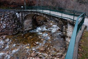
After this second tunnel begins a nice road between retama and old oak which has been blown away in its most abrupt part by operators of the Lubian City Hall. It goes down to a small creek, where they have also set up blocks of smooth stones to save the flow. We go to the bottom of the town of Lubián, to which we end accessing by the road where the pilgrim hostel is located.
- Km 28.5. Lubián (Hostel. Bar. Store. Pharmacy)
The difficulties
Remarks
In images
What to see, what to do
The hostels

¿Do you want to send any photo of "The Camino de Santiago"?
If you have any photos of "El Camino de Santiago" that you want to share with us, you can send them to us and enlarge the photo gallery


Forum: What pilgrims think about the Camino de Santiago
See all