Article translated by an automatic translation system. Press here for further information.
Stage of Rionegro Del Puente to Puebla De Sanabria
Carballeda is abandoned to conquer the lands of Baja Sanabria
Information about the stage 4: Stage of Rionegro Del Puente to Puebla De Sanabria

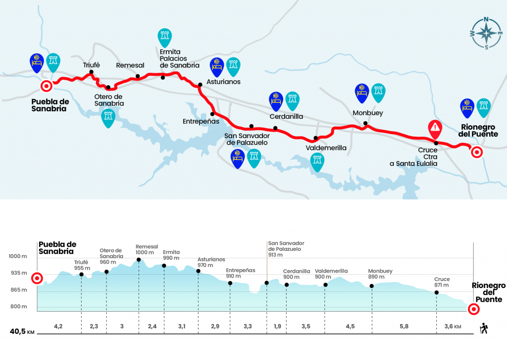
Enlarge map
Points of interest in the stage 4: Stage of Rionegro Del Puente to Puebla De Sanabria
The route
- Km 0. Rionegro del Puente(Hostel. Bars)
We walk out the street of La Vereda, which is hitting the side of the hostel, and turn right next to the ruins of the old school. Here we take a road, a hundred meters away from the N-525, by which we say goodbye to the last houses of Rionegro del Puente. Later we crossed a bridge over the A-52, the so-called highway of the Rías Bajas. As soon as we go, we turn left and walk parallel to the highway for just over a kilometer. We are distancing ourselves from the highway to cross the road heading to Santa Eulalia (Km 3,6).
With the reference of the N-525, which advances to our left, we follow a well-marked open field path with wooden strips. The Mediterranean forest of previous days has been replaced by more Atlantic species such as oak and aliaga, commonly known as tojo, a thorny bush of yellow flowers omnipresent in Galician lands. As the kilometers pass, the path ends up approaching the N-525 and, after a gas station and a hostel, we access Mombuey.
- Km 9.4. Mombuey(All services)
We head to the church of Santa Maria, notable for its Romanesque tower of clear defensive appearance, and we pass by the cruise. On the paved runway we cross a diversion from the national to take a path between oak which is glued to the arcén (Km 10). Two kilometers later we crossed a bridge over the highway and then the roads of the AVE, point from which they begin to see granite studs with engraved scallops, a wager and investment from the Municipality of Cernadilla that deserves our applause. After its wake we arrived to Valdemerilla, a small pedanía from the municipality of Cernadilla that maintains a church dedicated to San Lorenzo.
- Km 13.9. Valdemerilla
We enter the population through Prince of Asturias Street and then leave it by the Plaza de la Constitución. The section of more than 3 kilometers that separates Valdemerilla from Cernadilla does not present any difficulty, so after going through it we enter this last village next to the chapel of the Christ, turn left and pass shortly to the height of the Baroque church of the Purification, which we left at hand left.
- Km 17.4. Cernadilla (hostel, temporarily closed)
By cement track and some asphalt we will advance to San Salvador de Palazuelo, another hamlet from the Municipality of Cernadilla. Here is another hermitage and a little later the church of the Transfiguration. If we're animated, we can climb up the exterior staircase to its bell-tower. The views are great.
- Km 19.3. San Salvador de Palazuelo
At the exit of Palazuelo we take a large forest track that goes down and up to a road. After crossing it we take a road that after 600 meters reverses in asphalt and leads to the entrance of Entrepeñas.
- Km 22.6. Entrepeñas(Rustic House)
From here to the next population they mediate approximately forty minutes on a road that will lead us to cross the AVE tracks and soon after the highway. In Asturians we go to the N-525 at the height of the parish of Nuestra Señora del Carmen.
- Km 25.5. Asturians(Hostel. Bars. Pharmacy)
If we don't want to follow the arrows inside the population, because they take us back to the national one, we can move 400 meters down the shoulder of the road and take the signalized detour that comes out on the right hand and continues on another secondary road. A few hundred meters later we left it on the left to take a road, later piste, which leads us to pass through the upper part of Palacios de Sanabria (Km 28,6 of the stage).
- Km 28.6. Palaces of Sanabria (Bar)
After passing the hermitage we cross a road and go to a path surrounded by robles melojos. Given the large number of corks, this section is ideal for watching them. The path leads us, after crossing two roads, to Remesal.
- Km 31. Remesal
We are now heading towards the next locality, Otero de Sanabria, 3 kilometres away again crossing the highway.
- Km 34. Otero de Sanabria
The journey through Otero, which leads us to follow the tradition of passing by the church, this time the portentous St. Thomas Apostle, takes almost a kilometer and leads us to take a road to Orly not before crossing the highway again, this time by a tunel.
- Km 36,3. Yle
We went out in asphalt and, of course, we crossed the highway again to get out to the N-525. After 600 meters of arcén we reach the roundabout of entrance to Puebla de Sanabria, end of this marathon. Arrabal Street is 40.5 km away.
- Km 40.5. Puebla de Sanabria(All services)
The difficulties
Remarks
In images
What to see, what to do
The hostels

¿Do you want to send any photo of "The Camino de Santiago"?
If you have any photos of "El Camino de Santiago" that you want to share with us, you can send them to us and enlarge the photo gallery


Forum: What pilgrims think about the Camino de Santiago
See all